- Tenarunga
-
Tenarunga NASA-Bild von Tenarunga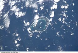
Gewässer Pazifischer Ozean Archipel Tuamotu-Archipel Geographische Lage 21° 21′ S, 136° 32′ W-21.35-136.53333333333Koordinaten: 21° 21′ S, 136° 32′ W 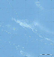

Anzahl der Inseln --- Landfläche 2,3 km² Lagunenfläche 5 km² Einwohner (unbewohnt) Karte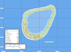
Tenarunga (alter Name: Minto Island) ist ein unbewohntes Atoll des Tuamotu-Archipels in Französisch-Polynesien. Es gehört geographisch zu den Actéon-Inseln und administrativ zur Gemeinde Gambier. Das Atoll liegt 15 km nordwestlich von Matureivavao und 6 km östlich von Vahanga. Die 5 km große Lagune der Insel hat keinen Zugang zum Meer.
Tenarunga wurde am 5. Februar 1605 vom portugiesischen Seefahrer Pedro Fernández de Quirós entdeckt.
Quellen
- Sailing Directions, Pub 126, "Pacific Islands" NIMA 2002; page-12
Weblinks
- Bild und Kurzbeschreibung (engl.)
- Volgewelt des Atolls (engl.)
- Fauna und Flora des Atolls (PDF, engl.)

Ahe | Ahunui | Akiaki | Amanu | Anaa | Anuanuraro | Anuanurunga | Apataki | Aratika | Arutua | Faaite | Fakahina | Fakarava | Fangatau | Fangataufa | Gambier | Hao | Haraiki | Héréhérétué | Hikueru | Hiti | Katiu | Kauehi | Kaukura | Makatea | Makemo | Mangareva | Manihi | Manuhangi | Maria Est | Marokau | Marutea Nord | Marutea Sud | Mataiva | Matureivavao | Morane | Motutunga | Mururoa | Napuka | Nengonengo | Niau | Nihiru | Nukutavake | Nukutepipi | Paraoa | Pinaki | Puka-Puka | Puka Rua | Rangiroa | Raraka | Raroia | Ravahere | Reao | Reitoru | Rekareka | Taenga | Tahanea | Taiaro | Takapoto | Takaroa | Takume | Tatakoto | Tauere | Tekokota | Tematangi | Temoe | Tenararo | Tenarunga | Tepoto Nord | Tepoto Sud | Tikehau | Tikei | Toau | Tuanake | Tureia | Vahanga | Vahitahi | Vairaatea | Vanavana
Wikimedia Foundation.
Schlagen Sie auch in anderen Wörterbüchern nach:
Tenarunga — Photo satellite de la NASA Géographie Pays … Wikipédia en Français
Tenarunga — Coordinates: 21°19′S 136°32′W / 21.317°S 136.533°W / 21.317; 136.533 … Wikipedia
Narunga — Tenarunga Tenarunga Photo satellite de la NASA Géographie Pays … Wikipédia en Français
Tenania — Tenarunga Tenarunga Photo satellite de la NASA Géographie Pays … Wikipédia en Français
Groupe Acteon — Groupe Actéon Photo satellite du Groupe Actéon: Matureivavao, Tenarunga, Vahanga et Tenararo (le nord est en bas du cliché) Le groupe Actéon ou encore îles du groupe Actéon sont 4 atolls faisant partie de l archipel des Tuamotu dans l Océan … Wikipédia en Français
Groupe Actéon — Carte des atolls composant le groupe Actéon. Géographie Pays … Wikipédia en Français
Îles du Groupe Actéon — Groupe Actéon Photo satellite du Groupe Actéon: Matureivavao, Tenarunga, Vahanga et Tenararo (le nord est en bas du cliché) Le groupe Actéon ou encore îles du groupe Actéon sont 4 atolls faisant partie de l archipel des Tuamotu dans l Océan … Wikipédia en Français
Tuamotus — Native name: Tuamotu Flag of the Tuamotu Islands … Wikipedia
Actéon-Gruppe — Lage der Actéon Inseln (1) im Tuamotu Archipel Karte der Inselgruppe. Die Actéon Inseln (frz. Îles du groupe Actéon oder vereinfacht Groupe Actéon) sind eine … Deutsch Wikipedia
Amanu-Atoll — Amanu NASA Bild von Amanu Gewässer Pazifischer Ozean Archipel Anzahl der Inseln … Deutsch Wikipedia
Tenarunga


18+
© Academic, 2000-2026
- Kontaktieren Sie uns: Unterstützung, Werbung
Wörterbücher Export, schritte mit PHP, Joomla, Drupal, WordPress, MODx.