- Vahitahi
-
Vahitahi NASA-Bild von Vahitahi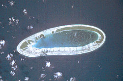
Gewässer Pazifischer Ozean Archipel Tuamotu-Archipel Geographische Lage 18° 46′ S, 138° 49′ W-18.773333333333-138.81777777778Koordinaten: 18° 46′ S, 138° 49′ W 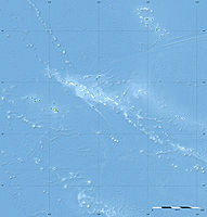

Anzahl der Inseln --- Landfläche 2,5 km² Lagunenfläche 7,4 km² Einwohner 83 (2007) Karte von Vahitahi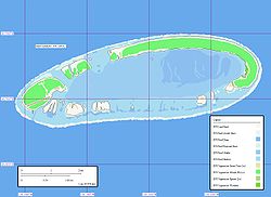
Vahitahi, auch Vaitake genannt, ist ein Atoll im Tuamotu-Archipel im Pazifischen Ozean. Politisch gehört es zu Französisch-Polynesien und dort zur Gemeinde Nukutavake. Vahitahi liegt dabei etwa 50 Kilometer nördlich der Hauptinsel Nukutavake.
Das ovale Atoll besteht aus einer größeren, sichelförmigen Insel im Nordosten, einer kleineren Insel im Westen sowie zahlreichen kleineren Motus. Die flache, zentrale Lagune ist vollständig von einem Korallenriff umschlossen. Die Landfläche beträgt etwa 2,5 km², die Fläche der Lagune 7,4 km². Nur die kleinere Insel im Westen ist bewohnt, die 83 Einwohner (Stand: 2007)[1] leben vorwiegend im Hauptort Mohitu. Dort befindet sich auch der Flugplatz von Vahitahi.
Vahitahi wurde 1768 vom französischen Seefahrer Louis Antoine de Bougainville für Europa entdeckt und von ihm ursprünglich Les Quatre Facardins genannt. James Cook erreichte das Atoll ein Jahr später und nannte es Lagoon Island.
Siehe auch
Einzelnachweise
- ↑ Institut Statistique de Polynésie Française (ISPF) - Recensement de la population 2007 (PDF, franz.)

Ahe | Ahunui | Akiaki | Amanu | Anaa | Anuanuraro | Anuanurunga | Apataki | Aratika | Arutua | Faaite | Fakahina | Fakarava | Fangatau | Fangataufa | Gambier | Hao | Haraiki | Héréhérétué | Hikueru | Hiti | Katiu | Kauehi | Kaukura | Makatea | Makemo | Mangareva | Manihi | Manuhangi | Maria Est | Marokau | Marutea Nord | Marutea Sud | Mataiva | Matureivavao | Morane | Motutunga | Mururoa | Napuka | Nengonengo | Niau | Nihiru | Nukutavake | Nukutepipi | Paraoa | Pinaki | Puka-Puka | Puka Rua | Rangiroa | Raraka | Raroia | Ravahere | Reao | Reitoru | Rekareka | Taenga | Tahanea | Taiaro | Takapoto | Takaroa | Takume | Tatakoto | Tauere | Tekokota | Tematangi | Temoe | Tenararo | Tenarunga | Tepoto Nord | Tepoto Sud | Tikehau | Tikei | Toau | Tuanake | Tureia | Vahanga | Vahitahi | Vairaatea | Vanavana
Wikimedia Foundation.
Schlagen Sie auch in anderen Wörterbüchern nach:
Vahitahi — Vahitahi, or Vaitake , is an atoll in the eastern area of the Tuamotu Archipelago, French Polynesia. Vahitahi s nearest neighbor is Akiaki, which is located 41 km to the northwest.Vahitahi is a small atoll with an elongated oval shape. It… … Wikipedia
Vahitahi — Photo satellite de la NASA Géographie Pays … Wikipédia en Français
Vahitahi — (antes Les Quatre Facardins y Lagoon) es un atolón de las Tuamotu, en la Polinesia Francesa. Administrativamente es una comuna asociada a la comuna de Nukutavake. Está situado a 50 km al norte de Nukutavake. Sus coordenadas son … Wikipedia Español
Vaitake — Vahitahi Vahitahi Photo satellite de la NASA Géographie Pays … Wikipédia en Français
Akiaki — Vorlage:Infobox Insel/Wartung/Höhe fehlt Akiaki Karte von Akiaki Gewässer Pazifischer Ozean … Deutsch Wikipedia
Akiaki — is a low coral atoll in the eastern area of the Tuamotu Archipelago, French Polynesia. Akiaki s nearest neighbor is Vahitahi, which is located 41 km to the southeast.Akiaki is a small atoll rising barely above sea level. The total land surface is … Wikipedia
Liste der Tuamotu-Inseln — Der Tuamotu Archipel (Französisch Polynesien) besteht aus 73 Atollen (einschl. Gambierinseln), fünf Inseln ohne Lagune (sämtlich gehobene Atolle, sowie zwei oder drei untermeerische Riffe, bei denen es sich um untergegangene Atolle handeln könnte … Deutsch Wikipedia
Tuamotus — Native name: Tuamotu Flag of the Tuamotu Islands … Wikipedia
Nukutavake — … Wikipedia
Amanu-Atoll — Amanu NASA Bild von Amanu Gewässer Pazifischer Ozean Archipel Anzahl der Inseln … Deutsch Wikipedia
Vahitahi


18+
© Academic, 2000-2026
- Kontaktieren Sie uns: Unterstützung, Werbung
Wörterbücher Export, schritte mit PHP, Joomla, Drupal, WordPress, MODx.