- Tuanake
-
Tuanake NASA-Bild von Tuanake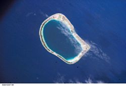
Gewässer Pazifischer Ozean Archipel Tuamotu-Archipel Geographische Lage 16° 40′ S, 144° 13′ W-16.666666666667-144.21666666667Koordinaten: 16° 40′ S, 144° 13′ W 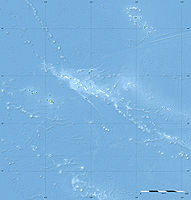

Anzahl der Inseln --- Hauptinsel --- Landfläche 6 km² Lagunenfläche 26 km² Einwohner (unbewohnt) Lage von Tuanake (8)
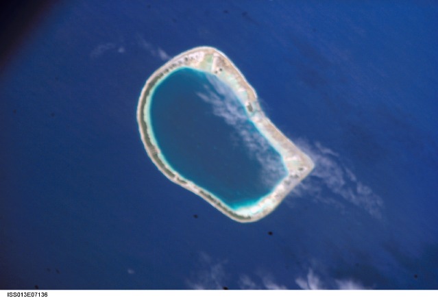
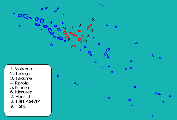
Tuanake (alter Name: Reid Island) ist ein Atoll des Tuamotu-Archipels in Französisch-Polynesien. Es liegt 24 km südwestlich von Makemo. Das Atoll hat eine halbrunde Form von ca. 9,5 km Länge und 5,5 km Breite. Die Lagune hat einen schiffbaren Zugang zum Meer im Südwesten. Das Atoll bildet zusammen mit Tepoto Sud und Hiti die Gruppe der Raevski-Atolle. Tuanake gehört zur Gemeinde Makemo welche aus den Atollen Makemo, Haraiki, Marutea Nord, Katiu, Tuanake, Hiti, Tepoto Sud, Raroia, Takume, Taenga und Nihiru besteht.
Tuanake wurde 1820 von dem Deutschbalten Fabian Gottlieb von Bellingshausen entdeckt.
Auf dem Atoll ist die Polynesische Erdtaube und der Tuamotu-Rohrsänger beheimatet.
Weblinks
- Bild und Kurze Beschreibung (engl.)
- Exakte Koordinaten (engl.)
- Tuamotu-Rohrsänger (engl.)
- Polynesische-Erdtaube (PDF, engl.) (142 kB)

Ahe | Ahunui | Akiaki | Amanu | Anaa | Anuanuraro | Anuanurunga | Apataki | Aratika | Arutua | Faaite | Fakahina | Fakarava | Fangatau | Fangataufa | Gambier | Hao | Haraiki | Héréhérétué | Hikueru | Hiti | Katiu | Kauehi | Kaukura | Makatea | Makemo | Mangareva | Manihi | Manuhangi | Maria Est | Marokau | Marutea Nord | Marutea Sud | Mataiva | Matureivavao | Morane | Motutunga | Mururoa | Napuka | Nengonengo | Niau | Nihiru | Nukutavake | Nukutepipi | Paraoa | Pinaki | Puka-Puka | Puka Rua | Rangiroa | Raraka | Raroia | Ravahere | Reao | Reitoru | Rekareka | Taenga | Tahanea | Taiaro | Takapoto | Takaroa | Takume | Tatakoto | Tauere | Tekokota | Tematangi | Temoe | Tenararo | Tenarunga | Tepoto Nord | Tepoto Sud | Tikehau | Tikei | Toau | Tuanake | Tureia | Vahanga | Vahitahi | Vairaatea | Vanavana
Wikimedia Foundation.
Schlagen Sie auch in anderen Wörterbüchern nach:
Tuanake — or Mata rua puna is a small atoll of the Tuamotu Archipelago in French Polynesia. It is located 24 km southwest of Makemo Atoll s westernmost point.Tuanake Atoll is roughly semicircular in shape. It measures 9.5 km in length with a maximum width… … Wikipedia
Tuanake — Photo de la NASA Géographie Pays … Wikipédia en Français
Mata-rua-puna — Tuanake Tuanake Photo de la NASA Géographie Pays … Wikipédia en Français
Mata-ruapuna — Tuanake Tuanake Photo de la NASA Géographie Pays … Wikipédia en Français
Pukamaru — Takume NASA Bild von Takume Gewässer Pazifischer Ozean Archipel … Deutsch Wikipedia
Taungataki — Katiu NASA Bild von Katiu Gewässer Pazifischer Ozean Archipel … Deutsch Wikipedia
Tepoto Süd — Tepoto Sud NASA Bild von Tepoto Gewässer Pazifischer Ozean Archipel … Deutsch Wikipedia
Islas Raevski — Las islas Raevski, Raeffsky, o Raéffski, son un grupo de tres atolones pequeños en el centro de las Tuamotu, en la Polinesia Francesa. Los tres atolones son: Hiti, Tepoto y Tuanake. Administrativamente depende de Katiu, comuna asociada a la… … Wikipedia Español
Tuamotus — Native name: Tuamotu Flag of the Tuamotu Islands … Wikipedia
Tepoto (South) — Tepoto Atoll (Tepoto Sud), or Ti Poto, is a small atoll of the Tuamotu Archipelago in French Polynesia. It is located 44 km southwest of Makemo Atoll.Tepoto Atoll is almost round in shape. It measures 3.8 km in diameter. Its lovely turquoise blue … Wikipedia
Tuanake

18+
© Academic, 2000-2024
- Kontaktieren Sie uns: Unterstützung, Werbung
Wörterbücher Export, schritte mit PHP, Joomla, Drupal, WordPress, MODx.