- Tahanea
-
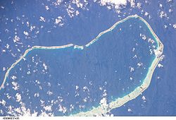
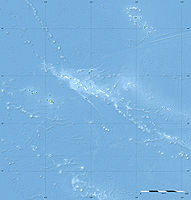
Tahanea NASA-Bild von Tahanea Gewässer Pazifischer Ozean Archipel Tuamotu-Archipel Geographische Lage 16° 52′ S, 144° 46′ W-16.866666666667-144.76666666667Koordinaten: 16° 52′ S, 144° 46′ W Anzahl der Inseln --- Hauptinsel --- Landfläche 7,7 km² Lagunenfläche 523 km² Einwohner (unbewohnt) Tahanea ist ein großes unbewohntes Atoll des Tuamotu-Archipels in Französisch-Polynesien. Das nächste Atoll Faaite liegt 12 km östlich entfernt. Tahanea erreicht eine Ausdehnung von 48 km Länge bei einer maximalen Breite von 15,2 km. Das Atoll ist von Riffen umgeben, welche im Süden etwas breiter sind als die im Norden, nahe dem Atoll gelegenen. Es existieren drei gut schiffbare Passagen zur Lagune, die Motupuapua, Teavatapua und Otao genannt werden.
Tahanea gehört administrativ zur Gemeinde Anaa.
Geschichte
Das Eiland wurde 1774 von Domingo de Boenechea entdeckt. Er nannte das Atoll San Julián
Ebenso wurde es von dem baltendeutschen Seefahrer Fabian Gottlieb von Bellingshausen 1820 im Rahmen einer Forschungsreise angefahren. Er gab dem Atoll den Namen Chichagov.
Heute sind es lediglich die Bewohner der Nachbarinseln, welche das Atoll manchmal aufsuchen um Kopra herzustellen.
Auf dem Eiland ist der Südseeläufer (Prosobonia cancellata) heimisch.
Weblinks
- Bild und Kurzbeschreibung (engl.)
- Liste Spanischer Seefahrer (engl.)
- Beschreibung des Sandläufers (engl.)
- Kurzer Reisebericht (engl.)
Ahe | Ahunui | Akiaki | Amanu | Anaa | Anuanuraro | Anuanurunga | Apataki | Aratika | Arutua | Faaite | Fakahina | Fakarava | Fangatau | Fangataufa | Gambier | Hao | Haraiki | Héréhérétué | Hikueru | Hiti | Katiu | Kauehi | Kaukura | Makatea | Makemo | Mangareva | Manihi | Manuhangi | Maria Est | Marokau | Marutea Nord | Marutea Sud | Mataiva | Matureivavao | Morane | Motutunga | Mururoa | Napuka | Nengonengo | Niau | Nihiru | Nukutavake | Nukutepipi | Paraoa | Pinaki | Puka-Puka | Puka Rua | Rangiroa | Raraka | Raroia | Ravahere | Reao | Reitoru | Rekareka | Taenga | Tahanea | Taiaro | Takapoto | Takaroa | Takume | Tatakoto | Tauere | Tekokota | Tematangi | Temoe | Tenararo | Tenarunga | Tepoto Nord | Tepoto Sud | Tikehau | Tikei | Toau | Tuanake | Tureia | Vahanga | Vahitahi | Vairaatea | Vanavana
Wikimedia Foundation.


