- Tekokota
-
Tekokota NASA-Bild von Tekokota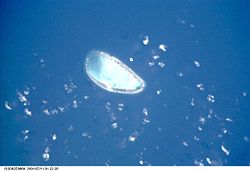
Gewässer Pazifischer Ozean Archipel Tuamotu-Archipel Geographische Lage 17° 20′ S, 142° 37′ W-17.333333333333-142.61666666667Koordinaten: 17° 20′ S, 142° 37′ W 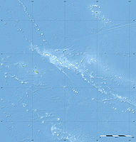

Anzahl der Inseln --- Hauptinsel --- Landfläche 1 km² Lagunenfläche 5,1 km² Einwohner (unbewohnt) Tekokota ist ein unbewohntes Atoll des Tuamotu-Archipels in Französisch-Polynesien. Das Hikueru Atoll liegt Tekokota 22 km in südlicher Richtung entfernt am nächsten. Das Atoll hat eine ovale Form von etwa 5 km Länge und 3,5 km Breite. Der westliche Teil des Atolls liegt unter Wasser.
Tekokota gehört administrativ zur Gemeinde Hikueru.
Geschichte
Tekokota wurde 1773 von James Cook entdeckt. Er nannte das Atoll Doubtful („Das Ungewisse“). Einige Monate später wurde das Atoll von spanischen Seefahrern gesichtet, die es mit neuen Namen bedachten. Den Namen "La del Peligro" (Das gefährliche) erhielt es von José de Andía y Varela und Domingo de Boenechea nannte es, nachdem er es ein paar Tage später als de Andia sichtete, "Los Mátires" (Das Tödliche).
Nur gelegentlich wird es von Fischern und zum Ernten und Verarbeiten von Kokosnüssen zu Kopra aufgesucht.
Weblinks

Ahe | Ahunui | Akiaki | Amanu | Anaa | Anuanuraro | Anuanurunga | Apataki | Aratika | Arutua | Faaite | Fakahina | Fakarava | Fangatau | Fangataufa | Gambier | Hao | Haraiki | Héréhérétué | Hikueru | Hiti | Katiu | Kauehi | Kaukura | Makatea | Makemo | Mangareva | Manihi | Manuhangi | Maria Est | Marokau | Marutea Nord | Marutea Sud | Mataiva | Matureivavao | Morane | Motutunga | Mururoa | Napuka | Nengonengo | Niau | Nihiru | Nukutavake | Nukutepipi | Paraoa | Pinaki | Puka-Puka | Puka Rua | Rangiroa | Raraka | Raroia | Ravahere | Reao | Reitoru | Rekareka | Taenga | Tahanea | Taiaro | Takapoto | Takaroa | Takume | Tatakoto | Tauere | Tekokota | Tematangi | Temoe | Tenararo | Tenarunga | Tepoto Nord | Tepoto Sud | Tikehau | Tikei | Toau | Tuanake | Tureia | Vahanga | Vahitahi | Vairaatea | Vanavana


Wikimedia Foundation.