- Haraiki
-
Haraiki NASA-Bild von Haraiki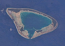
Gewässer Pazifischer Ozean Archipel Tuamotu-Archipel Geographische Lage 17° 28′ S, 143° 28′ W-17.466666666667-143.46666666667Koordinaten: 17° 28′ S, 143° 28′ W 

Anzahl der Inseln 3 Hauptinsel --- Landfläche 4 km² Lagunenfläche 10,4 km² Einwohner (unbewohnt) Haraiki ist ein Atoll im Tuamotu-Archipel in Französisch-Polynesien. Es gehört zur Gemeinde Makemo, welche aus den Atollen Makemo, Haraiki, Marutea Nord, Katiu, Tuanake, Hiti, Tepoto Süd, Raroia, Takume, Taenga und Nihiru gebildet wird. Das Atoll liegt 42 km südwestlich vom Nachbaratoll Marutea Nord entfernt. Die Lagune hat nur einen schiffbaren Zugang im Süden.
Haraiki wurde von dem spanischen Seefahrer Domingo de Boenechea am 31. Dezember 1772 entdeckt. Er nannte das Atoll „San Quintin“.
Weblinks

Ahe | Ahunui | Akiaki | Amanu | Anaa | Anuanuraro | Anuanurunga | Apataki | Aratika | Arutua | Faaite | Fakahina | Fakarava | Fangatau | Fangataufa | Gambier | Hao | Haraiki | Héréhérétué | Hikueru | Hiti | Katiu | Kauehi | Kaukura | Makatea | Makemo | Mangareva | Manihi | Manuhangi | Maria Est | Marokau | Marutea Nord | Marutea Sud | Mataiva | Matureivavao | Morane | Motutunga | Mururoa | Napuka | Nengonengo | Niau | Nihiru | Nukutavake | Nukutepipi | Paraoa | Pinaki | Puka-Puka | Puka Rua | Rangiroa | Raraka | Raroia | Ravahere | Reao | Reitoru | Rekareka | Taenga | Tahanea | Taiaro | Takapoto | Takaroa | Takume | Tatakoto | Tauere | Tekokota | Tematangi | Temoe | Tenararo | Tenarunga | Tepoto Nord | Tepoto Sud | Tikehau | Tikei | Toau | Tuanake | Tureia | Vahanga | Vahitahi | Vairaatea | Vanavana


Wikimedia Foundation.