- Fangatau
-
Synonyme:
Fangatau NASA-Bild von Fangatau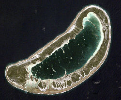
Gewässer Pazifischer Ozean Archipel Tuamotu-Archipel Geographische Lage 15° 50′ S, 140° 52′ W-15.833333333333-140.86666666667Koordinaten: 15° 50′ S, 140° 52′ W 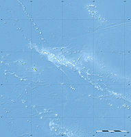

Anzahl der Inseln --- Hauptinsel --- Landfläche 6 km² Lagunenfläche 11 km² Einwohner 121 (2007) Fangatau, auch Nakai-erua genannt, ist ein kleines Atoll des Tuamotu-Archipels in Französisch-Polynesien. Das Atoll länglicher Form ist 8 km lang, 3,5 km breit und weist eine Landfläche von 6 km² auf. Die etwa 11 km² große Lagune des Atolls hat keinen Zugang zum Meer. Administrativ gehört Fangatau zur gleichnamigen Gemeinde, zu der auch das benachbarte Atoll Fakahina gehört.
Fangatau hat 121 Einwohner,[1] die vor allem den Hauptort Teana bewohnen. Das Flugfeld der Insel wurde 1978 eröffnet.
Das Atoll wurde am 10. Juli 1820 vom baltendeutschen Admiral Fabian Gottlieb von Bellingshausen entdeckt, welcher das Atoll „Arakcheev“ nannte.
Siehe auch
Weblinks
- Fangatau of oceandots.com (englisch)
Einzelnachweise
- ↑ Institut Statistique de Polynésie Française (ISPF) - Recensement de la population 2007 (PDF, franz.)

Ahe | Ahunui | Akiaki | Amanu | Anaa | Anuanuraro | Anuanurunga | Apataki | Aratika | Arutua | Faaite | Fakahina | Fakarava | Fangatau | Fangataufa | Gambier | Hao | Haraiki | Héréhérétué | Hikueru | Hiti | Katiu | Kauehi | Kaukura | Makatea | Makemo | Mangareva | Manihi | Manuhangi | Maria Est | Marokau | Marutea Nord | Marutea Sud | Mataiva | Matureivavao | Morane | Motutunga | Mururoa | Napuka | Nengonengo | Niau | Nihiru | Nukutavake | Nukutepipi | Paraoa | Pinaki | Puka-Puka | Puka Rua | Rangiroa | Raraka | Raroia | Ravahere | Reao | Reitoru | Rekareka | Taenga | Tahanea | Taiaro | Takapoto | Takaroa | Takume | Tatakoto | Tauere | Tekokota | Tematangi | Temoe | Tenararo | Tenarunga | Tepoto Nord | Tepoto Sud | Tikehau | Tikei | Toau | Tuanake | Tureia | Vahanga | Vahitahi | Vairaatea | Vanavana
Wikimedia Foundation.
Schlagen Sie auch in anderen Wörterbüchern nach:
Fangatau — Fangatau, or Nakai erua, is a small atoll in the Tuamotu group in French Polynesia. The nearest land is Fakahina Atoll, located 72 km to the ESE.This small atoll has an elongated shape. Its length is 8 km, maximum width 3.5 km. Its reef encloses… … Wikipedia
Fangatau — Vue satellite de la NASA Géographie Pays … Wikipédia en Français
Fangatau — Saltar a navegación, búsqueda Localización de Fangatau en las Tuamotu Fangatau es un atolón de las Tuamotu en la Polinesia Francesa. Está situado al este y al centro del archipiélago, a 900 km al noreste de Tahití. Es un atoló … Wikipedia Español
Fangatau (Commune) — Fangatau Administration Pays France Collectivité Polynésie française Subdivision Tuamotu Gambier Code postal Maire Mandat en cours … Wikipédia en Français
Fangatau (Gemeinde) — Fangatau ist eine Gemeinde im Tuamotu Archipel in Französisch Polynesien. Die Gemeinde besteht aus 2 Atollen. Sie ist in 2 „Communes associées“ (Teilgemeinden) untergliedert. Der Hauptort der Gemeinde ist Fangatau. Der Code INSEE der Gemeinde ist … Deutsch Wikipedia
Fangatau (commune) — 15° 49′ 12″ S 140° 53′ 14″ W / 15.819928, 140.88715 … Wikipédia en Français
Fakahina — Vorlage:Infobox Insel/Wartung/Höhe fehlt Fakahina NASA Bild von Fakahina Gewässer Pazifischer Ozean Archipel … Deutsch Wikipedia
Tuamotus — Native name: Tuamotu Flag of the Tuamotu Islands … Wikipedia
Administrative divisions of French Polynesia — French Polynesia This article is part of the series: Politics and government of French Polynesia High Commissioner Adolphe C … Wikipedia
Liste der Tuamotu-Inseln — Der Tuamotu Archipel (Französisch Polynesien) besteht aus 73 Atollen (einschl. Gambierinseln), fünf Inseln ohne Lagune (sämtlich gehobene Atolle, sowie zwei oder drei untermeerische Riffe, bei denen es sich um untergegangene Atolle handeln könnte … Deutsch Wikipedia
Fangatau


18+
© Academic, 2000-2026
- Kontaktieren Sie uns: Unterstützung, Werbung
Wörterbücher Export, schritte mit PHP, Joomla, Drupal, WordPress, MODx.