- Worcester County (Maryland)
-
Verwaltung US-Bundesstaat: Maryland Verwaltungssitz: Snow Hill Adresse des
Verwaltungssitzes:Worcester County Government
1 West Market Street
Snow Hill, MD 21863Gründung: 1742 Gebildet aus: Somerset County Vorwahl: 001 410 Demographie Einwohner: 51.454 (2010) Bevölkerungsdichte: 42 Einwohner/km² Geographie Fläche gesamt: 1.799 km² Wasserfläche: 575 km² Karte 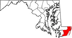
Website: www.co.worcester.md.us
Das Worcester County [1] ist das östlichste County im US-amerikanischen Bundesstaat Maryland. Bei der Volkszählung im Jahr 2010 hatte das County 51.454 Einwohner und eine Bevölkerungsdichte von 42 Einwohnern pro Quadratkilometer. Der Verwaltungssitz (County Seat) ist Snow Hill.Inhaltsverzeichnis
Geografie
Das County liegt an Atlantikküste der Delmarva-Halbinsel. Es grenzt im Norden an Delaware und im Süden an Virginia. Das Worcester County hat eine Fläche von 1.799 Quadratkilometern; davon sind 575 Quadratkilometer (33,88 Prozent) Wasserflächen. Es grenzt an folgende Countys:
Wicomico County Sussex County
(Delaware)Somerset County 
Accomack County
(Virginia)Geschichte
Das Worcester County wurde 1742 aus Teilen des Somerset County gebildet. Benannt wurde es nach dem Earl of Worcester.
Demografische Daten
Historische Einwohnerzahlen Census Einwohner ± in % 1790 11.640 — 1800 16.370 40 % 1810 16.971 4 % 1820 17.421 3 % 1830 18.273 5 % 1840 18.377 0,6 % 1850 18.859 3 % 1860 20.661 10 % 1870 16.419 -20 % 1880 19.539 20 % 1890 19.747 1 % 1900 20.865 6 % 1910 21.841 5 % 1920 22.309 2 % 1930 21.624 -3 % 1940 21.245 -2 % 1950 23.148 9 % 1960 23.733 3 % 1970 24.442 3 % 1980 30.889 30 % 1990 35.028 10 % 2000 46.543 30 % 2010 51.454 10 % vor 1900[3] 1900–1990[4] 2000[5] 2010[6] Nach der Volkszählung im Jahr 2010 lebten im Worcester County 51.454 Menschen in 22.574 Haushalten. Die Bevölkerungsdichte betrug 42 Einwohner pro Quadratkilometer.
Ethnisch betrachtet setzte sich die Bevölkerung zusammen aus 82,0 Prozent Weißen, 13,6 Prozent Afroamerikanern, 0,3 Prozent amerikanischen Ureinwohnern, 1,1 Prozent Asiaten sowie aus anderen ethnischen Gruppen; 1,7 Prozent stammten von zwei oder mehr Ethnien ab. Unabhängig von der ethnischen Zugehörigkeit waren 3,2 Prozent der Bevölkerung spanischer oder lateinamerikanischer Abstammung.
In den 22.574 Haushalten lebten statistisch je 2,16 Personen.
18,8 Prozent der Bevölkerung waren unter 18 Jahre alt, 58,2 Prozent waren zwischen 18 und 64 und 23,0 Prozent waren 65 Jahre oder älter. 51,6 Prozent der Bevölkerung war weiblich.
Das jährliche Durchschnittseinkommen eines Haushalts lag bei 47.829 USD. Das Pro - Kopf - Einkommen betrug 31.626 USD. 12,0 Prozent der Einwohner lebten unterhalb der Armutsgrenze.[8]
Städte und Gemeinden
- Pocomoke City
- Berlin
- Ocean City
- Snow Hill
Census-designated places (CDP)
- Bishopville
- Girdletree
- Newark
- Ocean Pines
- Showell
- Stockton
- West Ocean City
- Whaleyville
- Boxiron
- Cedartown
- Friendship
- Germantown
- Goodwill
- Klej Grange
- Libertytown
- Nassawango Hills
- Poplartown
- Public Landing
- Sinnepuxent
- South Point
- Taylorville
- Whiteon
Einzelnachweise
- ↑ GNIS-ID: 1668802. Abgerufen am 22. Februar 2011 (englisch).
- ↑ Auszug aus dem National Register of Historic Places - Nr. 79001148 Abgerufen am 15. September 2011
- ↑ University of Virginia Library - Historical Census Browser Abgerufen am 15. September 2011
- ↑ United States Census.gov Abgerufen am 15. September 2011
- ↑ U.S. Census Buero - United States Census 2000 für das Worcester County Abgerufen am 15. September 2011
- ↑ United States Census 2010 Abgerufen am 15. September 2011
- ↑ Auszug aus dem National Register of Historic Places - Nr. 08001013 Abgerufen am 15. September 2011
- ↑ U.S. Census Buero, State & County QuickFacts - Worcester County Abgerufen am 15. September 2011
Weblinks
-
 Commons: Worcester County, Maryland – Sammlung von Bildern, Videos und Audiodateien
 - Offizielle Webseite
- U.S. Census Buero, State & County QuickFacts - Worcester County
- Maryland State Archives - Worcester County
- Yahoo Bildersuche - Worcester County
- www.city-data.com - Worcester County

Liste der Countys in Maryland
Allegany | Anne Arundel | Baltimore City | Baltimore | Calvert | Caroline | Carroll | Cecil | Charles | Dorchester | Frederick | Garrett | Harford | Howard | Kent | Montgomery | Prince George’s | Queen Anne’s | Saint Mary's | Somerset | Talbot | Washington | Wicomico | Worcester
Wikimedia Foundation.
Schlagen Sie auch in anderen Wörterbüchern nach:
Worcester County, Maryland — Seal … Wikipedia
National Register of Historic Places listings in Worcester County, Maryland — Location of Worcester County in Maryland This is a list of the National Register of Historic Places listings in Worcester County, Maryland. This is intended to be a complete list of the properties and districts on the National Register of… … Wikipedia
Germantown, Worcester County, Maryland — Germantown is an unincorporated community in Worcester County, Maryland. It is located at coord|38|18|30|N|75|12|36|W| … Wikipedia
Worcester County Public Schools — is a public school district within Worcester County, Maryland.Elementary Schools* Buckingham Elementary School * Ocean City Elementary School * Pocomoke Elementary School * Showell Elementary School * Snow Hill Elementary SchoolMiddle Schools*… … Wikipedia
Worcester County — is the name of two counties in the United States of America: *Worcester County, Maryland *Worcester County, Massachusetts … Wikipedia
Worcester County District Courthouses — The District Court of Maryland for Wocester County District Courthouses are located in Ocean City and Snow Hill and serve as the courts of first impression for the majority of residents in Worcester County, Maryland. All minor traffic and most… … Wikipedia
Worcester County Sheriff's Office — The Worcester County Sheriff s Office (WCSO) is the primary law enforcement agency servicing a population of 46,543 residents in 473 square miles of Worcester County, Maryland. [ [http://www.co.worcester.md.us/maps/factsata.htm Facts at a Glance … Wikipedia
Worcester County — Es gibt in den Vereinigten Staaten zwei Countys mit dem Namen Worcester County: Worcester County (Maryland) Worcester County (Massachusetts) Diese Seite ist eine Begriffsklärung zur Unterscheidung mehrerer mit demselben Wort bezei … Deutsch Wikipedia
Providence County (Maryland) — Verwaltung US Bundesstaat: Maryland Verwaltungssitz: Annapolis Adresse des Verwaltungssitzes: Gründung … Deutsch Wikipedia
Baltimore County (Maryland) — Verwaltung US Bundesstaat: Maryland Verwaltungssitz: Towson Adresse des Verwaltungssitzes: Gründung … Deutsch Wikipedia
Worcester County (Maryland)


18+
© Academic, 2000-2026
- Kontaktieren Sie uns: Unterstützung, Werbung
Wörterbücher Export, schritte mit PHP, Joomla, Drupal, WordPress, MODx.