- Anne Arundel County
-
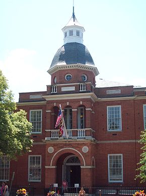
Verwaltung US-Bundesstaat: Maryland Verwaltungssitz: Annapolis Adresse des
Verwaltungssitzes:Anne Arundel County Courthouse
44 Calvert Street
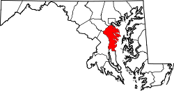
Annapolis, MD 21401Gründung: 1650 Gebildet aus: unorganisiertem Gebiet Vorwahl: 001 410 Demographie Einwohner: 537.656 (2010) Bevölkerungsdichte: 498,8 Einwohner/km² Geographie Fläche gesamt: 1.523 km² Wasserfläche: 445 km² Karte Website: www.aacounty.org Das Anna Arundel County[1] ist ein County im Bundesstaat Maryland der Vereinigten Staaten von Amerika. Bei der Volkszählung im Jahr 2010 hatte das County 537.656 Einwohner und eine Bevölkerungsdichte von 498,8 Einwohnern pro Quadratkilometer. Der Sitz der Countyverwaltung (County Seat) und Hauptstadt Marylands ist Annapolis.
Inhaltsverzeichnis
Geografie
Das County liegt am Westufer der Chesapeake Bay und grenzt im Norden an die Stadt Baltimore an. Das Anne Arundel County hat eine Fläche von 1.523 Quadratkilometern; davon sind 445 Quadratkilometer (29,25 Prozent) Wasserflächen. Es grenzt an folgende Countys:
Howard County Baltimore County,
Baltimore CityKent County 
Queen Anne’s County Prince George’s County Calvert County Talbot County Geschichte
Das County wurde im Jahre 1650 aus unorganisiertem Territorium gebildet. Von 1654 bis 1658 hieß das County Providence County. 1658 wurde das County nach Anne Arundel benannt, der Ehefrau von Cecilius Calvert (2nd Baron Baltimore), dem ersten Inhaber der Kolonie Provinz Maryland.
Historische Objekte
- In Annapolis steht abseits der St. Margaret's Road das historische Whitehall. Das Anwesen des ehemaligen Gouverneurs Horatio Sharpe wurde am 15. Oktober 1966 vom National Register of Historic Places als historisches Denkmal mit der Nummer 66000387 aufgenommen. Ebenso wurde es im National Historic Landmark eingeschrieben.[2][3]
- Etwa vier Kilometer westlich von Galesville, befindet sich die historisch relevante Tulip Hill-Plantage. Das zwischen 1755 und 1756 errichtete Anwesen, wurde am 15. April 1970 vom NRHP mit der Nummer 70000261 aufgenommen.[4]
Demografische Daten
Historische Einwohnerzahlen Census Einwohner ± in % 1900 39.620 — 1910 39.553 -0,2 % 1920 43.408 10 % 1930 55.167 30 % 1940 68.375 20 % 1950 117.392 70 % 1960 206.634 80 % 1970 297.539 40 % 1980 370.775 20 % 1990 427.239 20 % 2000 489.565 10 % 2010 537.656 10 % 1900–1990[5] 2010[6] Nach der Volkszählung im Jahr 2000 lebten im Anne Arundel County 489.656 Menschen in 178.670 Haushalten und 129.178 Familien. Die Bevölkerungsdichte betrug 455 Personen pro Quadratkilometer. Ethnisch betrachtet setzte sich die Bevölkerung zusammen aus 81,24 Prozent Weißen, 13,57 Prozent Afroamerikanern, 0,30 Prozent amerikanischen Ureinwohnern, 2,29 Prozent Asiaten und 0,93 Prozent aus anderen ethnischen Gruppen; 1,69 Prozent stammten von zwei oder mehr Ethnien ab. Unabhängig von der ethnischen Zugehörigkeit waren 2,63 Prozent der Bevölkerung spanischer oder lateinamerikanischer Abstammung.
Von den 178,670 Haushalten hatten 34,9 Prozent Kinder unter 18 Jahren, die mit ihnen lebten. 57,2 Prozent waren verheiratete, zusammenlebende Paare, 11,1 Prozent waren allein erziehende Mütter und 27,7 Prozent waren keine Familien. 21,3 Prozent aller Haushalte waren Singlehaushalte und in 6,4 Prozent lebten Menschen im Alter von 65 Jahren oder darüber. Die durchschnittliche Haushaltsgröße lag bei 2,65 und die durchschnittliche Familiengröße bei 3,09 Personen.
25,2 Prozent der Bevölkerung war unter 18 Jahre alt, 8,1 Prozent zwischen 18 und 24, 32,8 Prozent zwischen 25 und 44, 23,9 Prozent zwischen 45 und 64 Jahre alt und 10,0 Prozent waren 65 Jahre oder älter. Das Durchschnittsalter betrug 36 Jahre. Auf 100 weibliche kamen statistisch 99,1 männliche Personen und auf 100 Frauen im Alter von 18 Jahren oder darüber kamen 97,1 Männer.
Das durchschnittliche Einkommen eines Haushaltes betrug 61.768 USD, das einer Familie 69.019 USD. Männer hatten ein durchschnittliches Einkommen von 43.747 USD, Frauen 32.348 USD. Das Pro-Kopf-Einkommen lag bei 27.578 USD. Etwa 3,6 Prozent der Familien und 5,1 Prozent der Bevölkerung lebten unterhalb der Armutsgrenze.[7]
Städte und Gemeinden
- Highland Beach
Census-designated places (CDP)- Arden on the Severn
- Arnold
- Brooklyn Park
- Cape Saint Claire
- Crofton
- Crownsville
- Deale
- Ferndale
- Fort George G. Meade
- Fort Meade
- Glen Burnie
- Green Haven
- Hanover
- Herald Harbor
- Hillsmere Shores
- Jessup1
- Lake Shore
- Linthicum
- Londontowne
- Maryland City
- Mayo
- Odenton
- Parole
- Pasadena
- Pumphrey
- Riva
- Riviera Beach
- Selby-on-the-Bay
- Severn
- Severna Park
- Shady Side
- South Gate
1 - teilweise im Howard County
Fort George G. Meade, der Sitz der NSA, liegt im Anne Arundel County.
Einzelnachweise
- ↑ GNIS-ID: 1710958. Abgerufen am 22. Februar 2011 (englisch).
- ↑ NRIS
- ↑ National Historic Landmarks Program (Whitehall)
- ↑ Historic Tulip Hill circa 1756
- ↑ United States Census.gov Abgerufen am 18. Februar 2011
- ↑ United States Census 2010 Abgerufen am 29. Juni 2011
- ↑ Anne Arundel County, Maryland Datenblatt mit den Ergebnissen der Volkszählung im Jahre 2000 bei factfinder.census.gov
Weblinks
-
 Commons: Anne Arundel County, Maryland – Sammlung von Bildern, Videos und Audiodateien
 - Offizielle Webseite
- Maryland State Archives - Anne Arundel County
- www.city-data.com
Liste der Countys in Maryland
Allegany | Anne Arundel | Baltimore City | Baltimore | Calvert | Caroline | Carroll | Cecil | Charles | Dorchester | Frederick | Garrett | Harford | Howard | Kent | Montgomery | Prince George’s | Queen Anne’s | Saint Mary's | Somerset | Talbot | Washington | Wicomico | Worcester
Wikimedia Foundation.
Schlagen Sie auch in anderen Wörterbüchern nach:
Anne Arundel County — Admin ASC 2 Code Orig. name Anne Arundel County Country and Admin Code US.MD.003 US … World countries Adminstrative division ASC I-II
Anne Arundel County Public Schools — is the public school district serving Anne Arundel County, Maryland. The AACPS school system is the 5th largest in Maryland,[citation needed] and the 46th largest in the United States.[citation needed] The district has over 5,000 teachers… … Wikipedia
Anne Arundel County Department of Recreation and Parks — is primarily responsible for the provision of a comprehensive system of recreational programs for county residents and the preservation of valuable land in the form of more than 140 parks and sanctuaries. Specialized recreational facilities,… … Wikipedia
Anne Arundel County, Maryland — Infobox U.S. County county = Anne Arundel County state = Maryland map size = 225 founded year = 1650 seat wl = Annapolis | largest city wl = Glen Burnie leader = Janet S. Owens area total sq mi =588 area land sq mi =416 area water sq mi =172 area … Wikipedia
Anne Arundel County (Maryland) — Verwaltung US Bundesstaat: Maryland Verwaltungssitz: Annapolis Adresse des Verwaltungssitzes: Gründung … Deutsch Wikipedia
Anne Arundel County Police Department — The Anne Arundel County Police Department is the primary law enforcement agency of Anne Arundel County, Maryland. The Department was created by an Act of the Maryland General Assembly in 1937, and consisted of a Chief of Police, three sergeants,… … Wikipedia
Anne Arundel County Sheriff's Office — The Anne Arundel County Sheriff s Office (AASO) is the law enforcement arm of the court, servicing the citizens of Anne Arundel County, Maryland. All deputy sheriffs are certified law enforcement officials with full authority of arrest.HistoryThe … Wikipedia
Anne Arundel County Delegation — if you have information that can be referenced with a , please, feel free to help! Expand section|date=June 2008 The Anne Arundel County Delegation refers to the members of the Maryland House of Delegates who reside in or represent legislative… … Wikipedia
National Register of Historic Places listings in Anne Arundel County, Maryland — Location of Anne Arundel County in Maryland This is a list of the National Register of Historic Places listings in Anne Arundel County, Maryland. This is intended to be a complete list of the properties and districts on the National Register of… … Wikipedia
Chesapeake High School, Anne Arundel County — Infobox Secondary school name = Chesapeake Senior High School established = 1976 type = Public Secondary principal = Patricia Plitt students = 1,908 grades = 9–12 city = Pasadena state = Maryland, country = USA district = Anne Arundel County… … Wikipedia


