- Carroll County (Maryland)
-
Verwaltung US-Bundesstaat: Maryland Verwaltungssitz: Westminster Adresse des
Verwaltungssitzes:Carroll County Office Building
225 North Center Street
Westminster, MD 21157Gründung: 1837 Gebildet aus: Baltimore und Frederick County Vorwahl: 001 410 Demographie Einwohner: 167.134 (2010) Bevölkerungsdichte: 143,6 Einwohner/km² Geographie Fläche gesamt: 1.172 km² Wasserfläche: 8 km² Karte 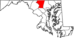
Website: www.carr.org Das Carroll County[1] ist ein County im Bundesstaat Maryland der Vereinigten Staaten von Amerika. Bei der Volkszählung im Jahr 2010 hatte das County 167.134 Einwohner und eine Bevölkerungsdichte von 143,6 Einwohnern pro Quadratkilometer. Der Verwaltungssitz (County Seat) ist Westminster.
Inhaltsverzeichnis
Geografie
Das County wird im Norden durch die Mason-Dixon-Linie von Pennsylvania getrennt. Es hat eine Fläche von 1.172 Quadratkilometern; davon sind 8 Quadratkilometer (0,72 Prozent) Wasserflächen. Angrenzende Countys sind:
Adams County
(Pennsylvania)York County
(Pennsylvania)Frederick County 
Baltimore County Howard County Geschichte
 C. Carroll
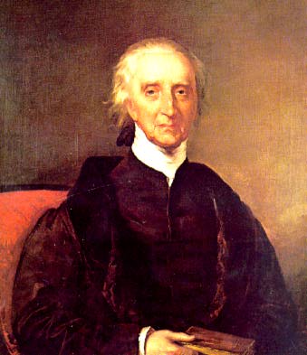
Das Carroll County wurde 1837 aus Teilen des Baltimore und des Frederick Countys gebildet. Benannt wurde es nach Charles Carroll (1737-1832), einem der Gründerväter der USA.
Demografische Daten
Historische Einwohnerzahlen Census Einwohner ± in % 1840 17.241 — 1850 20.616 20 % 1860 24.533 20 % 1870 28.619 20 % 1880 30.992 8 % 1890 32.376 4 % 1900 33.860 5 % 1910 33.934 0,2 % 1920 33.934 0 % 1930 35.978 6 % 1940 39.054 9 % 1950 44.907 10 % 1960 52.785 20 % 1970 69.006 30 % 1980 96.356 40 % 1990 123.372 30 % 2000 150.897 20 % 2010 167.134 10 % vor 1900[2] 1900–1990[3] 2000[4] 2010[5] Nach der Volkszählung im Jahr 2000 lebten im Anne Arundel County 150.897 Menschen in 52.503 Haushalten und 41.109 Familien. Die Bevölkerungsdichte betrug 336 Personen pro Quadratkilometer. Ethnisch betrachtet setzte sich die Bevölkerung zusammen aus 95,7 Prozent Weißen, 2,3 Prozent Afroamerikanern, 0,2 Prozent amerikanischen Ureinwohnern, 0,8 Prozent Asiaten und 0,3 Prozent aus anderen ethnischen Gruppen; 0,7 Prozent stammten von zwei oder mehr Ethnien ab. Unabhängig von der ethnischen Zugehörigkeit waren 1,0 Prozent der Bevölkerung spanischer oder lateinamerikanischer Abstammung.
Von den 52.503 Haushalten hatten 39,7 Prozent Kinder unter 18 Jahren, die mit ihnen lebten. 66,5 Prozent waren verheiratete, zusammenlebende Paare, 8,3 Prozent waren allein erziehende Mütter und 21,7 Prozent waren keine Familien. 17,5 Prozent aller Haushalte waren Singlehaushalte und in 7,4 Prozent lebten Menschen im Alter von 65 Jahren oder darüber. Die durchschnittliche Haushaltsgröße lag bei 2,81 und die durchschnittliche Familiengröße bei 3,18 Personen.
27,7 Prozent der Bevölkerung war unter 18 Jahre alt, 7,0 Prozent zwischen 18 und 24, 30,6 Prozent zwischen 25 und 44, 23,9 Prozent zwischen 45 und 64 Jahre alt und 10,8 Prozent waren 65 Jahre oder älter. Das Durchschnittsalter betrug 37 Jahre. Auf 100 weibliche kamen statistisch 97,4 männliche Personen und auf 100 Frauen im Alter von 18 Jahren oder darüber kamen 94 Männer.
Das durchschnittliche Einkommen eines Haushaltes betrug 60.021 USD, das einer Familie 66.430 USD. Männer hatten ein durchschnittliches Einkommen von 44.191 USD, Frauen 30.599 USD. Das Pro-Kopf-Einkommen lag bei 23.829 USD. Etwa 2,7 Prozent der Familien und 3,8 Prozent der Bevölkerung lebten unterhalb der Armutsgrenze.[6]
Städte und Gemeinden
- Westminster
- Taneytown
- Manchester
- New Windsor
- Union Bridge
- Hampstead
- Mount Airy1
- Sykesville
- Eldersburg
- Alesia
- Carrollton
- Carrolltowne
- Detour
- Finksburg
- Frizzelburg
- Gamber
- Gaither
- Greenmount
- Harney
- Henryton
- Jasontown
- Keymar
- Lineboro
- Linwood
- Louisville
- Marriottsville2
- Middleburg
- Millers
- Patapsco
- Pleasant Valley
- Silver Run
- Union Mills
- Uniontown
- Woodbine2
- Woodstock3
1 - teilweise im Frederick, Howard und im Montgomery County
2 - teilweise im Howard County
3 - teilweise im Howard und im Baltimore CountyEinzelnachweise
- ↑ GNIS-ID: 1696228. Abgerufen am 22. Februar 2011 (englisch).
- ↑ University of Virginia Library - Historical Census Browser Abgerufen am 1. Juli 2011
- ↑ United States Census.gov Abgerufen am 1. Juli 2011
- ↑ U.S. Census Buero - United States Census 2000 für das Carroll County Abgerufen am 1. Juli 2011
- ↑ United States Census 2010 Abgerufen am 1. Juli 2011
- ↑ Carroll County, Maryland Datenblatt mit den Ergebnissen der Volkszählung im Jahre 2000 bei factfinder.census.gov
Weblinks
-
 Commons: Carroll County, Maryland – Sammlung von Bildern, Videos und Audiodateien
 - Offizielle Webseite
- Handelskammer des Carroll Çounty
- Maryland State Archives - Carroll County
- Carroll County Visitor Center
- www.city-data.com

Liste der Countys in Maryland
Allegany | Anne Arundel | Baltimore City | Baltimore | Calvert | Caroline | Carroll | Cecil | Charles | Dorchester | Frederick | Garrett | Harford | Howard | Kent | Montgomery | Prince George’s | Queen Anne’s | Saint Mary's | Somerset | Talbot | Washington | Wicomico | Worcester
Wikimedia Foundation.
Schlagen Sie auch in anderen Wörterbüchern nach:
Carroll County, Maryland — Infobox U.S. County county = Carroll County state = Maryland map size = 225 founded year = 1837 seat wl = Westminster | largest city wl = Eldersburg city type = CDP area total sq mi =452 area land sq mi =449 area water sq mi =3 area percentage =… … Wikipedia
National Register of Historic Places listings in Carroll County, Maryland — Location of Carroll County in Maryland This is a list of the National Register of Historic Places listings in Carroll County, Maryland. This is intended to be a complete list of the properties and districts on the National Register of Historic… … Wikipedia
Liberty High School (Carroll County, Maryland) — For schools with similar names, see Liberty High School. Liberty High School Motto Strive for Excellence Established 1980 … Wikipedia
Mexico, Carroll County, Maryland — Coordinates: 39°36′03″N 76°56′40″W / 39.60083°N 76.94444°W / 39.60083; 76.94444 Mexico is an unincorporate … Wikipedia
List of roads in Carroll County, Maryland — Contents B · C · D · E · F · G · H · L · M · N · O · … Wikipedia
Liberty High School, Carroll County, Maryland — Liberty High School (LHS) is a four year public high school in Eldersburg in Carroll County, Maryland, United States at 5855 Bartholow Road. The current Principal of the school is Dwayne Piper.About the SchoolLiberty High School was established… … Wikipedia
Carroll County Public Schools (Maryland) — Carroll County Public Schools is a school district based in Westminster, Maryland. CCPS is the ninth largest in the state of Maryland. More than 27,000 students are enrolled in the county s public schools. The school system includes all of… … Wikipedia
Carroll County — is the name of thirteen counties in the United States of America. All except Carroll County, Tennessee, are named for Charles Carroll of Carrollton, a signer of the United States Declaration of Independence from Maryland: Carroll County, Arkansas … Wikipedia
Carroll County — Es gibt in den Vereinigte Staaten 13 Countys mit dem Namen Carroll County. Mit Ausnahme des Countys in Tennessee wurden alle nach Charles Carroll benannt. Carroll County (Arkansas) Carroll County (Georgia) Carroll County (Illinois) Carroll County … Deutsch Wikipedia
Carroll County (Illinois) — Carroll County Courthouse in Mount Carroll, gelistet im NRHP Nr. 73000692[1] Verwaltung … Deutsch Wikipedia
Carroll County (Maryland)


18+
© Academic, 2000-2026
- Kontaktieren Sie uns: Unterstützung, Werbung
Wörterbücher Export, schritte mit PHP, Joomla, Drupal, WordPress, MODx.