- Kent County (Maryland)
-
Verwaltung US-Bundesstaat: Maryland Verwaltungssitz: Chestertown Adresse des
Verwaltungssitzes:Kent County Government Center
400 High Street
Chestertown, MD 21620Gründung: 1642 Gebildet aus: Indianerland Vorwahl: 001 410 Demographie Einwohner: 20.197 (2010) Bevölkerungsdichte: 27,9 Einwohner/km² Geographie Fläche gesamt: 1.073 km² Wasserfläche: 349 km² Karte 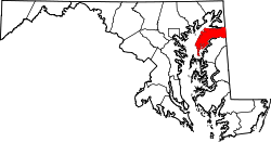
Das Kent County[1] ist ein County im US-amerikanischen Bundesstaat Maryland. Bei der Volkszählung im Jahr 2010 hatte das County 20.197 Einwohner und eine Bevölkerungsdichte von 27,9 Einwohnern pro Quadratkilometer. Damit ist es das County mit der niedrigsten Bevölkerungszahl in Maryland. Der Verwaltungssitz (County Seat) ist Chestertown.
Inhaltsverzeichnis
Geografie
Das County liegt im Nordwesten der Delmarva-Halbinsel am östlichen Ufer der Chesapeake Bay und grenzt im Osten an Delaware. Es hat eine Fläche von 1.073 Quadratkilometern; davon sind 349 Quadratkilometer (32,55 Prozent) Wasserflächen. Folgende Countys grenzen an das Kent County:
Cecil County New Castle County
(Delaware)
Queen Anne's County Kent County
(Delaware)Geschichte
Das County wurde 1642 aus ehemaligem Indianerland gebildet und nach der Grafschaft Kent in England benannt.
Demografische Daten
Historische Einwohnerzahlen Census Einwohner ± in % 1790 12.836 — 1800 11.771 -8 % 1810 11.450 -3 % 1820 11.453 0,03 % 1830 10.501 -8 % 1840 10.842 3 % 1850 11.386 5 % 1860 13.267 20 % 1870 17.102 30 % 1880 17.605 3 % 1890 17.471 -0,8 % 1900 18.786 8 % 1910 16.957 -10 % 1920 15.026 -10 % 1930 14.242 -5 % 1940 13.465 -5 % 1950 13.677 2 % 1960 15.481 10 % 1970 16.146 4 % 1980 16.695 3 % 1990 17.842 7 % 2000 19.197 8 % 2010 20.197 5 % vor 1900[2] 1900–1990[3] 2000[4] 2010[5] Nach der Volkszählung im Jahr 2010 lebten im Kent County 20.197 Menschen in 8.071 Haushalten. Die Bevölkerungsdichte betrug 27,9 Einwohner pro Quadratkilometer.
Ethnisch betrachtet setzte sich die Bevölkerung zusammen aus 80,1 Prozent Weißen, 15,1 Prozent Afroamerikanern, 0,2 Prozent amerikanischen Ureinwohnern, 0,8 Prozent Asiaten sowie aus anderen ethnischen Gruppen; 1,8 Prozent stammten von zwei oder mehr Ethnien ab. Unabhängig von der ethnischen Zugehörigkeit waren 4,5 Prozent der Bevölkerung spanischer oder lateinamerikanischer Abstammung.
In den 8.071 Haushalten lebten statistisch je 2,28 Personen.
18,0 Prozent der Bevölkerung waren unter 18 Jahre alt, 61,8 Prozent waren zwischen 19 und 64 und 20,2 Prozent waren 65 Jahre oder älter. 52,4 Prozent der Bevölkerung war weiblich.
Das jährliche Durchschnittseinkommen eines Haushalts lag bei 50.585 USD. Das Pro - Kopf - Einkommen betrug 29.262 USD. 14,4 Prozent der Einwohner lebten unterhalb der Armutsgrenze.[6]
Städte und Gemeinden
- Betterton
- Chestertown
- Galena
- Millington1
- Rock Hall
- Fairlee
- Georgetown
- Lynch
- Kennedyville
- Massey
- Still Pond
- Tolchester
- Worton
1 - teilweise im Queen Anne’s County
Einzelnachweise
- ↑ GNIS-ID: 593907. Abgerufen am 22. Februar 2011 (englisch).
- ↑ University of Virginia Library - Historical Census Browser Abgerufen am 4. September 2011
- ↑ United States Census.gov Abgerufen am 4. September 2011
- ↑ U.S. Census Buero - United States Census 2000 für das Kent County Abgerufen am 4. September 2011
- ↑ United States Census 2010 Abgerufen am 4. September 2011
- ↑ U.S. Census Buero, State & County QuickFacts - Kent County Abgerufen am 4. September 2011
Weblinks
-
 Commons: Kent County, Maryland – Sammlung von Bildern, Videos und Audiodateien
 - Kent County Tourism and Economic Development Office
- U.S. Census Buero, State & County QuickFacts - Kent County
- Maryland State Archives - Kent County
- Yahoo Bildersuche - Kent County
- www.city-data.com - Kent County

Liste der Countys in Maryland
Allegany | Anne Arundel | Baltimore City | Baltimore | Calvert | Caroline | Carroll | Cecil | Charles | Dorchester | Frederick | Garrett | Harford | Howard | Kent | Montgomery | Prince George’s | Queen Anne’s | Saint Mary's | Somerset | Talbot | Washington | Wicomico | Worcester
Wikimedia Foundation.
Schlagen Sie auch in anderen Wörterbüchern nach:
Kent County, Maryland — Infobox U.S. County county = Kent County state = Maryland map size = 225 founded year = 1642 seat wl = Chestertown | area total sq mi =414 area land sq mi =279 area water sq mi =135 area percentage = 32.55% census yr = 2000 pop = 19197 density… … Wikipedia
National Register of Historic Places listings in Kent County, Maryland — Location of Kent County in Maryland This is a list of the National Register of Historic Places listings in Kent County, Maryland. This is intended to be a complete list of the properties and districts on the National Register of Historic Places… … Wikipedia
Kent County, Delaware — The Kent County Courthouse in Dover in 2006 … Wikipedia
Kent County — is the name of several counties in the United States and Canada:* Kent County, Delaware * Kent County, Maryland * Kent County, Michigan * Kent County, Rhode Island * Kent County, Texas * Kent County, New Brunswick * Kent County, Ontario* Kent is… … Wikipedia
Kent County — gibt es mehrfach in den USA: Kent County (Delaware) Kent County (Maryland) Kent County (Michigan) Kent County (Rhode Island) Kent County (Texas) Sowie in Kanada: Kent County (New Brunswick) Kent County (Ontario), 1998 mit Chatham zur Gemeinde… … Deutsch Wikipedia
Kent Island, Maryland — Kent Island is the largest island in the Chesapeake Bay, and a historic place in Maryland. To the east, a narrow channel known as the Kent Narrows barely separates the island from the Delmarva Peninsula, and on the other side, the island is… … Wikipedia
Kent County (Delaware) — Das Kent County Courthouse in Dover Verwaltung US Bundesstaat: Delaware … Deutsch Wikipedia
Kent Narrows, Maryland — This article is about the community, for the body of water see Kent Narrows Infobox Settlement official name = Kent Narrows, Maryland settlement type = CDP nickname = motto = imagesize = image caption = image imagesize = image caption = image… … Wikipedia
Providence County (Maryland) — Verwaltung US Bundesstaat: Maryland Verwaltungssitz: Annapolis Adresse des Verwaltungssitzes: Gründung … Deutsch Wikipedia
Baltimore County (Maryland) — Verwaltung US Bundesstaat: Maryland Verwaltungssitz: Towson Adresse des Verwaltungssitzes: Gründung … Deutsch Wikipedia
Kent County (Maryland)


18+
© Academic, 2000-2026
- Kontaktieren Sie uns: Unterstützung, Werbung
Wörterbücher Export, schritte mit PHP, Joomla, Drupal, WordPress, MODx.