- GB-SAY
-
South Ayrshire
Siorrachd Inbhir Àir a Deas
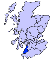
Verwaltungssitz Ayr Fläche 1.222 km² (15.) Einwohner (2005) 111.780 (17.) ISO 3166-2 GB-SAY ONS-Code 00RE Website www.south-ayrshire.gov.uk South Ayrshire (gälisch Siorrachd Inbhir Àir a Deas) ist eine von 32 unitary authorities in Schottland. Sie umfasst den südlichen Teil der traditionellen Grafschaft Ayrshire und grenzt an East Ayrshire sowie Dumfries and Galloway
Inhaltsverzeichnis
Orte
- Alloway
- Ayr
- Ballantrae
- Crosshill
- Dailly
- Dalrymple
- Girvan
- Kirkoswald
- Lendalfoo
- Maybole
- Monkton
- Prestwick
- Tarbolton
- Troon
- Turnberry
Sehenswürdigkeiten
- Bargany Gardens
- Burns Cottage
- Burns National Heritage Park
- Carrick Forest
- Crossraguel Abbey
- Culzean Castle
- Souter Johnnie's Cottage
Politik
Der Council von South Ayrshire umfasst 30 Sitze, die sich wie folgt auf die Parteien verteilen:[1]
Partei Sitze Scottish Conservatives 12 Scottish National Party 8 Scottish Labour 8 Unabhängig 2 Quellen
- ↑ South Ayrshire Council: http://www.south-ayrshire.gov.uk/council/wards/index.htm Councillors (Abgerufen am 14.4.2008)
Aberdeen | Aberdeenshire | Angus | Argyll and Bute | Clackmannanshire | Dumfries and Galloway | Dundee | East Ayrshire | East Dunbartonshire | East Lothian | East Renfrewshire | Edinburgh | Falkirk | Fife | Glasgow | Highland | Inverclyde | Midlothian | Moray | Äußere Hebriden | North Ayrshire | North Lanarkshire | Orkney | Perth and Kinross | Renfrewshire | Scottish Borders | Shetland | South Ayrshire | South Lanarkshire | Stirling | West Dunbartonshire | West Lothian
Wikimedia Foundation.
