- Kentish Town
-
London Borough of Camden 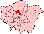
Lage in Greater LondonStatus London Borough Region Greater London Verwaltungssitz St Pancras Fläche 21,80 km² (345.) Einwohner (2007) 231.900 (48.) ONS-Code 00AG Website www.camden.gov.uk London Borough of Camden [ˈkæmdən] ist ein Stadtbezirk von London. Er liegt unmittelbar nördlich des Stadtzentrums und reicht bis zum Hampstead Heath. Bei der Gründung von Greater London im Jahr 1965 ersetzte er die Bezirke Hampstead, Holborn und St Pancras der ehemaligen County of London.
Die Bevölkerung setzt sich folgendermaßen zusammen: 73,2 % Weiße, 10,4 % Südasiaten (vor allem aus Bangladesch), 8,3 % Schwarze und 1,8 % Chinesen.
Inhaltsverzeichnis
Stadtteile
- Bloomsbury
- Camden Town
- Dartmouth Park
- Fortune Green
- Fitzrovia
- Gospel Oak
- Hampstead
- Highgate
- Holborn
- Kentish Town
- Kilburn
- Kings Cross
- Primrose Hill
- Somers Town
- South Hampstead
- St Pancras
- Swiss Cottage
- West Hampstead
Tourismus
In Hampstead befindet sich mit dem Pfadfinderinnenzentrum Pax Lodge eines der vier Weltzentren der World Association of Girl Guides and Girl Scouts. Gleich neben Pax Lodge liegt der Hauptsitz des Weltverbandes WAGGGS. Gegründet wurde die WAGGGS 1928 von Olave Baden-Powell, Ehefrau von Robert Baden-Powell dem Begründer der Pfadfinderbewegung.
Sehenswürdigkeiten
- British Library
- British Museum
- Camden Market
- Freud Museum (London)
- Hampstead Heath
- die Bahnhöfe King’s Cross, St Pancras und Euston
- der östliche Teil des Regent’s Park
- Highgate Cemetery
Persönlichkeiten
- Frank Auerbach - Maler
- Bloomsbury Group – eine Vereinigung von Wissenschaftlern und Künstlern, die von 1905 bis zum Zweiten Weltkrieg existierte.
- Dirk Bogarde - Schauspieler und Schriftsteller
- Christian John Storey Bonington - Bergsteiger
- Samuel Taylor Coleridge - Dichter und Philosoph
- Graham Coxon - Sänger und Gitarrist (Ex-Blur)
- Thomas Dunhill - Komponist
- Sigmund Freud Begründer der Psychoanalyse
- Stephen Fry, Schauspieler
- Graham Hill - Rennfahrer
- Frank Holl - Maler
- Saul Hudson (Slash), geb. 1965 - US- Gitarrist (Ex-Guns N’ Roses)
- Jens Lehmann - Fußball-Torwart
- Shane MacGowan - Sänger und Musiker (The Pogues)
- George Michael - Sänger
- Dax O'Callaghan - Choreograph, Sänger, Tänzer und Schauspieler
- Sylvia Plath - Schriftstellerin
- Ridley Scott, Regisseur, Produzent
- Jerry Springer, geb. 1944; US- Politiker und Moderator
- Dusty Springfield - Sängerin
- Rod Stewart - Popsänger
- Charles Tanqueray - Ginhersteller
- Neil Tennant, geb. 1953; singende Hälfte der Pet Shop Boys
- Peter Ustinov - Schriftsteller, Schauspieler, Regisseur
- Alain Whyte - Gitarrist
- Amy Winehouse - Sängerin
- Lawson Wood - Maler, Illustrator und Karikaturist
Weblinks
- Camden Borough Council (Bezirksverwaltung)
- Camden Town Online
Stadtbezirke von LondonBarking and Dagenham | Barnet | Bexley | Brent | Bromley | Camden | City of London | City of Westminster | Croydon | Ealing | Enfield | Greenwich | Hackney | Hammersmith and Fulham | Haringey | Harrow | Havering | Hillingdon | Hounslow | Islington | Kensington and Chelsea | Kingston | Lambeth | Lewisham | Merton | Newham | Redbridge | Richmond | Southwark | Sutton | Tower Hamlets | Waltham Forest | Wandsworth
Sonstige Einteilung: Greater London | Inner London | Outer London | County of London

Wikimedia Foundation.