- Racine County
-
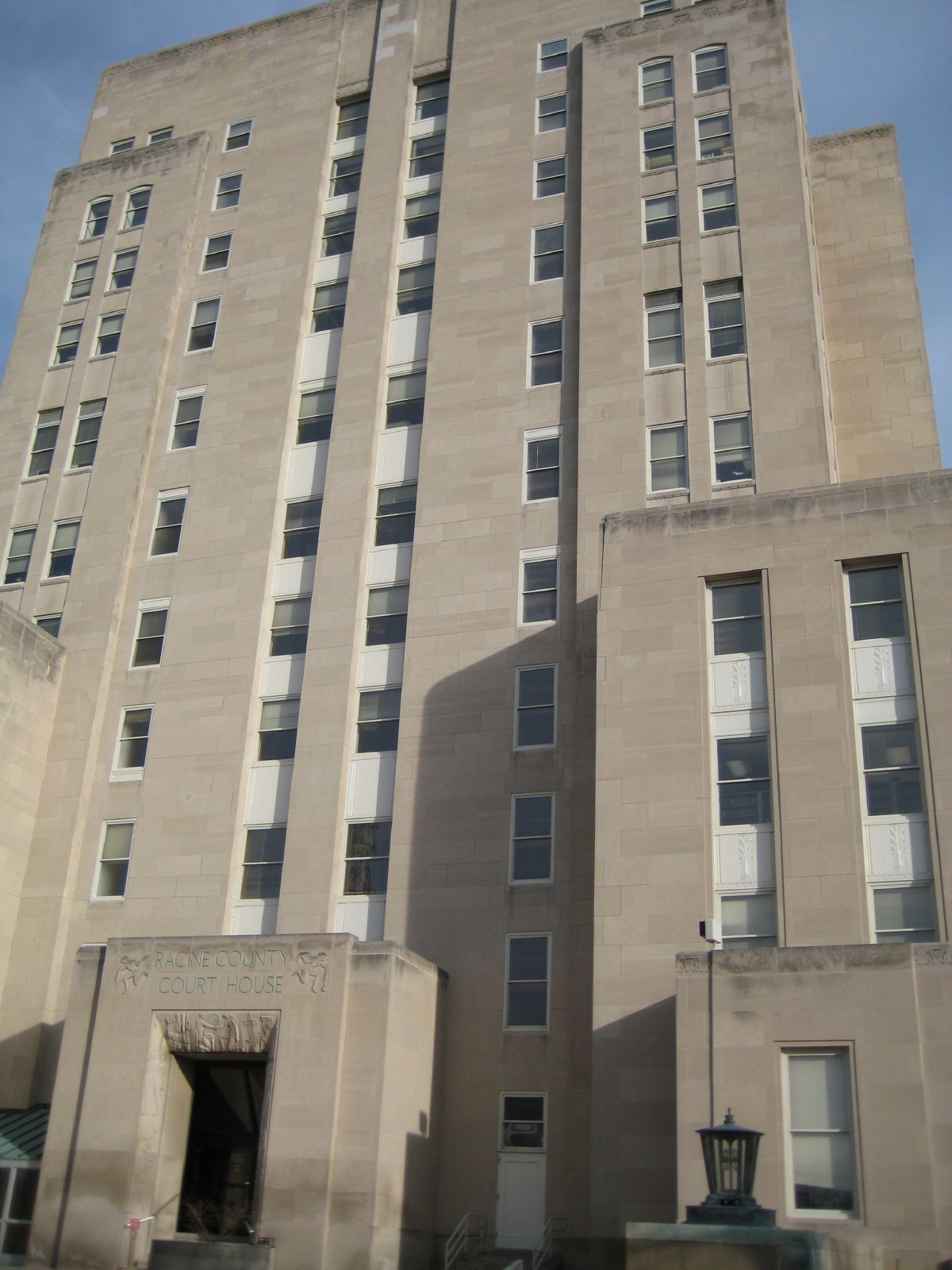
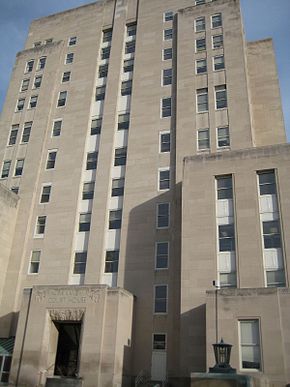 Das Racine County Courthouse in Racine
Verwaltung US-Bundesstaat: Wisconsin Verwaltungssitz: Racine Adresse des
Verwaltungssitzes:County Courthouse
730 Wisconsin Avenue
Racine, WI 53403-1238Gründung: 1836 Gebildet aus: Original-County Vorwahl: 001 262 Demographie Einwohner: 195.408 (2010) Bevölkerungsdichte: 226,4 Einwohner/km² Geographie Fläche gesamt: 2.051 km² Wasserfläche: 1.188 km² Karte 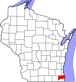
Website: www.racineco.com Das Racine County[1] ist ein County im Bundesstaat Wisconsin der Vereinigten Staaten von Amerika. Bei der Volkszählung im Jahr 2010 hatte das County 195.408 Einwohner und eine Bevölkerungsdichte von 226,4 Einwohnern pro Quadratkilometer. Der Verwaltungssitz (County Seat) ist Racine.
Das Racine County ist Bestandteil der Metropolregion Milwaukee
Inhaltsverzeichnis
Geografie
Das County liegt im Südosten von Wisconsin, ist im Süden etwa 30 km von Illinois entfernt, grenzt im Osten an den Michigansee und hat eine Fläche von 2051 Quadratkilometern, wovon 1188 Quadratkilometer Wasserfläche sind. Es grenzt an folgende Countys:
Waukesha County Milwaukee County Walworth County 
Kenosha County Geschichte
Racine County wurde 1836 als Original-County aus Teilen des Wisconsin-Territoriums gebildet. Benannt wurde es, ebenso wie die Bezirkshauptstadt, nach der ehemaligen französischen Bezeichnung für den Root River.
Demografische Daten
Historische Einwohnerzahlen Census Einwohner ± in % 1850 14.973 — 1860 21.360 40 % 1870 26.740 30 % 1880 30.922 20 % 1890 36.268 20 % 1900 45.644 30 % 1910 57.424 30 % 1920 78.961 40 % 1930 90.217 10 % 1940 94.047 4 % 1950 109.585 20 % 1960 141.781 30 % 1970 170.838 20 % 1980 173.132 1 % 1990 175.034 1 % 2000 188.831 8 % 2010 195.408 3 % Vor 1900[2] 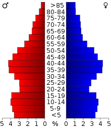 Alterspyramide (2000) des Racine County
Nach der Volkszählung im Jahr 2000 lebten im Racine County 188.831 Menschen in 70.819 Haushalten. 49.856 Familien lebten im County. Die Bevölkerungsdichte betrug 219 Personen pro Quadratkilometer. Ethnisch betrachtet setzte sich die Bevölkerung zusammen aus 83,04 Prozent Weißen, 10,47 Prozent Afroamerikanern, 0,36 Prozent amerikanischen Ureinwohnern, 0,72 Prozent Asiaten, 0,04 Prozent Bewohnern aus dem pazifischen Inselraum und 3,69 Prozent aus anderen ethnischen Gruppen; 1,67 Prozent stammten von zwei oder mehr Ethnien ab. 7,94 Prozent der Bevölkerung waren spanischer oder lateinamerikanischer Abstammung, die verschiedenen der genannten Gruppen angehörten.
Von den 70.819 Haushalten hatten 34,5 Prozent Kinder unter 18 Jahren, die mit ihnen zusammen lebten. 54,0 Prozent davon waren verheiratete, zusammenlebende Paare, 12,3 Prozent waren allein erziehende Mütter. 29,6 Prozent waren keine Familien. 24,5 Prozent waren Singlehaushalte und in 9,2 Prozent lebten Menschen mit 65 Jahren oder älter. Die durchschnittliche Haushaltsgröße lag bei 2,59 und die durchschnittliche Familiengröße bei 3,09 Personen.
27,0 Prozent der Bevölkerung waren unter 18 Jahre alt, 8,3 Prozent zwischen 18 und 24, 29,9 Prozent zwischen 25 und 44, 22,5 Prozent zwischen 45 und 64, und 12,3 Prozent waren 65 Jahre oder älter. Das Durchschnittsalter betrug 36 Jahre. Auf 100 weibliche kamen statistisch 98,0 männliche Personen. [5]
Städte und Gemeinden
- Caledonia
- Elmwood Park
- Mount Pleasant
- North Bay
- Rochester
- Sturtevant
- Union Grove
- Waterford
- Wind Point
- Bohners Lake
- Browns Lake
- Eagle Lake
- Waterford North
- Wind Lake
1 - teilweise im Walworth County
Einzelnachweise
- ↑ Racine County im Geographic Names Information System des United States Geological Survey Abgerufen am 22. Februar 2011
- ↑ U.S. Census Bureau _ Census of Population and Housing Abgerufen am 28. Februar 2011
- ↑ Auszug aus Census.gov Abgerufen am 28. Februar 2011
- ↑ United States Census 2010 Abgerufen am 13. April 2011
- ↑ Racine County, Wisconsin Datenblatt mit den Ergebnissen der Volkszählung im Jahre 2000 bei factfinder.census.gov
Weblinks
-
 Commons: Racine County, Wisconsin – Sammlung von Bildern, Videos und Audiodateien
 - Offizielle Webseite
- Racine County Convention and Visitors Bureau
- www.city-data.com

Liste der Countys in Wisconsin
Adams | Ashland | Barron | Bayfield | Brown | Buffalo | Burnett | Calumet | Chippewa | Clark | Columbia | Crawford | Dane | Dodge | Door | Douglas | Dunn | Eau Claire | Florence | Fond du Lac | Forest | Grant | Green | Green Lake | Iowa | Iron | Jackson | Jefferson | Juneau | Kenosha | Kewaunee | La Crosse | Lafayette | Langlade | Lincoln | Manitowoc | Marathon | Marinette | Marquette | Menominee | Milwaukee | Monroe | Oconto | Oneida | Outagamie | Ozaukee | Pepin | Pierce | Polk | Portage | Price | Racine | Richland | Rock | Rusk | Sauk | Sawyer | Shawano | Sheboygan | St. Croix | Taylor | Trempealeau | Vernon | Vilas | Walworth | Washburn | Washington | Waukesha | Waupaca | Waushara | Winnebago | Wood
Wikimedia Foundation.
Schlagen Sie auch in anderen Wörterbüchern nach:
Racine County — Admin ASC 2 Code Orig. name Racine County Country and Admin Code US.WI.101 US … World countries Adminstrative division ASC I-II
Racine County, Wisconsin — Infobox U.S. County county = Racine County state = Wisconsin map size = 225 founded = seat = Racine | area total sq mi =792 area land sq mi =333 area water sq mi =459 area percentage = 57.94% census yr = 2006 pop = 196096 density km2 =219 web =… … Wikipedia
National Register of Historic Places listings in Racine County, Wisconsin — Buildings, sites, structures, districts, and objects in Racine County listed on the National Register of Historic Places See also: National Register of Historic Places listings in Wisconsin Map of all coordinates from Google … Wikipedia
Dover, Racine County, Wisconsin — Dover, Wisconsin Town Location of Dover, Racine County, Wisconsin … Wikipedia
Caledonia, Racine County, Wisconsin — Infobox Settlement official name = Caledonia other name = nickname = settlement type = Village motto = imagesize = image caption = flag size = image seal size = image blank emblem = blank emblem size = mapsize = 250px map caption = Location of… … Wikipedia
Crestview, Racine County, Wisconsin — Crestview is located in the village of Caledonia in Racine County, Wisconsin, United States. Crestview is 17 miles [27 km] to the southeast of Milwaukee. Information about Crestview: *Population 24,426 *Church St. Mary s by the Lake Parish… … Wikipedia
Racine (Wisconsin) — Racine Spitzname: The Belle City of the Lakes[1] Racine Lage in Wisconsin … Deutsch Wikipedia
Racine Unified School District — Type and location Grades K through 12 Country United States L … Wikipedia
Racine College — East Building showing tunnel heading east toward Lake Michigan … Wikipedia
Racine, Wisconsin — Infobox Settlement official name = Racine, Wisconsin settlement type = City nickname = The Belle City of the Lakes [cite web |url=http://www.wisconsinhistory.org/dictionary/index.asp?action=view term id=4446 term type id=2 term type text=Places… … Wikipedia
Racine County


18+
© Academic, 2000-2026
- Kontaktieren Sie uns: Unterstützung, Werbung
Wörterbücher Export, schritte mit PHP, Joomla, Drupal, WordPress, MODx.