- Waushara County
-
Verwaltung US-Bundesstaat: Wisconsin Verwaltungssitz: Wautoma Adresse des
Verwaltungssitzes:County Courthouse
209 S. St. Marie Street
Wautoma, WI 54982-0488Gründung: 1851 Gebildet aus: Marquette County Vorwahl: 001 920 Demographie Einwohner: 24.496 (2010) Bevölkerungsdichte: 15,1 Einwohner/km² Geographie Fläche gesamt: 1.651 km² Wasserfläche: 29 km² Karte 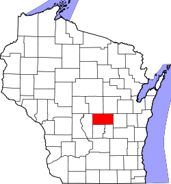
Website: www.co.waushara.wi.us Waushara County[1] ist ein County im Bundesstaat Wisconsin der Vereinigten Staaten von Amerika. Bei der Volkszählung im Jahr 2010 hatte das County 24.496 Einwohner und eine Bevölkerungsdichte von 15,1 Einwohnern pro Quadratkilometer. Der Verwaltungssitz (County Seat) ist Wautoma, das nach einem Indianerhäuptling benannt wurde.
Inhaltsverzeichnis
Geografie
Das County liegt etwas östlich des geografischen Zentrums von Wisconsin und hat eine Fläche von 1651 Quadratkilometern, wovon 29 Quadratkilometer Wasserfläche sind. Es grenzt an folgende Countys:
Portage County Waupaca County Adams County 
Winnebago County Marquette County, Green Lake County Geschichte
Waushara County wurde 1851 aus Teilen des Marquette County gebildet. Benannt wurde es nach dem indianischen Wort für Gute Erde.
Demografische Daten
Historische Einwohnerzahlen Census Einwohner ± in % 1900 15.972 — 1910 18.886 20 % 1920 16.712 -10 % 1930 14.427 -10 % 1940 14.268 -1 % 1950 13.920 -2 % 1960 13.497 -3 % 1970 14.795 10 % 1980 18.526 30 % 1990 19.385 5 % 2000 23.154 20 % 2010 24.496 6 % 1900–1990[2] 2010[3] 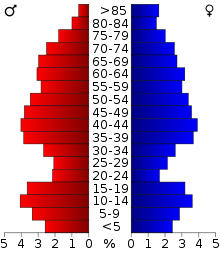 Alterspyramide (2000) des Waushara County
Nach der Volkszählung im Jahr 2000 lebten im Waushara County 23.154 Menschen in 9.336 Haushalten. 6.581 Familien lebten im County. Die Bevölkerungsdichte betrug 14 Personen pro Quadratkilometer. Ethnisch betrachtet setzte sich die Bevölkerung zusammen aus 96,80 Prozent Weißen, 0,27 Prozent Afroamerikanern, 0,31 Prozent amerikanischen Ureinwohnern, 0,35 Prozent Asiaten, 0,03 Prozent Bewohnern aus dem pazifischen Inselraum und 1,36 Prozent aus anderen ethnischen Gruppen; 0,89 Prozent stammten von zwei oder mehr Ethnien ab. 3,66 Prozent der Bevölkerung waren spanischer oder lateinamerikanischer Abstammung, die verschiedenen der genannten Gruppen angehörten.
Von den 9.336 Haushalten hatten 27,6 Prozent Kinder unter 18 Jahren, die mit ihnen zusammen lebten. 60,0 Prozent davon waren verheiratete, zusammenlebende Paare, 6,7 Prozent waren allein erziehende Mütter. 29,5 Prozent waren keine Familien. 24,9 Prozent waren Singlehaushalte.
23,5 Prozent der Bevölkerung waren unter 18 Jahre alt, 6,0 Prozent zwischen 18 und 24, 24,9 Prozent zwischen 25 und 44, 26,3 Prozent zwischen 45 und 64, und 19,2 Prozent waren 65 Jahre oder älter. Das Durchschnittsalter betrug 42 Jahre. Auf 100 weibliche kamen statistisch 101,6 männliche Personen.[4]
Städte und Gemeinden
- Berlin1
- Coloma
- Hancock
- Lohrville
- Plainfield
- Redgranite
- Wautoma
- Wild Rose
1 - teilweise im Green Lake County
Einzelnachweise
- ↑ Waushara County im Geographic Names Information System des United States Geological Survey. Abgerufen am 22. Februar 2011
- ↑ Auszug aus Census.gov Abgerufen am 28. Februar 2011
- ↑ United States Census 2010 Abgerufen am 14. April 2011
- ↑ Waushara County, Wisconsin Datenblatt mit den Ergebnissen der Volkszählung im Jahre 2000 bei factfinder.census.gov
Weblinks
-
 Commons: Waushara County, Wisconsin – Sammlung von Bildern, Videos und Audiodateien
 - Offizielle Webseite
- Waushara County, Wisconsin
- www.city-data.com

Liste der Countys in Wisconsin
Adams | Ashland | Barron | Bayfield | Brown | Buffalo | Burnett | Calumet | Chippewa | Clark | Columbia | Crawford | Dane | Dodge | Door | Douglas | Dunn | Eau Claire | Florence | Fond du Lac | Forest | Grant | Green | Green Lake | Iowa | Iron | Jackson | Jefferson | Juneau | Kenosha | Kewaunee | La Crosse | Lafayette | Langlade | Lincoln | Manitowoc | Marathon | Marinette | Marquette | Menominee | Milwaukee | Monroe | Oconto | Oneida | Outagamie | Ozaukee | Pepin | Pierce | Polk | Portage | Price | Racine | Richland | Rock | Rusk | Sauk | Sawyer | Shawano | Sheboygan | St. Croix | Taylor | Trempealeau | Vernon | Vilas | Walworth | Washburn | Washington | Waukesha | Waupaca | Waushara | Winnebago | Wood
Wikimedia Foundation.
Schlagen Sie auch in anderen Wörterbüchern nach:
Waushara County — Admin ASC 2 Code Orig. name Waushara County Country and Admin Code US.WI.137 US … World countries Adminstrative division ASC I-II
Waushara County, Wisconsin — Infobox U.S. County county = Waushara County state = Wisconsin map size = 300 founded = 1851 seat wl = Wautoma largest city wl = Berlin area total sq mi =637 area land sq mi =626 area water sq mi =11 area percentage = 1.78% census yr = 2000 pop … Wikipedia
Deerfield, Waushara County, Wisconsin — Deerfield, Wisconsin Town Location of Deerfield, Waushara County, Wisconsin … Wikipedia
Marion, Waushara County, Wisconsin — Marion, Wisconsin Town Location of Marion, Waushara County, Wisconsin … Wikipedia
Aurora, Waushara County, Wisconsin — Infobox Settlement official name = Aurora, Wisconsin settlement type = Town nickname = motto = imagesize = image caption = image mapsize = 250px map caption = Location of Aurora, Waushara County, Wisconsin mapsize1 = map caption1 = subdivision… … Wikipedia
Bloomfield, Waushara County, Wisconsin — Infobox Settlement official name = Bloomfield, Wisconsin settlement type = Town nickname = motto = imagesize = image caption = image mapsize = 250px map caption = Location of Bloomfield, Waushara County, Wisconsin mapsize1 = map caption1 =… … Wikipedia
Leon, Waushara County, Wisconsin — Infobox Settlement official name = Leon, Wisconsin settlement type = Town nickname = motto = imagesize = image caption = image mapsize = 250px map caption = Location of Leon, Waushara County, Wisconsin mapsize1 = map caption1 = subdivision type … Wikipedia
Warren, Waushara County, Wisconsin — Infobox Settlement official name = Warren, Wisconsin settlement type = Town nickname = motto = imagesize = image caption = image mapsize = 250x200px map caption = Location of Warren, Waushara County, Wisconsin mapsize1 = map caption1 =… … Wikipedia
Waushara Argus — The Waushara Argus is a local weekly newspaper in Wautoma, Wisconsin. It has been published since 1859.The Argus is published on Wednesdays in broadsheet format. It provides readers with an in depth look into local issues, interesting people,… … Wikipedia
Condado de Waushara — Condado de los Estados Unidos Aurora, Wisconsin … Wikipedia Español
Waushara County


18+
© Academic, 2000-2026
- Kontaktieren Sie uns: Unterstützung, Werbung
Wörterbücher Export, schritte mit PHP, Joomla, Drupal, WordPress, MODx.