- Milwaukee County
-
Verwaltung US-Bundesstaat: Wisconsin Verwaltungssitz: Milwaukee Gründung: 1835 Vorwahl: 001 414 Demographie Einwohner: 947.735 (2010) Bevölkerungsdichte: 1.516,4 Einwohner/km² Geographie Fläche gesamt: 3.081 km² Wasserfläche: 2.456 km² Karte 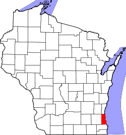
Website: county.milwaukee.gov
Das Milwaukee County[2] ist ein County im Bundesstaat Wisconsin der Vereinigten Staaten von Amerika. Bei der Volkszählung im Jahr 2010 hatte das County 947.735 Einwohner und eine Bevölkerungsdichte von 1516,4 Einwohnern pro Quadratkilometer. Der Verwaltungssitz (County Seat) ist Milwaukee.Das Milwaukee County liegt im Zentrum der Metropolregion Milwaukee.
Inhaltsverzeichnis
Geografie
Das County liegt am Westufer des Michigansees und hat eine Fläche von 3.081 Quadratkilometern, wovon 2.456 Quadratkilometer Wasserfläche sind. An das Milwaukee County grenzen folgende Countys:
Washington County Ozaukee County Waukesha County 
Racine County Geschichte
Das Milwaukee County wurde 1835 auf ursprünglich von Indianern besiedelten Gebiet gegründet. Der Name Milwaukee stammt aus stammt vom Algonkin-Wort Mahnawaukee-Seepe ab, was etwa Versammlungsplatz am Fluss bedeutet.
Demografische Daten
Historische Einwohnerzahlen Census Einwohner ± in % 1850 31.077 — 1860 62.518 100 % 1870 89.930 40 % 1880 138.537 50 % 1890 236.101 70 % 1900 330.017 40 % 1910 433.187 30 % 1920 539.449 20 % 1930 725.263 30 % 1940 766.885 6 % 1950 871.047 10 % 1960 1.036.041 20 % 1970 1.054.063 2 % 1980 964.988 -8 % 1990 959.275 -0,6 % 2000 940.164 -2 % 2010 947.735 0,8 % Vor 1900[3]  Alterspyramide des Milwaukee County (2000)
Nach der Volkszählung im Jahr 2000 lebten im Milwaukee County 940.164 Menschen in 377.729 Haushalten und 225.126 Familien. Die Bevölkerungsdichte betrug 1.503 Personen pro Quadratkilometer. Ethnisch betrachtet setzte sich die Bevölkerung zusammen aus 65,62 Prozent Weißen, 24,59 Prozent Schwarzen oder Afroamerikanern, 0,72 Prozent amerikanischen Ureinwohnern, 2,57 Prozent Asiaten, 0,04 Prozent Bewohnern aus dem pazifischen Inselraum und 4,25 Prozent aus anderen ethnischen Gruppen. Etwa 2,21 Prozent stammten von zwei oder mehr ethnischen Gruppen ab und 8,77 Prozent der Bevölkerung waren spanischer oder lateinamerikanischer Abstammung, die verschiedenen der genannten Gruppen angehörten.
Von den 377.729 Haushalten hatten 29,50 Prozent Kinder unter 18 Jahren, die mit ihnen zusammen lebten. 39,00 Prozent davon waren verheiratete und zusammenlebende Paare, 16,30 Prozent waren allein erziehende Mütter. 40,40 Prozent waren keine Familien. 33,00 Prozent waren Singlehaushalte und in 10,70 Prozent lebten Menschen mit 65 Jahren oder älter. Die durchschnittliche Haushaltsgröße lag bei 2,43 und die durchschnittliche Familiengröße bei 3,13 Personen.
26,40 Prozent der Bevölkerung waren unter 18 Jahre alt, 10,50 Prozent zwischen 18 und 24, 30,30 Prozent zwischen 25 und 44, 20,00 Prozent zwischen 45 und 64, und 12,90 Prozent waren 65 Jahre oder älter. Das Durchschnittsalter betrug 34 Jahre. Auf 100 weibliche kamen statistisch 92,00 männliche Personen.[6]
Städte und Gemeinden
- Cudahy
- Franklin
- Glendale
- Greenfield
- Bayside1
- Brown Deer
- Fox Point
- Greendale
- Hales Corners
- River Hills
- Shorewood
- West Milwaukee
- Whitefish Bay
1 - teilweise im Ozaukee County
2 - teilweise im Washington und im Waukesha CountyEinzelnachweise
- ↑ Auszug aus dem National Register of Historic Places - Nr. 82000687 Abgerufen am 10. April 2011
- ↑ Milwaukee County im Geographic Names Information System des United States Geological Survey Abgerufen am 22. Februar 2011
- ↑ U.S. Census Bureau _ Census of Population and Housing Abgerufen am 28. Februar 2011
- ↑ Auszug aus Census.gov. Abgerufen am 28. Februar 2011
- ↑ United States Census 2010 Abgerufen am 10. April 2011
- ↑ Milwaukee County, Wisconsin Datenblatt mit den Ergebnissen der Volkszählung im Jahre 2000 bei factfinder.census.gov
Weblinks
-
 Commons: Milwaukee County, Wisconsin – Sammlung von Bildern, Videos und Audiodateien
 - Offizielle Webseite
- www.city-data.com

Liste der Countys in Wisconsin
Adams | Ashland | Barron | Bayfield | Brown | Buffalo | Burnett | Calumet | Chippewa | Clark | Columbia | Crawford | Dane | Dodge | Door | Douglas | Dunn | Eau Claire | Florence | Fond du Lac | Forest | Grant | Green | Green Lake | Iowa | Iron | Jackson | Jefferson | Juneau | Kenosha | Kewaunee | La Crosse | Lafayette | Langlade | Lincoln | Manitowoc | Marathon | Marinette | Marquette | Menominee | Milwaukee | Monroe | Oconto | Oneida | Outagamie | Ozaukee | Pepin | Pierce | Polk | Portage | Price | Racine | Richland | Rock | Rusk | Sauk | Sawyer | Shawano | Sheboygan | St. Croix | Taylor | Trempealeau | Vernon | Vilas | Walworth | Washburn | Washington | Waukesha | Waupaca | Waushara | Winnebago | Wood
Wikimedia Foundation.
Schlagen Sie auch in anderen Wörterbüchern nach:
Milwaukee County — Admin ASC 2 Code Orig. name Milwaukee County Country and Admin Code US.WI.079 US … World countries Adminstrative division ASC I-II
Milwaukee County Stadium — County Stadium Location 201 South 46th Street Milwaukee, Wisconsin 53208 … Wikipedia
Milwaukee County, Wisconsin — Seal … Wikipedia
Milwaukee County Courthouse — U.S. National Register of Historic Places … Wikipedia
Milwaukee County Zoo — Date opened January 16, 1892 (Washington Park Site) May 13, 1961 (Current Site)[1] Location 10001 W. Bluemound Rd … Wikipedia
Milwaukee County Stadium — Généralités Surnom County Stadium Adresse 201 South 46th Street Milwaukee, WI 53201 … Wikipédia en Français
Milwaukee County Federated Library System — MCFLS offices, located in the Milwaukee Central Library Country United States of America Type … Wikipedia
Milwaukee County Zoological Gardens — Infobox zoo zoo name=Milwaukee County Zoo image width=225px image caption=Entrance sign for the zoo area=200 acres (0.8 km²) date opened=January 16, 1892 (Washington Park site) [http://www.milwaukeezoo.org/timeline/index.html Milwaukee County Zoo … Wikipedia
Milwaukee County Transit System — MCTS redirects here. For the Microsoft certification MCTS, see Microsoft Certified Professional. For the fatty ester see Medium chain triglycerides. . For the computer operating system see Multiple Console Time Sharing System. Milwaukee County… … Wikipedia
Milwaukee County Board of Supervisors — The Milwaukee County Board of Supervisors is the legislative branch of the government of Milwaukee County, Wisconsin, United States. Supervisors are elected to the board in nonpartisan elections. There are 19 supervisors.[1] The county board has… … Wikipedia
Milwaukee County


18+
© Academic, 2000-2025
- Kontaktieren Sie uns: Unterstützung, Werbung
Wörterbücher Export, schritte mit PHP, Joomla, Drupal, WordPress, MODx.