- Manitowoc County
-
Verwaltung US-Bundesstaat: Wisconsin Verwaltungssitz: Manitowoc Adresse des
Verwaltungssitzes:County Administration Building
1110 South 9th Street
Manitowoc, WI 54220-5316Gründung: 1836 Gebildet aus: Original-County Vorwahl: 001 920 Demographie Einwohner: 81.442 (2010) Bevölkerungsdichte: 53,2 Einwohner/km² Geographie Fläche gesamt: 3.869 km² Wasserfläche: 2.338 km² Karte 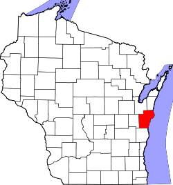
Website: www.co.manitowoc.wi.us/ Manitowoc County[2] ist ein County im Bundesstaat Wisconsin der Vereinigten Staaten von Amerika. Bei der Volkszählung im Jahr 2010 hatte das County 81.442 Einwohner und eine Bevölkerungsdichte von 53,2 Einwohnern pro Quadratkilometer. Der Verwaltungssitz (County Seat) ist Manitowoc.
Inhaltsverzeichnis
Geografie
Das County liegt im Osten von Wisconsin, grenzt an den Michigansee und hat eine Fläche von 3869 Quadratkilometern, wovon 2338 Quadratkilometer Wasserfläche sind. Es grenzt an folgende Countys:
Brown County Kewaunee County Calumet County 
Sheboygan County Geschichte
Manitowoc County wurde 1836 als Original-County aus Teilen des Wisconsin-Territoriums gebildet. Benannt wurde es, ebenso wie die Bezirkshauptstadt, nach einem indianischen Ausdruck, der frei übersetzt so viel wie geheimnisvolles Land bedeutet.
Demografische Daten
Historische Einwohnerzahlen Census Einwohner ± in % 1900 42.261 — 1910 44.978 6 % 1920 51.644 10 % 1930 58.674 10 % 1940 61.617 5 % 1950 67.159 9 % 1960 75.215 10 % 1970 82.294 9 % 1980 82.918 0,8 % 1990 80.421 -3 % 2000 82.887 3 % 2010 81.442 -2 % 1900–1990[3] 2010[4]  Alterspyramide (2000) des Manitowoc County.
Nach der Volkszählung im Jahr 2000 lebten im Manitowoc County 82.887 Menschen in 32.721 Haushalten. 22.348 Familien lebten im County. Die Bevölkerungsdichte betrug 54 Personen pro Quadratkilometer. Ethnisch betrachtet setzte sich die Bevölkerung zusammen aus 95,90 Prozent Weißen, 0,30 Prozent Afroamerikanern, 0,43 Prozent Indianern, 1,98 Prozent Asiatischen Amerikanern, 0,04 Prozent Pazifischen Insulanern und 0,60 Prozent aus anderen ethnischen Gruppen; 0,76 Prozent stammten von zwei oder mehr Ethnien ab. 1,62 Prozent der Bevölkerung waren Hispanics oder Latinos, die verschiedenen der genannten Gruppen angehörten.
Von den 32.721 Haushalten hatten 31,5 Prozent Kinder unter 18 Jahren, die mit ihnen zusammen lebten. 57,1 Prozent davon waren verheiratete, zusammenlebende Paare, 7,5 Prozent waren allein erziehende Mütter. 31,7 Prozent waren keine Familien. 26,8 Prozent waren Singlehaushalte und in 12,1 Prozent lebten Menschen mit 65 Jahren oder älter. Die durchschnittliche Haushaltsgröße lag bei 2,49 und die durchschnittliche Familiengröße bei 3,04 Personen.
25,5 Prozent der Bevölkerung waren unter 18 Jahre alt, 7,6 Prozent zwischen 18 und 24, 28,2 Prozent zwischen 25 und 44, 23,0 Prozent zwischen 45 und 64, und 15,7 Prozent waren 65 Jahre oder älter. Das Durchschnittsalter betrug 38 Jahre. Auf 100 weibliche kamen statistisch 98,2 männliche Personen.[5]
Städte und Gemeinden
- Cleveland
- Francis Creek
- Kiel1
- Kellnersville
- Manitowoc
- Maribel
- Mishicot
- Reedsville
- St. Nazianz
- Two Rivers
- Valders
- Whitelaw
1 - teilweise im Calumet County
Einzelnachweise
- ↑ Auszug aus dem National Register of Historic Places - Nr. 81000047 Abgerufen am 10. April 2011
- ↑ Manitowoc County im Geographic Names Information System des United States Geological Survey Abgerufen am 22. Februar 2011
- ↑ Auszug aus Census.gov Abgerufen am 28. Februar 2011
- ↑ United States Census 2010 Abgerufen am 10. April 2011
- ↑ Manitowoc County, Wisconsin, Datenblatt mit den Ergebnissen der Volkszählung im Jahre 2000 bei factfinder.census.gov
Weblinks
-
 Commons: Manitowoc County, Wisconsin – Sammlung von Bildern, Videos und Audiodateien
 - Offizielle Webseite
- www.city-data.com

Liste der Countys in Wisconsin
Adams | Ashland | Barron | Bayfield | Brown | Buffalo | Burnett | Calumet | Chippewa | Clark | Columbia | Crawford | Dane | Dodge | Door | Douglas | Dunn | Eau Claire | Florence | Fond du Lac | Forest | Grant | Green | Green Lake | Iowa | Iron | Jackson | Jefferson | Juneau | Kenosha | Kewaunee | La Crosse | Lafayette | Langlade | Lincoln | Manitowoc | Marathon | Marinette | Marquette | Menominee | Milwaukee | Monroe | Oconto | Oneida | Outagamie | Ozaukee | Pepin | Pierce | Polk | Portage | Price | Racine | Richland | Rock | Rusk | Sauk | Sawyer | Shawano | Sheboygan | St. Croix | Taylor | Trempealeau | Vernon | Vilas | Walworth | Washburn | Washington | Waukesha | Waupaca | Waushara | Winnebago | Wood
Wikimedia Foundation.
Schlagen Sie auch in anderen Wörterbüchern nach:
Manitowoc County — Admin ASC 2 Code Orig. name Manitowoc County Country and Admin Code US.WI.071 US … World countries Adminstrative division ASC I-II
Manitowoc County, Wisconsin — Seal … Wikipedia
Manitowoc County Airport — IATA: MTW – ICAO: KMTW – FAA LID: MTW Summary Airport type Public Owner/Operator Manitowoc Count … Wikipedia
National Register of Historic Places listings in Manitowoc County, Wisconsin — Buildings, sites, districts, and objects in Manitowoc County listed on the National Register of Historic Places See also: National Register of Historic Places listings in Wisconsin This National Park Service list is complete through NPS recent… … Wikipedia
Newton (community), Manitowoc County, Wisconsin — Newton, Wisconsin Unincorporated community Looking south in Newton … Wikipedia
Cleveland, Manitowoc County, Wisconsin — Cleveland Village … Wikipedia
Maple Grove, Manitowoc County, Wisconsin — Maple Grove, Wisconsin Town Location of Maple Grove, Wisconsin … Wikipedia
Newton, Manitowoc County, Wisconsin — Newton, Wisconsin Town Location of Newton, Wisconsin Coordi … Wikipedia
Clover, Manitowoc County, Wisconsin — Clover, Wisconsin Unincorporated community … Wikipedia
Eaton, Manitowoc County, Wisconsin — Infobox Settlement official name = Eaton, Wisconsin settlement type = Town nickname = motto = imagesize = image caption = image mapsize = 250px map caption = Location of Eaton, Wisconsin mapsize1 = map caption1 = subdivision type = Country… … Wikipedia
Manitowoc County


18+
© Academic, 2000-2024
- Kontaktieren Sie uns: Unterstützung, Werbung
Wörterbücher Export, schritte mit PHP, Joomla, Drupal, WordPress, MODx.