- Rock County (Wisconsin)
-
Verwaltung US-Bundesstaat: Wisconsin Verwaltungssitz: Janesville Adresse des
Verwaltungssitzes:County Courthouse
51 S Main Street
Janesville, WI 53545-3951Gründung: 1836 Gebildet aus: Original-County Vorwahl: 001 608 Demographie Einwohner: 160.331 (2010) Bevölkerungsdichte: 85,9 Einwohner/km² Geographie Fläche gesamt: 1.881 km² Wasserfläche: 15 km² Karte 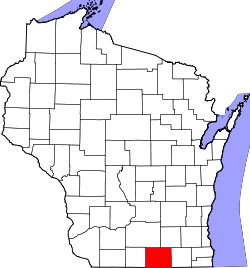
Website: www.co.rock.wi.us Rock County[1] ist ein County im Bundesstaat Wisconsin der Vereinigten Staaten von Amerika. Bei der Volkszählung im Jahr 2010 hatte das County 160.331 Einwohner und eine Bevölkerungsdichte von 85,9 Einwohnern pro Quadratkilometer. Der Verwaltungssitz (County Seat) ist Janesville, das nach Henry F. Janes benannt wurde, der als erster hier einen regulären Fährdienst bereitstellte.
Inhaltsverzeichnis
Geografie
Das County liegt im Süden von Wisconsin und wird vom Rock River durchflossen. Das Rock County grenzt an Illinois und hat eine Fläche von 1881 Quadratkilometern, wovon 15 Quadratkilometer Wasserfläche sind. Es grenzt an folgende Countys:
Dane County Jefferson County Green County 
Walworth County Winnebago County
(Illinois)Boone County
(Illinois)Geschichte
Rock County wurde 1836 als Original-County aus Teilen des Wisconsin-Territoriums gebildet. Benannt wurde es nach dem Rock River.
Demografische Daten
Historische Einwohnerzahlen Census Einwohner ± in % 1900 51.203 — 1910 55.538 8 % 1920 66.150 20 % 1930 74.206 10 % 1940 80.173 8 % 1950 92.778 20 % 1960 113.913 20 % 1970 131.970 20 % 1980 139.420 6 % 1990 139.510 0,06 % 2000 152.307 9 % 2010 160.331 5 % 1900–1990[2] 2010[3]  Alterspyramide (2000) des Rock County
Nach der Volkszählung im Jahr 2000 lebten im Rock County 152.307 Menschen in 58.617 Haushalten. 40.387 Familien lebten im County. Die Bevölkerungsdichte betrug 82 Personen pro Quadratkilometer. Ethnisch betrachtet setzte sich die Bevölkerung zusammen aus 91,01 Prozent Weißen, 4,63 Prozent Afroamerikanern, 0,28 Prozent amerikanischen Ureinwohnern, 0,78 Prozent Asiaten, 0,04 Prozent Bewohnern aus dem pazifischen Inselraum und 1,77 Prozent aus anderen ethnischen Gruppen; 1,50 Prozent stammten von zwei oder mehr Ethnien ab. 3,91 Prozent der Bevölkerung waren spanischer oder lateinamerikanischer Abstammung, die verschiedenen der genannten Gruppen angehörten.
Von den 58.617 Haushalten hatten 33,6 Prozent Kinder unter 18 Jahren, die mit ihnen zusammen lebten. 53,5 Prozent davon waren verheiratete, zusammenlebende Paare, 10,9 Prozent waren allein erziehende Mütter. 31,1 Prozent waren keine Familien. 25,1 Prozent waren Singlehaushalte und in 9,7 Prozent lebten Menschen mit 65 Jahren oder älter. Die durchschnittliche Haushaltsgröße lag bei 2,54 und die durchschnittliche Familiengröße bei 3,03 Personen.
26,5 Prozent der Bevölkerung waren unter 18 Jahre alt, 8,6 Prozent zwischen 18 und 24, 29,8 Prozent zwischen 25 und 44, 22,3 Prozent zwischen 45 und 64, und 12,7 Prozent waren 65 Jahre oder älter. Das Durchschnittsalter betrug 36 Jahre. Auf 100 weibliche kamen statistisch 97,0 männliche Personen.[4]
Städte und Gemeinden
- Beloit
- Brodhead1
- Clinton
- Edgerton
- Evansville
- Footville
- Janesville
- Milton
- Orfordville
1 - teilweise im Green County
Einzelnachweise
- ↑ Rock County im Geographic Names Information System des United States Geological Survey Abgerufen am 22. Februar 2011
- ↑ Auszug aus Census.gov Abgerufen am 28. Februar 2011
- ↑ United States Census 2010 Abgerufen am 13. April 2011
- ↑ Rock County, Wisconsin Datenblatt mit den Ergebnissen der Volkszählung im Jahre 2000 bei factfinder.census.gov
Weblinks
-
 Commons: Rock County, Wisconsin – Sammlung von Bildern, Videos und Audiodateien
 - Offizielle Webseite
- www.city-data.com

Liste der Countys in Wisconsin
Adams | Ashland | Barron | Bayfield | Brown | Buffalo | Burnett | Calumet | Chippewa | Clark | Columbia | Crawford | Dane | Dodge | Door | Douglas | Dunn | Eau Claire | Florence | Fond du Lac | Forest | Grant | Green | Green Lake | Iowa | Iron | Jackson | Jefferson | Juneau | Kenosha | Kewaunee | La Crosse | Lafayette | Langlade | Lincoln | Manitowoc | Marathon | Marinette | Marquette | Menominee | Milwaukee | Monroe | Oconto | Oneida | Outagamie | Ozaukee | Pepin | Pierce | Polk | Portage | Price | Racine | Richland | Rock | Rusk | Sauk | Sawyer | Shawano | Sheboygan | St. Croix | Taylor | Trempealeau | Vernon | Vilas | Walworth | Washburn | Washington | Waukesha | Waupaca | Waushara | Winnebago | Wood
Wikimedia Foundation.
Schlagen Sie auch in anderen Wörterbüchern nach:
Rock, Rock County, Wisconsin — Infobox Settlement official name = Rock, Wisconsin settlement type = Town nickname = motto = imagesize = image caption = image mapsize = 250px map caption = Location of Rock, Rock County, Wisconsin mapsize1 = map caption1 = subdivision type =… … Wikipedia
Rock County, Wisconsin — Infobox U.S. County county = Rock County state = Wisconsin map size = 225 founded = seat = Janesville | area total sq mi =726 area land sq mi =720 area water sq mi =6 area percentage = 0.79% census yr = 2000 pop = 152307 density km2 =82 web = www … Wikipedia
Milton, Rock County, Wisconsin — Milton, Wisconsin Town Location of Milton, Rock County, Wisconsin … Wikipedia
National Register of Historic Places listings in Rock County, Wisconsin — Buildings, sites, structures, districts, and objects in Rock County listed on the National Register of Historic Places See also: National Register of Historic Places listings in Wisconsin Map of all coordinates from Google … Wikipedia
Clinton (town), Rock County, Wisconsin — For the village of Clinton, see Clinton (village), Rock County, Wisconsin. Clinton, Wisconsin Town Location o … Wikipedia
Tiffany, Rock County, Wisconsin — Tiffany, Wisconsin Unincorporated community … Wikipedia
Clinton (village), Rock County, Wisconsin — Clinton Village … Wikipedia
Crestview, Rock County, Wisconsin — is an unincorporated community in the town of Turtle in Rock County, Wisconsin, United States. v · … Wikipedia
Clinton, Rock County, Wisconsin — There are two other towns named Clinton in Wisconsin. Infobox Settlement official name = Clinton, Wisconsin settlement type = Town nickname = motto = imagesize = image caption = image mapsize = 250px map caption = Location of Clinton, Rock County … Wikipedia
Center, Rock County, Wisconsin — Infobox Settlement official name = Center, Wisconsin settlement type = Town nickname = motto = imagesize = image caption = image mapsize = 250px map caption = Location of Center, Rock County, Wisconsin mapsize1 = map caption1 = subdivision type … Wikipedia
Rock County (Wisconsin)


18+
© Academic, 2000-2026
- Kontaktieren Sie uns: Unterstützung, Werbung
Wörterbücher Export, schritte mit PHP, Joomla, Drupal, WordPress, MODx.