- Waukesha County
-
Verwaltung US-Bundesstaat: Wisconsin Verwaltungssitz: Waukesha Adresse des
Verwaltungssitzes:County Courthouse
515 W. Moreland Blvd
Waukesha, WI 53188-2428Gründung: 1846 Gebildet aus: Milwaukee County Vorwahl: 001 262 Demographie Einwohner: 389.891 (2010) Bevölkerungsdichte: 271,1 Einwohner/km² Geographie Fläche gesamt: 1.503 km² Wasserfläche: 65 km² Karte 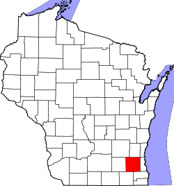
Website: www.waukeshacounty.gov Waukesha County[1] ist ein County im Bundesstaat Wisconsin der Vereinigten Staaten von Amerika. Bei der Volkszählung im Jahr 2010 hatte das County 389.891 Einwohner und eine Bevölkerungsdichte von 271,2 Einwohnern pro Quadratkilometer. Der Verwaltungssitz (County Seat) ist Waukesha.
Das Waukesha County ist Bestandteil der Metropolregion Milwaukee.
Inhaltsverzeichnis
Geografie
Das County liegt im Südosten von Wisconsin, ist im Osten etwa 30 km vom Michigansee entfernt und hat eine Fläche von 1503 Quadratkilometern, wovon 65 Quadratkilometer Wasserfläche sind. Es grenzt an folgende Countys:
Dodge County Washington County Ozaukee County Jefferson County 
Milwaukee County Walworth County Racine County Geschichte
Waukesha County wurde 1846 aus Teilen des Milwaukee County gebildet. Benannt wurde es, ebenso wie die Bezirkshauptstadt, nach dem indianischen Ausdruck für Kleiner Fuchs.
Historische Objekte
In Menomonee Falls befindet sich am Roosevelt Drive, die historische Third Street Bridge (auch bekannt als Roosevelt Drive Bridge). Die 1899 errichtete Brücke wurde am 21. September 1988 vom National Register of Historic Places als historisches Denkmal mit der Nummer 88001647 aufgenommen.[2][3]
Demografische Daten
Historische Einwohnerzahlen Census Einwohner ± in % 1850 19.258 — 1860 26.831 40 % 1870 28.274 5 % 1880 28.957 2 % 1890 44.270 50 % 1900 35.229 -20 % 1910 37.100 5 % 1920 42.612 10 % 1930 52.358 20 % 1940 62.744 20 % 1950 85.901 40 % 1960 158.249 80 % 1970 231.365 50 % 1980 280.326 20 % 1990 304.715 9 % 2000 360.767 20 % 2010 389.891 8 % Vor 1900[4] 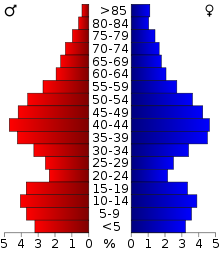 Alterspyramide (2000) des Waukesha County
Nach der Volkszählung im Jahr 2000 lebten im Waukesha County 360.767 Menschen in 135.229 Haushalten. 100.475 Familien lebten im County. Die Bevölkerungsdichte betrug 251 Personen pro Quadratkilometer. Ethnisch betrachtet setzte sich die Bevölkerung zusammen aus 95,77 Prozent Weißen, 0,73 Prozent Afroamerikanern, 0,22 Prozent amerikanischen Ureinwohnern, 1,49 Prozent Asiaten, 0,02 Prozent Bewohnern aus dem pazifischen Inselraum und 0,87 Prozent aus anderen ethnischen Gruppen; 0,90 Prozent stammten von zwei oder mehr Ethnien ab. 2,63 Prozent der Bevölkerung waren spanischer oder lateinamerikanischer Abstammung, die verschiedenen der genannten Gruppen angehörten.
Von den 135.229 Haushalten hatten 35,4 Prozent Kinder unter 18 Jahren, die mit ihnen zusammen lebten. 64,8 Prozent davon waren verheiratete, zusammenlebende Paare, 6,8 Prozent waren allein erziehende Mütter. 25,7 Prozent waren keine Familien. 20,9 Prozent waren Singlehaushalte und in 8,1 Prozent lebten Menschen mit 65 Jahren oder älter. Die durchschnittliche Haushaltsgröße lag bei 2,63 und die durchschnittliche Familiengröße bei 3,08 Personen.
26,3 Prozent der Bevölkerung waren unter 18 Jahre alt, 6,8 Prozent zwischen 18 und 24, 29,8 Prozent zwischen 25 und 44, 25,1 Prozent zwischen 45 und 64, und 12,0 Prozent waren 65 Jahre oder älter. Das Durchschnittsalter betrug 38 Jahre. Auf 100 weibliche kamen statistisch 96,8 männliche Personen.[7]
Städte und Gemeinden
- Brookfield
- Delafield
- Milwaukee1
- Muskego
- New Berlin
- Oconomowoc
- Pewaukee
- Waukesha
- Big Bend
- Butler
- Chenequa
- Dousman
- Eagle
- Elm Grove
- Hartland
- Lac La Belle
- Lannon
- Menomonee Falls
- Merton
- Mukwonago
- Nashotah
- North Prairie
- Oconomowoc Lake
- Okauchee Lake
- Pewaukee
- Sussex
- Wales
1 - überwiegend im Milwaukee County, teilweise im Washington County
Einzelnachweise
- ↑ Waukesha County im Geographic Names Information System des United States Geological Survey Abgerufen am 22. Februar 2011
- ↑ NRIS
- ↑ Roosevelt Drive Bridge, Spanning Menomonee River at Roosevelt Road, Menomonee Falls, Waukesha, WI
- ↑ U.S. Census Bureau _ Census of Population and Housing Abgerufen am 28. Februar 2011
- ↑ Auszug aus Census.gov. Abgerufen am 28. Februar 2011
- ↑ United States Census 2010 Abgerufen am 14. April 2011
- ↑ Waukesha County, Wisconsin Datenblatt mit den Ergebnissen der Volkszählung im Jahre 2000 bei factfinder.census.gov
Weblinks
-
 Commons: Waukesha County, Wisconsin – Sammlung von Bildern, Videos und Audiodateien
 - Offizielle Webseite
- www.city-data.com

Liste der Countys in Wisconsin
Adams | Ashland | Barron | Bayfield | Brown | Buffalo | Burnett | Calumet | Chippewa | Clark | Columbia | Crawford | Dane | Dodge | Door | Douglas | Dunn | Eau Claire | Florence | Fond du Lac | Forest | Grant | Green | Green Lake | Iowa | Iron | Jackson | Jefferson | Juneau | Kenosha | Kewaunee | La Crosse | Lafayette | Langlade | Lincoln | Manitowoc | Marathon | Marinette | Marquette | Menominee | Milwaukee | Monroe | Oconto | Oneida | Outagamie | Ozaukee | Pepin | Pierce | Polk | Portage | Price | Racine | Richland | Rock | Rusk | Sauk | Sawyer | Shawano | Sheboygan | St. Croix | Taylor | Trempealeau | Vernon | Vilas | Walworth | Washburn | Washington | Waukesha | Waupaca | Waushara | Winnebago | Wood
Wikimedia Foundation.
Schlagen Sie auch in anderen Wörterbüchern nach:
Waukesha County — Admin ASC 2 Code Orig. name Waukesha County Country and Admin Code US.WI.133 US … World countries Adminstrative division ASC I-II
Waukesha County, Wisconsin — Infobox U.S. County county = Waukesha County state = Wisconsin map size = 200 founded = 1846 seat = Waukesha | area total sq mi =580 area land sq mi =556 area water sq mi =25 area percentage = 4.29% census yr = 2000 pop = 360767 density km2 =251… … Wikipedia
Waukesha County Airport — Infobox Airport name = Waukesha County Airport nativename = Crites Field IATA = UES ICAO = KUES FAA = UES type = Public owner oper = Waukesha County location = Waukesha, Wisconsin elevation f = 911 elevation m = 278 website =… … Wikipedia
Waukesha County Technical College — Infobox University name = Waukesha County Technical College native name = latin name = motto = established = type = State Technical College endowment = staff = faculty = president = Barbara Prindiville principal = rector = chancellor = vice… … Wikipedia
National Register of Historic Places listings in Waukesha County, Wisconsin — Buildings, sites, structures, districts, and objects in Waukesha County listed on the National Register of Historic Places See also: National Register of Historic Places listings in Wisconsin Map of all coordinates from Google … Wikipedia
List of Registered Historic Places in Waukesha County, Wisconsin — Buildings, sites, structures, districts, and objects in Waukesha County listed on the National Register of Historic Places: See also: National Register of Historic Places listings in Wisconsin:: Wisconsin NRHP date for lists This document is… … Wikipedia
Oak Grove Cemetery (Waukesha County, Wisconsin) — Der Oak Grove Cemetery (auch bekannt als Presbyterian Cemetery and Potter’s Field[1]) ist ein Friedhof im Waukesha County im US Bundesstaat Wisconsin. Er liegt am Wisconsin Highway 67 und grenzt direkt an die Eagle Oak Opening State Natural… … Deutsch Wikipedia
Lisbon, Waukesha County, Wisconsin — Infobox Settlement official name = Lisbon, Wisconsin settlement type = Town nickname = motto = imagesize = image caption = image mapsize = 250x200px map caption = Location of Lisbon, Waukesha County, Wisconsin mapsize1 = map caption1 =… … Wikipedia
Summit, Waukesha County, Wisconsin — Infobox Settlement official name = Summit, Wisconsin settlement type = Town nickname = motto = imagesize = image caption = image mapsize = 250x200px map caption = Location of Summit, Waukesha County, Wisconsin mapsize1 = map caption1 =… … Wikipedia
Big Bend, Waukesha County, Wisconsin — Big Bend is a village in Waukesha County, Wisconsin, United States. The population was 1,278 at the 2000 census. For other places with the same name see Big Bend.GeographyBig Bend is located at coor dms|42|53|16|N|88|12|41|W|city (42.887862,… … Wikipedia
Waukesha County


18+
© Academic, 2000-2025
- Kontaktieren Sie uns: Unterstützung, Werbung
Wörterbücher Export, schritte mit PHP, Joomla, Drupal, WordPress, MODx.