- Vilas County
-
Verwaltung US-Bundesstaat: Wisconsin Verwaltungssitz: Eagle River Adresse des
Verwaltungssitzes:County Courthouse
330 Court Street
Eagle River, WI 54521-8362Gründung: 1893 Gebildet aus: Oneida County Vorwahl: 001 715 Demographie Einwohner: 21.430 (2010) Bevölkerungsdichte: 9,5 Einwohner/km² Geographie Fläche gesamt: 2.636 km² Wasserfläche: 373 km² Karte 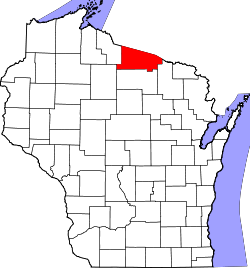
Website: co.vilas.wi.us Das Vilas County[1] ist ein County im Bundesstaat Wisconsin der Vereinigten Staaten von Amerika. Bei der Volkszählung im Jahr 2010 hatte das County 21.430 Einwohner und eine Bevölkerungsdichte von 9,5 Einwohnern pro Quadratkilometer. Der Verwaltungssitz (County Seat) ist Eagle River.
Inhaltsverzeichnis
Geografie
Das County liegt im Norden von Wisconsin, grenzt an Michigan und hat eine Fläche von 2636 Quadratkilometern, wovon 373 Quadratkilometer Wasserfläche sind. Es grenzt an folgende Countys:
Gogebic County
(Michigan)Iron County
(Michigan)Iron County 
Price County Oneida County Forest County Geschichte
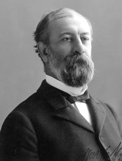
 William Vilas
Das Vilas County wurde 1893 aus Teilen des Oneida County gebildet. Benannt wurde es nach William Vilas (1840-1908), einem früheren Senator, Postminister und Innenminister der USA.
Demografische Daten
Historische Einwohnerzahlen Census Einwohner ± in % 1900 4929 — 1910 6019 20 % 1920 5649 -6 % 1930 7294 30 % 1940 8894 20 % 1950 9363 5 % 1960 9332 -0,3 % 1970 10.958 20 % 1980 16.535 50 % 1990 17.707 7 % 2000 21.033 20 % 2010 21.430 2 % 1900–1990[2] 2010[3] 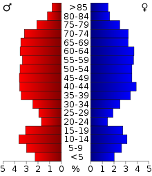 Alterspyramide (2000) des Vilas County
Nach der Volkszählung im Jahr 2000 lebten im Vilas County 21.033 Menschen in 9.066 Haushalten. 6.300 Familien lebten im County. Die Bevölkerungsdichte betrug 9 Personen pro Quadratkilometer. Ethnisch betrachtet setzte sich die Bevölkerung zusammen aus 89,69 Prozent Weißen, 0,20 Prozent Afroamerikanern, 9,08 Prozent amerikanischen Ureinwohnern, 0,18 Prozent Asiaten, 0,01 Prozent Bewohnern aus dem pazifischen Inselraum und 0,19 Prozent aus anderen ethnischen Gruppen; 0,65 Prozent stammten von zwei oder mehr Ethnien ab. 0,86 Prozent der Bevölkerung waren spanischer oder lateinamerikanischer Abstammung, die verschiedenen der genannten Gruppen angehörten.
Von den 9.066 Haushalten hatten 23,4 Prozent Kinder unter 18 Jahren, die mit ihnen zusammen lebten. 58,4 Prozent davon waren verheiratete, zusammenlebende Paare, 7,5 Prozent waren allein erziehende Mütter. 30,5 Prozent waren keine Familien. 26,0 Prozent waren Singlehaushalte und in 12,6 Prozent lebten Menschen mit 65 Jahren oder älter. Die durchschnittliche Haushaltsgröße lag bei 2,29 und die durchschnittliche Familiengröße bei 2,73 Personen.
20,7 Prozent der Bevölkerung waren unter 18 Jahre alt, 5,0 Prozent zwischen 18 und 24, 23,1 Prozent zwischen 25 und 44, 28,5 Prozent zwischen 45 und 64, und 22,8 Prozent waren 65 Jahre oder älter. Das Durchschnittsalter betrug 46 Jahre. Auf 100 weibliche kamen statistisch 99,1 männliche Personen.[4]
Städte und Gemeinden
- Eagle River
- Lac de Flambeau
Einzelnachweise
- ↑ Vilas County im Geographic Names Information System des United States Geological Survey Abgerufen am 22. Februar 2011
- ↑ Auszug aus Census.gov Abgerufen am 28. Februar 2011
- ↑ United States Census 2010 Abgerufen am 13. April 2011
- ↑ Vilas County, Wisconsin Datenblatt mit den Ergebnissen der Volkszählung im Jahre 2000 bei factfinder.census.gov
Weblinks
-
 Commons: Vilas County, Wisconsin – Sammlung von Bildern, Videos und Audiodateien
 - Offizielle Webseite
- Vilas County Tourism and Publicity
- www.city-data.com

Liste der Countys in Wisconsin
Adams | Ashland | Barron | Bayfield | Brown | Buffalo | Burnett | Calumet | Chippewa | Clark | Columbia | Crawford | Dane | Dodge | Door | Douglas | Dunn | Eau Claire | Florence | Fond du Lac | Forest | Grant | Green | Green Lake | Iowa | Iron | Jackson | Jefferson | Juneau | Kenosha | Kewaunee | La Crosse | Lafayette | Langlade | Lincoln | Manitowoc | Marathon | Marinette | Marquette | Menominee | Milwaukee | Monroe | Oconto | Oneida | Outagamie | Ozaukee | Pepin | Pierce | Polk | Portage | Price | Racine | Richland | Rock | Rusk | Sauk | Sawyer | Shawano | Sheboygan | St. Croix | Taylor | Trempealeau | Vernon | Vilas | Walworth | Washburn | Washington | Waukesha | Waupaca | Waushara | Winnebago | Wood
Wikimedia Foundation.
Schlagen Sie auch in anderen Wörterbüchern nach:
Vilas County — Admin ASC 2 Code Orig. name Vilas County Country and Admin Code US.WI.125 US … World countries Adminstrative division ASC I-II
Vilas County, Wisconsin — Infobox U.S. County county = Vilas County state = Wisconsin founded year = founded date = seat wl = Eagle River largest city wl = Eagle River area total sq mi = 1018 area total km2 = 2636 area land sq mi = 874 area land km2 = 2263 area water sq… … Wikipedia
Cloverland, Vilas County, Wisconsin — Cloverland, Wisconsin Town Location of Cloverland, Vilas County, Wisconsin … Wikipedia
National Register of Historic Places listings in Vilas County, Wisconsin — Buildings, sites, districts, and objects in Vilas County listed on the National Register of Historic Places See also: National Register of Historic Places listings in Wisconsin This National Park Service list is complete through NPS recent… … Wikipedia
Winchester, Vilas County, Wisconsin — Infobox Settlement official name = Winchester, Wisconsin settlement type = Town nickname = motto = imagesize = image caption = image mapsize = 250px map caption = Location of Winchester, Vilas County, Wisconsin mapsize1 = map caption1 =… … Wikipedia
Murphy Lake (Vilas County, Wisconsin) — Murphy Lake Location Vilas County, Wisconsin Coordinates 46°15′52″N 89°46′24″W … Wikipedia
Lincoln, Vilas County, Wisconsin — Infobox Settlement official name = Lincoln, Wisconsin settlement type = Town nickname = motto = imagesize = image caption = image mapsize = 250px map caption = Location of Lincoln, Vilas County, Wisconsin mapsize1 = map caption1 = subdivision… … Wikipedia
Washington, Vilas County, Wisconsin — Infobox Settlement official name = Washington, Wisconsin settlement type = Town nickname = motto = imagesize = image caption = image mapsize = 250px map caption = Location of Washington, Vilas County, Wisconsin mapsize1 = map caption1 =… … Wikipedia
Duck Island (Vilas County, Wisconsin) — Duck Geography Location Lac Vieux Desert Coordinates 46°08′07″N … Wikipedia
Lost Lake (Vilas County) — Infobox lake lake name = Lost Lake image lake = caption lake = image bathymetry = caption bathymetry = location = Vilas County, Wisconsin coords = type = inflow = outflow = catchment = basin countries = United States length = width = area =… … Wikipedia
Vilas County


18+
© Academic, 2000-2026
- Kontaktieren Sie uns: Unterstützung, Werbung
Wörterbücher Export, schritte mit PHP, Joomla, Drupal, WordPress, MODx.