- Dunn County (Wisconsin)
-
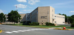 Das Dunn County Government Center in Menomonie
Verwaltung US-Bundesstaat: Wisconsin Verwaltungssitz: Menomonie Adresse des
Verwaltungssitzes:Dunn County Government Center
800 Wilson Avenue
Menomonie, WI 54751-2739Gründung: 1854 Gebildet aus: Chippewa County Vorwahl: 001 715 Demographie Einwohner: 43.857 (2010) Bevölkerungsdichte: 19,9 Einwohner/km² Geographie Fläche gesamt: 2.238 km² Wasserfläche: 31 km² Karte 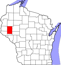
Website: dunncountywi.govoffice2.com Das Dunn County[1] ist ein County im Bundesstaat Wisconsin der Vereinigten Staaten von Amerika. Bei der Volkszählung im Jahr 2010 hatte das County 43.857 Einwohner und eine Bevölkerungsdichte von 19,9 Einwohnern pro Quadratkilometer. Der Verwaltungssitz (County Seat) ist Menomonie, benannt nach dem indianischen Wort für Wilder Reis.
Inhaltsverzeichnis
Geografie
Das County liegt im mittleren Nordwesten von Wisconsin, ist im Westen etwa 50 km von Minnesota entfernt und hat eine Fläche von 2238 Quadratkilometern, wovon 31 Quadratkilometer Wasserfläche sind. Es grenzt an folgende Countys:
Polk County Barron County St. Croix County 
Chippewa County Pierce County Pepin County Eau Claire County Geschichte
Das Dunn County wurde 1854 aus Teilen des Chippewa County gebildet. Benannt wurde es nach Charles Dunn, einem frühen Obersten Richter des Wisconsin-Territoriums.
Demografische Daten
Historische Einwohnerzahlen Census Einwohner ± in % 1900 25.043 — 1910 25.260 0,9 % 1920 26.970 7 % 1930 27.037 0,2 % 1940 27.375 1 % 1950 27.341 -0,1 % 1960 26.156 -4 % 1970 29.154 10 % 1980 34.314 20 % 1990 35.909 5 % 2000 39.858 10 % 2010 43.857 10 % 1900–1990[2] 2010[3] 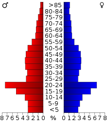 Alterspyramide (2000) des Dunn County
Nach der Volkszählung im Jahr 2000 lebten im Dunn County 39.858 Menschen in 14.337 Haushalten. 9.261 Familien lebten im County. Die Bevölkerungsdichte betrug 18 Personen pro Quadratkilometer. Ethnisch betrachtet setzte sich die Bevölkerung zusammen aus 96,08 Prozent Weißen, 0,34 Prozent Afroamerikanern, 0,27 Prozent amerikanischen Ureinwohnern, 2,13 Prozent Asiaten, 0,01 Prozent Bewohnern aus dem pazifischen Inselraum und 0,37 Prozent aus anderen ethnischen Gruppen; 0,80 Prozent stammten von zwei oder mehr Ethnien ab. 0,84 Prozent der Bevölkerung waren spanischer oder lateinamerikanischer Abstammung, die verschiedenen der genannten Gruppen angehörten.
Von den 14.337 Haushalten hatten 31,4 Prozent Kinder unter 18 Jahren, die mit ihnen zusammen lebten. 54,1 Prozent davon waren verheiratete, zusammenlebende Paare, 6,9 Prozent waren allein erziehende Mütter. 35,4 Prozent waren keine Familien. 24,4 Prozent waren Singlehaushalte und in 9,0 Prozent lebten Menschen mit 65 Jahren oder älter. Die durchschnittliche Haushaltsgröße lag bei 2,57 und die durchschnittliche Familiengröße bei 3,07 Personen.
23,3 Prozent der Bevölkerung waren unter 18 Jahre alt, 19,8 Prozent zwischen 18 und 24, 25,7 Prozent zwischen 25 und 44, 19,8 Prozent zwischen 45 und 64, und 11,2 Prozent waren 65 Jahre oder älter. Das Durchschnittsalter betrug 31 Jahre. Auf 100 weibliche kamen statistisch 101,7 männliche Personen.[5]
Städte und Gemeinden
- Boyceville
- Colfax
- Downing
- Elk Mound
- Knapp
- Menomonie
- Ridgeland
- Tainter Lake
- Wheeler
Einzelnachweise
- ↑ Dunn County im Geographic Names Information System des United States Geological Survey Abgerufen am 22. Februar 2011
- ↑ Auszug aus Census.gov Abgerufen am 28. Februar 2011
- ↑ United States Census 2010 Abgerufen am 16. März 2011
- ↑ Auszug aus dem National Register of Historic Places - Nr. 74000083 Abgerufen am 16. März 2011
- ↑ Dunn County, Wisconsin Datenblatt mit den Ergebnissen der Volkszählung im Jahre 2000 bei factfinder.census.gov
Weblinks
-
 Commons: Dunn County, Wisconsin – Sammlung von Bildern, Videos und Audiodateien
 - Offizielle Webseite
- www.city-data.com

Liste der Countys in Wisconsin
Adams | Ashland | Barron | Bayfield | Brown | Buffalo | Burnett | Calumet | Chippewa | Clark | Columbia | Crawford | Dane | Dodge | Door | Douglas | Dunn | Eau Claire | Florence | Fond du Lac | Forest | Grant | Green | Green Lake | Iowa | Iron | Jackson | Jefferson | Juneau | Kenosha | Kewaunee | La Crosse | Lafayette | Langlade | Lincoln | Manitowoc | Marathon | Marinette | Marquette | Menominee | Milwaukee | Monroe | Oconto | Oneida | Outagamie | Ozaukee | Pepin | Pierce | Polk | Portage | Price | Racine | Richland | Rock | Rusk | Sauk | Sawyer | Shawano | Sheboygan | St. Croix | Taylor | Trempealeau | Vernon | Vilas | Walworth | Washburn | Washington | Waukesha | Waupaca | Waushara | Winnebago | Wood
Wikimedia Foundation.
Schlagen Sie auch in anderen Wörterbüchern nach:
Dunn County, Wisconsin — This article is about the county in Wisconsin. For the county in North Dakota, see Dunn County, North Dakota. Dunn County, Wisconsin Seal … Wikipedia
Dunn, Dunn County, Wisconsin — Dunn, Wisconsin Town Location of Dunn, Wisconsin Coordinates … Wikipedia
New Haven, Dunn County, Wisconsin — New Haven, Wisconsin Town Location of New Haven, Wisconsin … Wikipedia
Otter Creek, Dunn County, Wisconsin — Otter Creek, Wisconsin Town Location of Otter Creek, Wisconsin … Wikipedia
Stanton, Dunn County, Wisconsin — Infobox Settlement official name = Stanton, Wisconsin settlement type = Town nickname = motto = imagesize = image caption = image mapsize = 250px map caption = Location of Stanton, Wisconsin mapsize1 = map caption1 = subdivision type = Country… … Wikipedia
Eau Galle, Dunn County, Wisconsin — Infobox Settlement official name = Eau Galle, Wisconsin settlement type = Town nickname = motto = imagesize = image caption = image mapsize = 250px map caption = Location of Eau Galle, Wisconsin mapsize1 = map caption1 = subdivision type =… … Wikipedia
Grant, Dunn County, Wisconsin — Infobox Settlement official name = Grant, Wisconsin settlement type = Town nickname = motto = imagesize = image caption = image mapsize = 250px map caption = Location of Grant, Wisconsin mapsize1 = map caption1 = subdivision type = Country… … Wikipedia
Sherman, Dunn County, Wisconsin — Infobox Settlement official name = Sherman, Wisconsin settlement type = Town nickname = motto = imagesize = image caption = image mapsize = 250px map caption = Location of Sherman, Wisconsin mapsize1 = map caption1 = subdivision type = Country… … Wikipedia
Weston, Dunn County, Wisconsin — Infobox Settlement official name = Weston, Wisconsin settlement type = Town nickname = motto = imagesize = image caption = image mapsize = 250px map caption = Location of Weston, Wisconsin mapsize1 = map caption1 = subdivision type = Country… … Wikipedia
Wilson, Dunn County, Wisconsin — Infobox Settlement official name = Wilson, Wisconsin settlement type = Town nickname = motto = imagesize = image caption = image mapsize = 250px map caption = Location of Wilson, Wisconsin mapsize1 = map caption1 = subdivision type = Country… … Wikipedia
Dunn County (Wisconsin)


18+
© Academic, 2000-2026
- Kontaktieren Sie uns: Unterstützung, Werbung
Wörterbücher Export, schritte mit PHP, Joomla, Drupal, WordPress, MODx.