- Clark County (Wisconsin)
-
Verwaltung US-Bundesstaat: Wisconsin Verwaltungssitz: Neillsville Adresse des
Verwaltungssitzes:County Courthouse
517 Court Street
Neillsville, WI 54456-1971Gründung: 1853 Gebildet aus: Crawford County Vorwahl: 001 715 Demographie Einwohner: 34.690 (2010) Bevölkerungsdichte: 11 Einwohner/km² Geographie Fläche gesamt: 3.157 km² Wasserfläche: 9 km² Karte 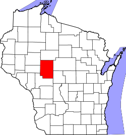
Website: www.co.clark.wi.us Clark County[1] ist ein County im Bundesstaat Wisconsin der Vereinigten Staaten von Amerika. Bei der Volkszählung im Jahr 2010 hatte das County 34690 Einwohner und eine Bevölkerungsdichte von 11 Einwohnern pro Quadratkilometer. Der Verwaltungssitz (County Seat) ist Neillsville.
Inhaltsverzeichnis
Geografie
Das County liegt etwas nordwestlich des geographischen Zentrums von Wisconsin und hat eine Fläche von 3157 Quadratkilometern, wovon 9 Quadratkilometer Wasserfläche sind. Es grenzt an folgende Countys:
Chippewa County Taylor County Eau Claire County 
Marathon County Jackson County Wood County Geschichte
Clark County wurde 1853 aus Teilen des Crawford County gebildet. Benannt wurde es nach George Rogers Clark, einem General im Amerikanischen Unabhängigkeitskrieg oder nach A. W. Clark, dem Gründer von Clark's Mill im Nordwesten Wisconsins.
Demografische Daten
Historische Einwohnerzahlen Census Einwohner ± in % 1900 25.848 — 1910 30.074 20 % 1920 35.120 20 % 1930 34.165 -3 % 1940 33.972 -0,6 % 1950 32.459 -4 % 1960 31.527 -3 % 1970 30.361 -4 % 1980 32.910 8 % 1990 31.647 -4 % 2000 33.557 6 % 2010 34.690 3 % 1900–1990[2] 2010[3] 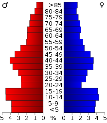 Alterspyramide (2000) des Clark County
Nach der Volkszählung im Jahr 2000 lebten im Clark County 33.557 Menschen in 12.047 Haushalten. 8.673 Familien lebten im County. Die Bevölkerungsdichte betrug 11 Personen pro Quadratkilometer. Ethnisch betrachtet setzte sich die Bevölkerung zusammen aus 98,05 Prozent Weißen, 0,13 Prozent Afroamerikanern, 0,48 Prozent amerikanischen Ureinwohnern, 0,30 Prozent Asiaten, 0,01 Prozent Bewohnern aus dem pazifischen Inselraum und 0,56 Prozent aus anderen ethnischen Gruppen; 0,47 Prozent stammten von zwei oder mehr Ethnien ab. 1,20 Prozent der Bevölkerung waren spanischer oder lateinamerikanischer Abstammung, die verschiedenen der genannten Gruppen angehörten.
Von den 12.047 Haushalten hatten 35,0 Prozent Kinder unter 18 Jahren, die mit ihnen zusammen lebten. 61,2 Prozent davon waren verheiratete, zusammenlebende Paare, 6,5 Prozent waren allein erziehende Mütter. 28,0 Prozent waren keine Familien. 23,8 Prozent waren Singlehaushalte und in 12,6 Prozent lebten Menschen mit 65 Jahren oder älter. Die durchschnittliche Haushaltsgröße betrug 2,73 und die durchschnittliche Familiengröße lag bei 3,27 Personen.
29,9 Prozent der Bevölkerung waren unter 18 Jahre alt, 7,7 Prozent zwischen 18 und 24, 26,2 Prozent zwischen 25 und 44, 20,2 Prozent zwischen 45 und 64, und 16,0 Prozent waren 65 Jahre oder älter. Das Durchschnittsalter betrug 36 Jahre. Auf 100 weibliche kamen statistisch 100,5 männliche Personen. [4]
Städte und Gemeinden
- Abbotsford1
- Colby1
- Curtiss
- Dorchester1
- Granton
- Greenwood
- Loyal
- Neillsville
- Owen
- Stanley2
- Thorp
- Unity1
- Withee
1 - teilweise im Marathon County
2 - teilweise im Chippewa CountyEinzelnachweise
- ↑ Clark County im Geographic Names Information System des United States Geological Survey. Abgerufen am 22. Februar 2011
- ↑ Auszug aus Census.gov Abgerufen am 28. Februar 2011
- ↑ United States Census 2010 Abgerufen am 16. März 2011
- ↑ Clark County, Wisconsin, Datenblatt mit den Ergebnissen der Volkszählung im Jahre 2000 bei factfinder.census.gov.
Weblinks
-
 Commons: Clark County, Wisconsin – Sammlung von Bildern, Videos und Audiodateien
 - Offizielle Webseite
- www.city-data.com

Liste der Countys in Wisconsin
Adams | Ashland | Barron | Bayfield | Brown | Buffalo | Burnett | Calumet | Chippewa | Clark | Columbia | Crawford | Dane | Dodge | Door | Douglas | Dunn | Eau Claire | Florence | Fond du Lac | Forest | Grant | Green | Green Lake | Iowa | Iron | Jackson | Jefferson | Juneau | Kenosha | Kewaunee | La Crosse | Lafayette | Langlade | Lincoln | Manitowoc | Marathon | Marinette | Marquette | Menominee | Milwaukee | Monroe | Oconto | Oneida | Outagamie | Ozaukee | Pepin | Pierce | Polk | Portage | Price | Racine | Richland | Rock | Rusk | Sauk | Sawyer | Shawano | Sheboygan | St. Croix | Taylor | Trempealeau | Vernon | Vilas | Walworth | Washburn | Washington | Waukesha | Waupaca | Waushara | Winnebago | Wood
Wikimedia Foundation.
Schlagen Sie auch in anderen Wörterbüchern nach:
Clark County, Wisconsin — Location in the state of Wisconsin … Wikipedia
National Register of Historic Places listings in Clark County, Wisconsin — Buildings, sites, districts, and objects in Clark County listed on the National Register of Historic Places See also: National Register of Historic Places listings in Wisconsin This National Park Service list is complete through NPS recent… … Wikipedia
Mayville, Clark County, Wisconsin — Mayville, Wisconsin Town Location of Mayville, Wisconsin … Wikipedia
Clark County Sheriff's Department — can refer to the following law enforcement units: Clark County Sheriff s Department (Illinois) Clark County, Illinois Clark County Sheriff s Department (Kentucky) Clark County, Kentucky Clark County Sheriff s Department (Nevada) Clark County,… … Wikipedia
Fremont, Clark County, Wisconsin — Infobox Settlement official name = Fremont, Wisconsin settlement type = Town nickname = motto = imagesize = image caption = image mapsize = 250px map caption = Location of Fremont, Wisconsin mapsize1 = map caption1 = subdivision type = Country… … Wikipedia
Washburn, Clark County, Wisconsin — There is also the City of Washburn and the Town of Wasburn in Bayfield County. Infobox Settlement official name = Washburn, Wisconsin settlement type = Town nickname = motto = imagesize = image caption = image mapsize = 250px map caption =… … Wikipedia
Clark County — is the name of twelve counties in the United States of America. Most, though not all, are named after two brothers: military hero George Rogers Clark in the Midwest, and explorer William Clark in the West. Clark County, Arkansas Clark County,… … Wikipedia
York, Clark County, Wisconsin — There are two other towns named York, Wisconsin; for places elsewhere in the world named York, see York (disambiguation). Infobox Settlement official name = York, Wisconsin settlement type = Town nickname = motto = imagesize = image caption =… … Wikipedia
Unity, Clark County, Wisconsin — There is also the Town of Unity in Trempealeau County. Infobox Settlement official name = Unity, Wisconsin settlement type = Town nickname = motto = imagesize = image caption = image mapsize = map caption = mapsize1 = map caption1 = subdivision… … Wikipedia
Beaver, Clark County, Wisconsin — Infobox Settlement official name = Beaver, Wisconsin settlement type = Town nickname = motto = imagesize = image caption = image mapsize = 250px map caption = Location of Beaver, Wisconsin mapsize1 = map caption1 = subdivision type = Country… … Wikipedia
Clark County (Wisconsin)


18+
© Academic, 2000-2026
- Kontaktieren Sie uns: Unterstützung, Werbung
Wörterbücher Export, schritte mit PHP, Joomla, Drupal, WordPress, MODx.