- Hand County
-
Verwaltung US-Bundesstaat: South Dakota Verwaltungssitz: Miller Gründung: 1873 Demographie Einwohner: 3741 (2000) Bevölkerungsdichte: 2,6 Einwohner/km² Geographie Fläche gesamt: 1.440 km² Wasserfläche: 9 km² Karte 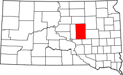
Hand County[1] ist ein County im Bundesstaat South Dakota der Vereinigten Staaten von Amerika.
Inhaltsverzeichnis
Geographie
Der Bezirk hat eine Fläche von 1440 Quadratkilometern; davon sind 9 Quadratkilometer (0,25 Prozent) Wasserflächen. Er ist in 40 Townships eingeteilt: Alden, Alpha, Bates, Burdette, Campbell, Carlton, Cedar, Como, Florence, Gilbert, Glendale, Grand, Greenleaf, Hiland, Holden, Hulbert, Linn, Logan, Midland, Miller, Mondamin, Ohio, Ontario, Park, Pearl, Plato, Pleasant Valley, Ree Heights, Riverside, Rockdale, Rose Hill, St. Lawrence, Spring Hill, Spring Lake, Wheaton und York; sowie ein unorganisiertes Territorium: Northwest Hand.
Bevölkerungsentwicklung
Historische Einwohnerzahlen Census Einwohner ± in % 1900 4525 — 1910 7870 70 % 1920 8778 10 % 1930 9485 8 % 1940 7166 -20 % 1950 7149 -0,2 % 1960 6712 -6 % 1970 5883 -10 % 1980 4948 -20 % 1990 4272 -10 % 2000 3741 -10 % 2010 3431 -8 % 1900–1990[2] 2000[3]
Städte und Gemeinden
Städte (cities)
- Miller
Gemeinden (towns)
- Ree Heights
- St. Lawrence
Einzelnachweise
- ↑ Hand County im Geographic Names Information System des United States Geological Survey. Abgerufen am 22. Februar 2011
- ↑ Auszug aus Census.gov. Abgerufen am 28. Februar 2011
- ↑ Auszug aus factfinder.census.gov Abgerufen am 28. Februar 2011

Liste der Countys in South Dakota
Aurora | Beadle | Bennett | Bon Homme | Brookings | Brown | Brule | Buffalo | Butte | Campbell | Charles Mix | Clark | Clay | Codington | Corson | Custer | Davison | Day | Deuel | Dewey | Douglas | Edmunds | Fall River | Faulk | Grant | Gregory | Haakon | Hamlin | Hand | Hanson | Harding | Hughes | Hutchinson | Hyde | Jackson | Jerauld | Jones | Kingsbury | Lake | Lawrence | Lincoln | Lyman | Marshall | McCook | McPherson | Meade | Mellette | Miner | Minnehaha | Moody | Pennington | Perkins | Potter | Roberts | Sanborn | Shannon | Spink | Stanley | Sully | Todd | Tripp | Turner | Union | Walworth | Yankton | Ziebach
Wikimedia Foundation.
Schlagen Sie auch in anderen Wörterbüchern nach:
Hand County — Admin ASC 2 Code Orig. name Hand County Country and Admin Code US.SD.059 US … World countries Adminstrative division ASC I-II
Hand County, South Dakota — Infobox U.S. County county = Hand County state = South Dakota founded year = 1873 founded date = seat wl = Miller largest city wl = Miller area total sq mi = 1440 area total km2 = 3730 area land sq mi = 1437 area land km2 = 3721 area water sq mi … Wikipedia
National Register of Historic Places listings in Hand County, South Dakota — Location of Hand County in South Dakota This is a list of the National Register of Historic Places listings in Hand County, South Dakota. This is intended to be a complete list of the properties on the National Register of Historic Places in Hand … Wikipedia
Hand (disambiguation) — Hands are the two intricate, prehensile, multi fingered body parts normally located at the end of each arm of a human or other primate. There are four fingers and a thumb (counting up to five digits) on the human hand.Hand may also refer to:*… … Wikipedia
Hand (Begriffsklärung) — Hand steht für: Hand, einen menschlichen Körperteil, Hand (Maßeinheit), alte von der Breite der Hand oder Handfläche abgeleitete Längenmaße Hand (Poker), im Kartenspiel die Anreihung der besten fünf Karten, Hand (Heraldik) gemeine Figur in der… … Deutsch Wikipedia
County attorney — A county attorney in many areas of the United States is the chief legal officer for a county or local judicial district. It is usually an elected position. The role of the county attorney can be similar to or complementary to that of a local… … Wikipedia
County Hospital (1932 film) — County Hospital Publicity shot for the film Directed by James Parrott Produ … Wikipedia
County Limerick — Contae Luimneach Coat of arms … Wikipedia
County Route 83 (Suffolk County, New York) — County Route 83 Route information Maintained by SCDPW Length: 11.55 mi … Wikipedia
County collecting — is keeping track of the counties and other major census divisions one has visited in the United States. Many county collectors try to go for blackout, to visit every county unit in the United States. Others try to black out individual states, and … Wikipedia
Hand County

18+
© Academic, 2000-2026
- Kontaktieren Sie uns: Unterstützung, Werbung
Wörterbücher Export, schritte mit PHP, Joomla, Drupal, WordPress, MODx.