- Day County
-
Verwaltung US-Bundesstaat: South Dakota Verwaltungssitz: Webster Gründung: 1880 Demographie Einwohner: 6267 (2000) Bevölkerungsdichte: 2,4 Einwohner/km² Geographie Fläche gesamt: 2.826 km² Wasserfläche: 162 km² Karte 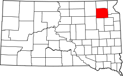
Day County[1] ist ein County im Bundesstaat South Dakota der Vereinigten Staaten von Amerika. Es liegt im Nordosten des Bundesstaates und hat 6267 Einwohner. Das County wurde nach Merritt H. Day benannt, einem Politiker im Dakota-Territorium.
Inhaltsverzeichnis
Geographie
Der Bezirk hat eine Fläche von 2826 Quadratkilometern; davon sind 162 Quadratkilometer (5,74 Prozent) Wasserflächen. Er ist in 28 Townships eingeteilt: Andover, Bristol, Butler, Central Point, Egeland, Farmington, Grenville, Highland, Home, Independence, Kidder, Kosciusko, Liberty, Lynn, Morton, Nutley, Oak Gulch, Racine, Raritan, Rusk, Scotland, Troy, Union, Valley, Waubay, Webster, Wheatland und York.
Bevölkerungsentwicklung
Historische Einwohnerzahlen Census Einwohner ± in % 1900 12.254 — 1910 14.372 20 % 1920 15.194 6 % 1930 14.606 -4 % 1940 13.565 -7 % 1950 12.294 -9 % 1960 10.516 -10 % 1970 8713 -20 % 1980 8133 -7 % 1990 6978 -10 % 2000 6267 -10 % 2010 5710 -9 % 1900–1990[2] 2000[3]
Städte und Gemeinden
Städte (cities)
- Bristol
- Waubay
- Webster
Gemeinden (towns)
- Andover
- Butler
- Grenville
- Lily
- Pierpont
- Roslyn
Gemeindefreie Dörfer
- Crandall
Einzelnachweise
- ↑ Day County im Geographic Names Information System des United States Geological Survey. Abgerufen am 22. Februar 2011
- ↑ Auszug aus Census.gov. Abgerufen am 28. Februar 2011
- ↑ Auszug aus factfinder.census.gov Abgerufen am 28. Februar 2011

Liste der Countys in South Dakota
Aurora | Beadle | Bennett | Bon Homme | Brookings | Brown | Brule | Buffalo | Butte | Campbell | Charles Mix | Clark | Clay | Codington | Corson | Custer | Davison | Day | Deuel | Dewey | Douglas | Edmunds | Fall River | Faulk | Grant | Gregory | Haakon | Hamlin | Hand | Hanson | Harding | Hughes | Hutchinson | Hyde | Jackson | Jerauld | Jones | Kingsbury | Lake | Lawrence | Lincoln | Lyman | Marshall | McCook | McPherson | Meade | Mellette | Miner | Minnehaha | Moody | Pennington | Perkins | Potter | Roberts | Sanborn | Shannon | Spink | Stanley | Sully | Todd | Tripp | Turner | Union | Walworth | Yankton | Ziebach
Wikimedia Foundation.
Schlagen Sie auch in anderen Wörterbüchern nach:
Day County — Admin ASC 2 Code Orig. name Day County Country and Admin Code US.SD.037 US … World countries Adminstrative division ASC I-II
Day County, South Dakota — Location in the state of South Dakota … Wikipedia
Day County, Oklahoma Territory — Map of Day County in 1905 Day County was one of the original counties of Oklahoma Territory. Day County was in the western part of the territory, along the Texas border. When it was originally established, it was known as E County (several… … Wikipedia
National Register of Historic Places listings in Day County, South Dakota — Location of Day County in South Dakota This is a list of the National Register of Historic Places listings in Day County, South Dakota. This is intended to be a complete list of the properties and districts on the National Register of Historic… … Wikipedia
County roads in Hennepin County, Minnesota — Hennepin County, Minnesota, United States maintains a number of county routes, many of them county state aid highways (CSAH). This includes a number of streets through the city of Minneapolis. Contents 1 CR 1–CR 25 2 CR 26–CR 50 3 CR 51–CR 75 … Wikipedia
County Tyrone — Tyrone redirects here. For other uses, see Tyrone (disambiguation). County Tyrone Contae Thír Eoghain Coontie Tyrone … Wikipedia
County Road 46 (Essex County, Ontario) — Infobox road highway name = Essex County Road 46 alternate name = Provincial Road, Middle Road, Essex County Road 46, Chatham Kent Road 8 marker length km = 96.2 length notes = Continues eastward as Chatham Kent Municipal Road 8 maint =… … Wikipedia
Day (disambiguation) — A day is a unit of temporal measurement for a literal day or epoch of time. Day, DAY or Days may also refer to: Contents 1 Temporal 2 Culture and entertainment … Wikipedia
Day-care sex-abuse hysteria — was a panic that occurred primarily in the 1980s and early 1990s featuring claims against daycare providers of satanic ritual abuse and several forms of child abuse.[1][2] A prominent case in Kern County, California, first brought the issue of… … Wikipedia
County Connection — Bus 404 on then Route 126 at BART Orinda Founded 1980 … Wikipedia
Day County

18+
© Academic, 2000-2026
- Kontaktieren Sie uns: Unterstützung, Werbung
Wörterbücher Export, schritte mit PHP, Joomla, Drupal, WordPress, MODx.