- Custer County (South Dakota)
-
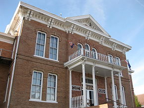 Custer County Courthouse in Custer
Verwaltung US-Bundesstaat: South Dakota Verwaltungssitz: Custer Gründung: 1875 Demographie Einwohner: 7275 (2000) Bevölkerungsdichte: 1,8 Einwohner/km² Geographie Fläche gesamt: 4.038 km² Wasserfläche: 4 km² Karte 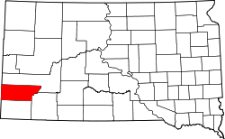
Website: www.custercountysd.com Custer County[1] ist ein County im Bundesstaat South Dakota der Vereinigten Staaten von Amerika. Das County hat 7275 Einwohner. Der Verwaltungssitz (County Seat) ist Custer.
Inhaltsverzeichnis
Geographie
Der Bezirk hat eine Fläche von 4038 Quadratkilometern; davon sind 4 Quadratkilometer (0,09 Prozent) Wasserflächen. Er wird in zwei unorganisierte Territorien eingeteilt: East of Custer State Park and West of Custer State Park Custer.
Bevölkerungsentwicklung
Historische Einwohnerzahlen Census Einwohner ± in % 1900 2728 — 1910 4458 60 % 1920 3907 -10 % 1930 5353 40 % 1940 6023 10 % 1950 5517 -8 % 1960 4906 -10 % 1970 4698 -4 % 1980 6000 30 % 1990 6179 3 % 2000 7275 20 % 2010 8216 10 % 1900–1990[2] 2000[3]
Städte und Gemeinden
Städte (cities)
Gemeinden (towns)
- Buffalo Gap
- Fairburn
- Hermosa
- Pringle
Schutzgebiete
- Black Hills National Forest (partiell)
- Buffalo Gap National Grassland (partiell)
- Custer State Park
- Jewel Cave National Monument
- Wind-Cave-Nationalpark
Einzelnachweise
- ↑ Custer County im Geographic Names Information System des United States Geological Survey. Abgerufen am 22. Februar 2011
- ↑ Auszug aus Census.gov. Abgerufen am 28. Februar 2011
- ↑ Auszug aus factfinder.census.gov Abgerufen am 28. Februar 2011

Liste der Countys in South Dakota
Aurora | Beadle | Bennett | Bon Homme | Brookings | Brown | Brule | Buffalo | Butte | Campbell | Charles Mix | Clark | Clay | Codington | Corson | Custer | Davison | Day | Deuel | Dewey | Douglas | Edmunds | Fall River | Faulk | Grant | Gregory | Haakon | Hamlin | Hand | Hanson | Harding | Hughes | Hutchinson | Hyde | Jackson | Jerauld | Jones | Kingsbury | Lake | Lawrence | Lincoln | Lyman | Marshall | McCook | McPherson | Meade | Mellette | Miner | Minnehaha | Moody | Pennington | Perkins | Potter | Roberts | Sanborn | Shannon | Spink | Stanley | Sully | Todd | Tripp | Turner | Union | Walworth | Yankton | Ziebach
Wikimedia Foundation.
Schlagen Sie auch in anderen Wörterbüchern nach:
Custer County, South Dakota — Location in the state of South Dakota … Wikipedia
National Register of Historic Places listings in Custer County, South Dakota — Location of Custer County in South Dakota … Wikipedia
Minnehaha County (South Dakota) — Verwaltung US Bundesstaat: South Dakota Verwaltungssitz: Sioux Falls Adresse des Verwaltungssitzes: Gründung … Deutsch Wikipedia
Ziebach County (South Dakota) — Verwaltung US Bundesstaat: South Dakota Verwaltungssitz: Dupree Adresse des Verwaltungssitzes: Gründung … Deutsch Wikipedia
Pennington County, South Dakota — Infobox U.S. County county = Pennington County state = South Dakota founded year = founded date = seat wl = Rapid City largest city wl = Rapid City area total sq mi = 2784 area total km2 = 7211 area land sq mi =2776 area land km2 = 7190 area… … Wikipedia
Shannon County, South Dakota — Infobox U.S. County county = Shannon County state = South Dakota founded year = founded date = seat wl = largest city wl = Pine Ridge area total sq mi = 2097 area total km2 = 5430 area land sq mi = 2094 area land km2 = 5423 area water sq mi = 3… … Wikipedia
Fall River County, South Dakota — Infobox U.S. County county = Fall River County state = South Dakota founded year = founded date = seat wl = Hot Springs largest city wl = area total sq mi = 1749 area total km2 = 4530 area land sq mi = 1740 area land km2 = 4506 area water sq mi … Wikipedia
Corson County, South Dakota — Corson County Courthouse in McIntosh, South Dakota in 1993. This building was destroyed by fire on April 10, 2006 … Wikipedia
Clay County, South Dakota — Location in the state of South Dakota … Wikipedia
Union County, South Dakota — Location in the state of South Dakota … Wikipedia
Custer County (South Dakota)


18+
© Academic, 2000-2026
- Kontaktieren Sie uns: Unterstützung, Werbung
Wörterbücher Export, schritte mit PHP, Joomla, Drupal, WordPress, MODx.