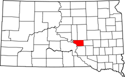
- Buffalo County (South Dakota)
-
Verwaltung US-Bundesstaat: South Dakota Verwaltungssitz: Gann Valley Gründung: 1873 Demographie Einwohner: 2032 (2000) Bevölkerungsdichte: 1,7 Einwohner/km² Geographie Fläche gesamt: 1.262 km² Wasserfläche: 44 km² Karte Buffalo County[1] ist ein Bezirk im Bundesstaat South Dakota der Vereinigten Staaten von Amerika. Es hat 2.032 Einwohner. Der Verwaltungssitz (County Seat) ist Gann Valley.
Inhaltsverzeichnis
Geografie
Das County hat eine Fläche von 1262 Quadratkilometern; davon sind 44 Quadratkilometer (3,45 Prozent) Wasserflächen.
Bevölkerungsentwicklung
Historische Einwohnerzahlen Census Einwohner ± in % 1900 1790 — 1910 1589 -10 % 1920 1715 8 % 1930 1931 10 % 1940 1853 -4 % 1950 1615 -10 % 1960 1547 -4 % 1970 1739 10 % 1980 1795 3 % 1990 1759 -2 % 2000 2032 20 % 2010 1912 -6 % 1900–1990[2] 2000[3]
Dörfer
Einzelnachweise
- ↑ Buffalo County im Geographic Names Information System des United States Geological Survey. Abgerufen am 22. Februar 2011
- ↑ Auszug aus Census.gov. Abgerufen am 28. Februar 2011
- ↑ Auszug aus factfinder.census.gov Abgerufen am 28. Februar 2011
Liste der Countys in South Dakota
Aurora | Beadle | Bennett | Bon Homme | Brookings | Brown | Brule | Buffalo | Butte | Campbell | Charles Mix | Clark | Clay | Codington | Corson | Custer | Davison | Day | Deuel | Dewey | Douglas | Edmunds | Fall River | Faulk | Grant | Gregory | Haakon | Hamlin | Hand | Hanson | Harding | Hughes | Hutchinson | Hyde | Jackson | Jerauld | Jones | Kingsbury | Lake | Lawrence | Lincoln | Lyman | Marshall | McCook | McPherson | Meade | Mellette | Miner | Minnehaha | Moody | Pennington | Perkins | Potter | Roberts | Sanborn | Shannon | Spink | Stanley | Sully | Todd | Tripp | Turner | Union | Walworth | Yankton | Ziebach
Wikimedia Foundation.
Schlagen Sie auch in anderen Wörterbüchern nach:
Buffalo County, South Dakota — Infobox U.S. County county = Buffalo County state = South Dakota founded year = founded date = seat wl = Gannvalley largest city wl = area total sq mi = 487 area total km2 = 1262 area land sq mi = 471 area land km2 = 1219 area water sq mi = 17… … Wikipedia
National Register of Historic Places listings in Buffalo County, South Dakota — Location of Buffalo County in South Dakota This is a list of the National Register of Historic Places listings in Buffalo County, South Dakota. This is intended to be a complete list of the properties and districts on the National Register of… … Wikipedia
Buffalo Gap, South Dakota — Infobox Settlement official name = Buffalo Gap other name = native name = nickname = settlement type = Town motto = imagesize = image caption = flag size = image seal size = image shield = shield size = image blank emblem = blank emblem type =… … Wikipedia
Minnehaha County (South Dakota) — Verwaltung US Bundesstaat: South Dakota Verwaltungssitz: Sioux Falls Adresse des Verwaltungssitzes: Gründung … Deutsch Wikipedia
Ziebach County (South Dakota) — Verwaltung US Bundesstaat: South Dakota Verwaltungssitz: Dupree Adresse des Verwaltungssitzes: Gründung … Deutsch Wikipedia
Lyman County, South Dakota — Infobox U.S. County county = Lyman County state = South Dakota founded year = founded date = seat wl = Kennebec largest city wl = area total sq mi = 1707 area total km2 = 4421 area land sq mi =1640 area land km2 = 4247 area water sq mi = 67 area… … Wikipedia
Jerauld County, South Dakota — Infobox U.S. County county = Jerauld County state = South Dakota founded year = founded date = seat wl = Wessington Springs largest city wl = area total sq mi = 533 area total km2 = 1380 area land sq mi =530 area land km2 = 1372 area water sq mi … Wikipedia
Hyde County, South Dakota — Infobox U.S. County county = Hyde County state = South Dakota founded year = founded date = seat wl = Highmore largest city wl = area total sq mi = 867 area total km2 = 2244 area land sq mi =861 area land km2 = 2230 area water sq mi = 6 area… … Wikipedia
Hand County, South Dakota — Infobox U.S. County county = Hand County state = South Dakota founded year = 1873 founded date = seat wl = Miller largest city wl = Miller area total sq mi = 1440 area total km2 = 3730 area land sq mi = 1437 area land km2 = 3721 area water sq mi … Wikipedia
Brule County, South Dakota — Infobox U.S. County county = Brule County state = South Dakota founded year = founded date = seat wl = Chamberlain largest city wl = area total sq mi = 846 area total km2 = 2192 area land sq mi = 819 area land km2 = 2121 area water sq mi = 28… … Wikipedia