- Pennington County (South Dakota)
-
Verwaltung US-Bundesstaat: South Dakota Verwaltungssitz: Rapid City Adresse des
Verwaltungssitzes:Pennington County Courthouse
315 Saint Joseph Street
Rapid City, SD 57701101 EGründung: 1875 Demographie Einwohner: 92.776 (2006) Bevölkerungsdichte: 12,9 Einwohner/km² Geographie Fläche gesamt: 7.211 km² Wasserfläche: 21 km² Karte 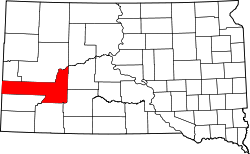
Website: www.co.pennington.sd.us/ Pennington County[1] ist ein County im Bundesstaat South Dakota der Vereinigten Staaten von Amerika. Im Jahre 2006 betrug die Bevölkerung 92.776 Einwohner. Der Verwaltungssitz (County Seat) ist Rapid City, der zweitgrößten Stadt in South Dakota.
Inhaltsverzeichnis
Geschichte
Pennington County wurde 1875 gegründet und ist nach John L. Pennington, dem damaligen Gouverneur des Dakota Territory benannt.
Geographie
 Der Mount Rushmore
Die Fläche des Countys beträgt 7211 Quadratkilometer. Davon sind 21 Quadratkilometer (0,29 Prozent) Wasserfläche. Das County grenzt im Uhrzeigersinn an folgende andere Countys: Meade County, Haakon County, Jackson County, Shannon County, Custer County, Weston County in Wyoming und Lawrence County.
Im Gebiet des Countys befindet sich der Mount Rushmore. In diesen Berg wurden Abbilder der Köpfe von vier US-Präsidenten gehauen. Auch der Harney Peak, der höchste Berg Süddakotas, befindet sich in Pennington County
Bevölkerungsentwicklung
Historische Einwohnerzahlen Census Einwohner ± in % 1900 5610 — 1910 12.453 100 % 1920 12.720 2 % 1930 20.079 60 % 1940 23.799 20 % 1950 34.053 40 % 1960 58.195 70 % 1970 59.349 2 % 1980 70.361 20 % 1990 81.343 20 % 2000 88.565 9 % 2010 100.948 10 % 1900–1990[2] 2000[3]
Städte und Gemeinden
Städte (cities)
- Hill City
- New Underwood
- Rapid City
Gemeinden (towns)
- Keystone
- Quinn
- Wall
- Wasta
Townships
Das County ist in 20 Townships eingeteilt: Ash, Castle Butte, Cedar Butte, Conata, Crooked Creed, Fairview, Flat Butte, Huron, Imlay, Lake Creek, Lake Flat, Lake Hill, Owanka, Peno, Quinn, Rainy Creek/Cheyenne, Scenic, Shyne, Sunnyside und Wasta; sowie sieben unorganisierte Territorien: Central Pennington, Dalzell Canyon, East Central Pennington, Mount Rushmore, Northeast Pennington, Rapid City East und West Pennington.
Einzelnachweise
- ↑ Pennington County im Geographic Names Information System des United States Geological Survey. Abgerufen am 22. Februar 2011
- ↑ Auszug aus Census.gov. Abgerufen am 28. Februar 2011
- ↑ Auszug aus factfinder.census.gov Abgerufen am 28. Februar 2011

Liste der Countys in South Dakota
Aurora | Beadle | Bennett | Bon Homme | Brookings | Brown | Brule | Buffalo | Butte | Campbell | Charles Mix | Clark | Clay | Codington | Corson | Custer | Davison | Day | Deuel | Dewey | Douglas | Edmunds | Fall River | Faulk | Grant | Gregory | Haakon | Hamlin | Hand | Hanson | Harding | Hughes | Hutchinson | Hyde | Jackson | Jerauld | Jones | Kingsbury | Lake | Lawrence | Lincoln | Lyman | Marshall | McCook | McPherson | Meade | Mellette | Miner | Minnehaha | Moody | Pennington | Perkins | Potter | Roberts | Sanborn | Shannon | Spink | Stanley | Sully | Todd | Tripp | Turner | Union | Walworth | Yankton | Ziebach
Wikimedia Foundation.
Schlagen Sie auch in anderen Wörterbüchern nach:
Pennington County, South Dakota — Infobox U.S. County county = Pennington County state = South Dakota founded year = founded date = seat wl = Rapid City largest city wl = Rapid City area total sq mi = 2784 area total km2 = 7211 area land sq mi =2776 area land km2 = 7190 area… … Wikipedia
National Register of Historic Places listings in Pennington County, South Dakota — Location of Pennington County in South Dakota This is a list of the National Register of Historic Places listings in Pennington County, South Dakota. This is intended to be a complete list of the properties and districts on the National Register… … Wikipedia
Meade County, South Dakota — Location in the state of South Dakota … Wikipedia
Jackson County, South Dakota — Location in the state of South Dakota … Wikipedia
Custer County, South Dakota — Location in the state of South Dakota … Wikipedia
Minnehaha County (South Dakota) — Verwaltung US Bundesstaat: South Dakota Verwaltungssitz: Sioux Falls Adresse des Verwaltungssitzes: Gründung … Deutsch Wikipedia
Ziebach County (South Dakota) — Verwaltung US Bundesstaat: South Dakota Verwaltungssitz: Dupree Adresse des Verwaltungssitzes: Gründung … Deutsch Wikipedia
Haakon County, South Dakota — Infobox U.S. County county = Haakon County state = South Dakota founded year = founded date = seat wl = Philip largest city wl = area total sq mi = 1827 area total km2 = 4732 area land sq mi =1813 area land km2 = 4696 area water sq mi = 14 area… … Wikipedia
Shannon County, South Dakota — Infobox U.S. County county = Shannon County state = South Dakota founded year = founded date = seat wl = largest city wl = Pine Ridge area total sq mi = 2097 area total km2 = 5430 area land sq mi = 2094 area land km2 = 5423 area water sq mi = 3… … Wikipedia
Lawrence County, South Dakota — Infobox U.S. County county = Lawrence County state = South Dakota founded year = founded date = seat wl = Deadwood largest city wl = area total sq mi = 800 area total km2 = 2073 area land sq mi = 800 area land km2 = 2072 area water sq mi … Wikipedia
Pennington County (South Dakota)


18+
© Academic, 2000-2026
- Kontaktieren Sie uns: Unterstützung, Werbung
Wörterbücher Export, schritte mit PHP, Joomla, Drupal, WordPress, MODx.