- Union County (South Dakota)
-
Verwaltung US-Bundesstaat: South Dakota Verwaltungssitz: Elk Point Gründung: 1862 Demographie Einwohner: 12.584 (2000) Bevölkerungsdichte: 10,5 Einwohner/km² Geographie Fläche gesamt: 1.210 km² Wasserfläche: 17 km² Karte 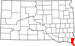
Union County[1] ist ein County im Bundesstaat South Dakota der Vereinigten Staaten von Amerika. Der Sitz der Countyverwaltung (County Seat) ist in Elk Point.
Inhaltsverzeichnis
Geographie
Das County hat eine Fläche von 1.210 Quadratkilometern; davon sind 17 Quadratkilometer (1,43 Prozent) Wasserflächen.
Bevölkerungsentwicklung
Historische Einwohnerzahlen Census Einwohner ± in % 1900 11.153 — 1910 10.676 -4 % 1920 11.099 4 % 1930 11.480 3 % 1940 11.675 2 % 1950 10.792 -8 % 1960 10.197 -6 % 1970 9643 -5 % 1980 10.938 10 % 1990 10.189 -7 % 2000 12.584 20 % 2010 14.399 10 % 1900–1990[2] 2000[3]
Städte und Gemeinden
Das County besteht aus folgenden Städten (Citys):
- Alcaster
- Beresford
- Elk Point
- Jefferson
- Richland
- Spink
Townships
Der Bezirk ist eingeteilt in zwölf Townships: Alcester, Big Sioux, Big Springs, Brule, Civil Bend, Elk Point, Emmet, Jefferson, Pairie, Sioux Valley, Sping, Virginia; und ein unorganisiertes Territorium: Richland.
Einzelnachweise
- ↑ Union County im Geographic Names Information System des United States Geological Survey. Abgerufen am 22. Februar 2011
- ↑ Auszug aus Census.gov. Abgerufen am 28. Februar 2011
- ↑ Auszug aus factfinder.census.gov Abgerufen am 28. Februar 2011

Liste der Countys in South Dakota
Aurora | Beadle | Bennett | Bon Homme | Brookings | Brown | Brule | Buffalo | Butte | Campbell | Charles Mix | Clark | Clay | Codington | Corson | Custer | Davison | Day | Deuel | Dewey | Douglas | Edmunds | Fall River | Faulk | Grant | Gregory | Haakon | Hamlin | Hand | Hanson | Harding | Hughes | Hutchinson | Hyde | Jackson | Jerauld | Jones | Kingsbury | Lake | Lawrence | Lincoln | Lyman | Marshall | McCook | McPherson | Meade | Mellette | Miner | Minnehaha | Moody | Pennington | Perkins | Potter | Roberts | Sanborn | Shannon | Spink | Stanley | Sully | Todd | Tripp | Turner | Union | Walworth | Yankton | Ziebach
Wikimedia Foundation.
Schlagen Sie auch in anderen Wörterbüchern nach:
Union County, South Dakota — Location in the state of South Dakota … Wikipedia
National Register of Historic Places listings in Union County, South Dakota — Location of Union County in South Dakota This is a list of the National Register of Historic Places listings in Union County, South Dakota. This is intended to be a complete list of the properties and districts on the National Register of… … Wikipedia
Emmet Township, Union County, South Dakota — Emmet Township is a township in Union County, South Dakota, United States. The population was 257 at the 2000 census.GeographyAccording to the United States Census Bureau, the township has a total area of 36.0 square miles (93.24 km²), of which,… … Wikipedia
Saint John Cemetery (Union County, South Dakota) — See also Saint John Cemetery. St. John Cemetery is a Catholic cemetery located in Prairie Township, Union County, South Dakota. The cemetery is one of four adjacent cemeteries, which are a mile south and a mile east of Beresford, South Dakota. Of … Wikipedia
Union Center, South Dakota — Union Center is an unincorporated community in Meade County, South Dakota, United States. Although not tracked by the Census Bureau, Union Center has been assigned the ZIP code of 57787.External links … Wikipedia
Union Township, Butte County, South Dakota — Union Township is one of the two townships of Butte County, South Dakota, United States; virtually all the rest of the county is unorganized territory. It lies on the eastern edge of the county.External links*… … Wikipedia
Clay County, South Dakota — Location in the state of South Dakota … Wikipedia
Minnehaha County (South Dakota) — Verwaltung US Bundesstaat: South Dakota Verwaltungssitz: Sioux Falls Adresse des Verwaltungssitzes: Gründung … Deutsch Wikipedia
Ziebach County (South Dakota) — Verwaltung US Bundesstaat: South Dakota Verwaltungssitz: Dupree Adresse des Verwaltungssitzes: Gründung … Deutsch Wikipedia
Lincoln County, South Dakota — Infobox U.S. County county = Lincoln County state = South Dakota founded year = founded date = seat wl = Canton largest city wl = area total sq mi = 579 area total km2 = 1499 area land sq mi = 578 area land km2 = 1497 area water sq mi … Wikipedia
Union County (South Dakota)

18+
© Academic, 2000-2025
- Kontaktieren Sie uns: Unterstützung, Werbung
Wörterbücher Export, schritte mit PHP, Joomla, Drupal, WordPress, MODx.