- Deuel County (South Dakota)
-
Verwaltung US-Bundesstaat: South Dakota Verwaltungssitz: Clear Lake Gründung: 1862 Demographie Einwohner: 4498 (2000) Bevölkerungsdichte: 2,8 Einwohner/km² Geographie Fläche gesamt: 1.649 km² Wasserfläche: 34 km² Karte 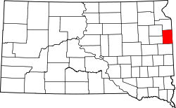
Deuel County[1] ist ein County im Bundesstaat South Dakota der Vereinigten Staaten von Amerika.
Inhaltsverzeichnis
Geographie
Der Bezirk hat eine Fläche von 1.649 Quadratkilometern; davon sind 34 Quadratkilometer (2,07 Prozent) Wasserflächen. Er ist in 16 Townships eingeteilt: Altamont, Antelope Valley, Blom, Brandt, Clear Lake, Glenwood, Goodwin, Grange, Havana, Herrick, Hidewood, Lowe, Norden, Portland, Rome und Scandinavia.
Bevölkerungsentwicklung
Historische Einwohnerzahlen Census Einwohner ± in % 1900 6656 — 1910 7768 20 % 1920 8759 10 % 1930 8732 -0,3 % 1940 8450 -3 % 1950 7689 -9 % 1960 6782 -10 % 1970 5686 -20 % 1980 5289 -7 % 1990 4522 -10 % 2000 4498 -0,5 % 2010 4364 -3 % 1900–1990[2] 2000[3]
Städte und Gemeinden
Städte (cities)
- Clear Lake
- Gary
Gemeinden (towns)
- Altamont
- Astoria
- Brandt
- Goodwin
- Toronto
Einzelnachweise
- ↑ Deuel County im Geographic Names Information System des United States Geological Survey. Abgerufen am 22. Februar 2011
- ↑ Auszug aus Census.gov. Abgerufen am 28. Februar 2011
- ↑ Auszug aus factfinder.census.gov Abgerufen am 28. Februar 2011

Liste der Countys in South Dakota
Aurora | Beadle | Bennett | Bon Homme | Brookings | Brown | Brule | Buffalo | Butte | Campbell | Charles Mix | Clark | Clay | Codington | Corson | Custer | Davison | Day | Deuel | Dewey | Douglas | Edmunds | Fall River | Faulk | Grant | Gregory | Haakon | Hamlin | Hand | Hanson | Harding | Hughes | Hutchinson | Hyde | Jackson | Jerauld | Jones | Kingsbury | Lake | Lawrence | Lincoln | Lyman | Marshall | McCook | McPherson | Meade | Mellette | Miner | Minnehaha | Moody | Pennington | Perkins | Potter | Roberts | Sanborn | Shannon | Spink | Stanley | Sully | Todd | Tripp | Turner | Union | Walworth | Yankton | Ziebach
Wikimedia Foundation.
Schlagen Sie auch in anderen Wörterbüchern nach:
Deuel County, South Dakota — Location in the state of South Dakota … Wikipedia
National Register of Historic Places listings in Deuel County, South Dakota — Location of Deuel County in South Dakota This is a list of the National Register of Historic Places listings in Deuel County, South Dakota. This is intended to be a complete list of the properties and districts on the National Register of… … Wikipedia
Grant County, South Dakota — Location in the state of South Dakota … Wikipedia
Codington County, South Dakota — Location in the state of South Dakota … Wikipedia
Ziebach County (South Dakota) — Verwaltung US Bundesstaat: South Dakota Verwaltungssitz: Dupree Adresse des Verwaltungssitzes: Gründung … Deutsch Wikipedia
Minnehaha County (South Dakota) — Verwaltung US Bundesstaat: South Dakota Verwaltungssitz: Sioux Falls Adresse des Verwaltungssitzes: Gründung … Deutsch Wikipedia
Brookings County, South Dakota — Infobox U.S. County county = Brookings County state = South Dakota founded year = 1871 founded date = July 3 seat wl = Brookings largest city wl = area total sq mi = 805 area total km2 = 2084 area land sq mi = 794 area land km2 = 2058 area water… … Wikipedia
Hamlin County, South Dakota — Infobox U.S. County county = Hamlin County state = South Dakota founded year = founded date = seat wl = Hayti largest city wl = area total sq mi = 538 area total km2 = 1393 area land sq mi =507 area land km2 = 1313 area water sq mi = 31 area… … Wikipedia
Clay County, South Dakota — Location in the state of South Dakota … Wikipedia
Union County, South Dakota — Location in the state of South Dakota … Wikipedia
Deuel County (South Dakota)

18+
© Academic, 2000-2024
- Kontaktieren Sie uns: Unterstützung, Werbung
Wörterbücher Export, schritte mit PHP, Joomla, Drupal, WordPress, MODx.