- Bon Homme County
-
Verwaltung US-Bundesstaat: South Dakota Verwaltungssitz: Tyndall Gründung: Demographie Einwohner: 7260 (2000) Bevölkerungsdichte: 5 Einwohner/km² Geographie Fläche gesamt: 1.506 km² Wasserfläche: 47 km² Karte 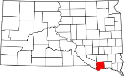
Bon Homme County[1] ist ein County im Bundesstaat South Dakota der Vereinigten Staaten von Amerika. Es liegt im Süden des Bundesstaates an der Grenze zu Nebraska. Im County leben 7260 Einwohner. Der Verwaltungssitz (County Seat) ist Tyndall.
Inhaltsverzeichnis
Geografie
Das County liegt im Südosten von South Dakota, grenzt im Süden an Nebraska und hat eine Fläche von 1.506 Quadratkilometern; davon sind 47 Quadratkilometer (3,09 Prozent) Wasserflächen. Bon Homme County grenzt im Uhrzeigersinn an folgende andere Countys: Hutchinson County, Yankton County, Knox County und Charles Mix County.
Bevölkerungsentwicklung
Historische Einwohnerzahlen Census Einwohner ± in % 1900 10.379 — 1910 11.061 7 % 1920 11.940 8 % 1930 11.737 -2 % 1940 10.241 -10 % 1950 9440 -8 % 1960 9229 -2 % 1970 8577 -7 % 1980 8059 -6 % 1990 7089 -10 % 2000 7260 2 % 2010 7070 -3 % 1900–1990[2] 2000[3]
Städte und Dörfer
- Avon
- Scotland
- Springfield
- Tabor
- Tyndall
Einzelnachweise
- ↑ Bon Homme County im Geographic Names Information System des United States Geological Survey. Abgerufen am 22. Februar 2011
- ↑ Auszug aus Census.gov. Abgerufen am 28. Februar 2011
- ↑ Auszug aus factfinder.census.gov Abgerufen am 28. Februar 2011

Liste der Countys in South Dakota
Aurora | Beadle | Bennett | Bon Homme | Brookings | Brown | Brule | Buffalo | Butte | Campbell | Charles Mix | Clark | Clay | Codington | Corson | Custer | Davison | Day | Deuel | Dewey | Douglas | Edmunds | Fall River | Faulk | Grant | Gregory | Haakon | Hamlin | Hand | Hanson | Harding | Hughes | Hutchinson | Hyde | Jackson | Jerauld | Jones | Kingsbury | Lake | Lawrence | Lincoln | Lyman | Marshall | McCook | McPherson | Meade | Mellette | Miner | Minnehaha | Moody | Pennington | Perkins | Potter | Roberts | Sanborn | Shannon | Spink | Stanley | Sully | Todd | Tripp | Turner | Union | Walworth | Yankton | Ziebach
Wikimedia Foundation.
Schlagen Sie auch in anderen Wörterbüchern nach:
Bon Homme County — Admin ASC 2 Code Orig. name Bon Homme County Country and Admin Code US.SD.009 US … World countries Adminstrative division ASC I-II
Bon Homme County, South Dakota — Infobox U.S. County county = Bon Homme County state = South Dakota founded year = founded date = seat wl = Tyndall largest city wl = area total sq mi = 581 area total km2 = 1506 area land sq mi = 563 area land km2 = 1459 area water sq mi = 18… … Wikipedia
National Register of Historic Places listings in Bon Homme County, South Dakota — Location of Bon Homme County in South Dakota This is a list of the National Register of Historic Places listings in Bon Homme County, South Dakota. This is intended to be a complete list of the properties and districts on the National Register of … Wikipedia
Condado de Bon Homme — Condados de Dakota del Sur Mapa … Wikipedia Español
Comté de Bon Homme — (Bon Homme County) Administration Pays … Wikipédia en Français
List of South Dakota county name etymologies — This is a list of South Dakota county name etymologies: Alphabetical, by first letter A* Aurora County: Aurora is named for Aurora, Greco Roman goddess of the dawn.B* Beadle County: Beadle is named for military officer and local leader William… … Wikipedia
List of U.S. county name etymologies, A-D — This is a list of U.S. county name etymologies, covering the letters A to D. A *Aitkin County, Minnesota: Aitkin is named for William Alexander Aitken, a fur trader in the region. *Alachua County, Florida: Alachua is named for a Native American… … Wikipedia
Charles Mix County, South Dakota — Charles Mix County Courthouse in Lake Andes … Wikipedia
Minnehaha County (South Dakota) — Verwaltung US Bundesstaat: South Dakota Verwaltungssitz: Sioux Falls Adresse des Verwaltungssitzes: Gründung … Deutsch Wikipedia
Ziebach County (South Dakota) — Verwaltung US Bundesstaat: South Dakota Verwaltungssitz: Dupree Adresse des Verwaltungssitzes: Gründung … Deutsch Wikipedia
Bon Homme County

18+
© Academic, 2000-2026
- Kontaktieren Sie uns: Unterstützung, Werbung
Wörterbücher Export, schritte mit PHP, Joomla, Drupal, WordPress, MODx.