- Campbell County (South Dakota)
-
Verwaltung US-Bundesstaat: South Dakota Verwaltungssitz: Mound City Gründung: 1883 Demographie Einwohner: 1782 (2000) Bevölkerungsdichte: 0,9 Einwohner/km² Geographie Fläche gesamt: 1.998 km² Wasserfläche: 92 km² Karte 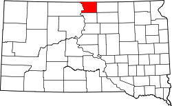
Campbell County[1] ist ein County im Norden des US-Bundesstaates South Dakota, Vereinigte Staaten. Es hat 1782 Einwohner. Der Verwaltungssitz (County Seat) ist Mound City.
Inhaltsverzeichnis
Geographie
Das County hat eine Fläche von 1998 Quadratkilometern; davon sind 92 Quadratkilometer (4,61 Prozent) Wasserflächen.
Bevölkerungsentwicklung
Historische Einwohnerzahlen Census Einwohner ± in % 1900 4527 — 1910 5244 20 % 1920 5305 1 % 1930 5629 6 % 1940 5033 -10 % 1950 4046 -20 % 1960 3531 -10 % 1970 2866 -20 % 1980 2243 -20 % 1990 1965 -10 % 2000 1782 -9 % 2010 1466 -20 % 1900–1990[2] 2000[3]
Städte und Gemeinden
Städte (cities)
- Herreid
Gemeinden (Towns)
- Artas
- Mound City
- Pollock
Einzelnachweise
- ↑ Campbell County im Geographic Names Information System des United States Geological Survey. Abgerufen am 22. Februar 2011
- ↑ Auszug aus Census.gov. Abgerufen am 28. Februar 2011
- ↑ Auszug aus factfinder.census.gov Abgerufen am 28. Februar 2011

Liste der Countys in South Dakota
Aurora | Beadle | Bennett | Bon Homme | Brookings | Brown | Brule | Buffalo | Butte | Campbell | Charles Mix | Clark | Clay | Codington | Corson | Custer | Davison | Day | Deuel | Dewey | Douglas | Edmunds | Fall River | Faulk | Grant | Gregory | Haakon | Hamlin | Hand | Hanson | Harding | Hughes | Hutchinson | Hyde | Jackson | Jerauld | Jones | Kingsbury | Lake | Lawrence | Lincoln | Lyman | Marshall | McCook | McPherson | Meade | Mellette | Miner | Minnehaha | Moody | Pennington | Perkins | Potter | Roberts | Sanborn | Shannon | Spink | Stanley | Sully | Todd | Tripp | Turner | Union | Walworth | Yankton | Ziebach
Wikimedia Foundation.
Schlagen Sie auch in anderen Wörterbüchern nach:
Campbell County, South Dakota — Infobox U.S. County county = Campbell County state = South Dakota founded year = 1883 [ Legislative Manual, South Dakota, 2005, p. 596] founded date = seat wl = Mound City largest city wl = Herreid area total sq mi = 771 area total km2 = 1998… … Wikipedia
National Register of Historic Places listings in Campbell County, South Dakota — Location of Campbell County in South Dakota This is a list of the National Register of Historic Places listings in Campbell County, South Dakota. This is intended to be a complete list of the properties on the National Register of Historic Places … Wikipedia
McPherson County, South Dakota — Location in the state of South Dakota … Wikipedia
Corson County, South Dakota — Corson County Courthouse in McIntosh, South Dakota in 1993. This building was destroyed by fire on April 10, 2006 … Wikipedia
Minnehaha County (South Dakota) — Verwaltung US Bundesstaat: South Dakota Verwaltungssitz: Sioux Falls Adresse des Verwaltungssitzes: Gründung … Deutsch Wikipedia
Ziebach County (South Dakota) — Verwaltung US Bundesstaat: South Dakota Verwaltungssitz: Dupree Adresse des Verwaltungssitzes: Gründung … Deutsch Wikipedia
Walworth County, South Dakota — Infobox U.S. County county = Walworth County state = South Dakota founded year = founded date = seat wl = Selby largest city wl = area total sq mi = 744 area total km2 = 1928 area land sq mi = 708 area land km2 = 1833 area water sq mi = 36 area… … Wikipedia
Clay County, South Dakota — Location in the state of South Dakota … Wikipedia
Union County, South Dakota — Location in the state of South Dakota … Wikipedia
Minnehaha County, South Dakota — Minnehaha County Courthouse in Sioux Falls, South Dakota … Wikipedia
Campbell County (South Dakota)

18+
© Academic, 2000-2026
- Kontaktieren Sie uns: Unterstützung, Werbung
Wörterbücher Export, schritte mit PHP, Joomla, Drupal, WordPress, MODx.