- McPherson County (South Dakota)
-
Verwaltung US-Bundesstaat: South Dakota Verwaltungssitz: Leola Gründung: 1973 Demographie Einwohner: 2083 (2000) Bevölkerungsdichte: 0,7 Einwohner/km² Geographie Fläche gesamt: 2.983 km² Wasserfläche: 39 km² Karte 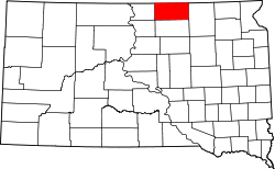
McPherson County[1] ist ein County im Bundesstaat South Dakota der Vereinigten Staaten von Amerika. Er wurde nach James B. McPherson, einem General im Sezessionskrieg, benannt. Der Sitz der Countyverwaltung (County Seat) ist in Leola.
Inhaltsverzeichnis
Geographie
Das County hat eine Fläche von 2.983 Quadratkilometern; davon sind 39 Quadratkilometer (1,29 Prozent) Wasserflächen. Er ist in fünf Townships eingeteilt: Carl, Hoffman, Wachter, Wacker und Weber; sowie zwei unorganisierte Territorien: West McPherson und Central McPherson
Bevölkerungsentwicklung
Historische Einwohnerzahlen Census Einwohner ± in % 1900 6327 — 1910 6791 7 % 1920 7705 10 % 1930 8774 10 % 1940 8353 -5 % 1950 7071 -20 % 1960 5821 -20 % 1970 5022 -10 % 1980 4027 -20 % 1990 3228 -20 % 2000 2904 -10 % 2010 2459 -20 % 1900–1990[2] 2000[3]
Städte und Gemeinden
Städte (cities)
- Eureka
- Leola
Gemeinden (towns)
- Hillsview
- Long Lake
- Wetonka
Einzelnachweise
- ↑ McPherson County im Geographic Names Information System des United States Geological Survey. Abgerufen am 22. Februar 2011
- ↑ Auszug aus Census.gov. Abgerufen am 28. Februar 2011
- ↑ Auszug aus factfinder.census.gov Abgerufen am 28. Februar 2011

Liste der Countys in South Dakota
Aurora | Beadle | Bennett | Bon Homme | Brookings | Brown | Brule | Buffalo | Butte | Campbell | Charles Mix | Clark | Clay | Codington | Corson | Custer | Davison | Day | Deuel | Dewey | Douglas | Edmunds | Fall River | Faulk | Grant | Gregory | Haakon | Hamlin | Hand | Hanson | Harding | Hughes | Hutchinson | Hyde | Jackson | Jerauld | Jones | Kingsbury | Lake | Lawrence | Lincoln | Lyman | Marshall | McCook | McPherson | Meade | Mellette | Miner | Minnehaha | Moody | Pennington | Perkins | Potter | Roberts | Sanborn | Shannon | Spink | Stanley | Sully | Todd | Tripp | Turner | Union | Walworth | Yankton | Ziebach
Wikimedia Foundation.
Schlagen Sie auch in anderen Wörterbüchern nach:
McPherson County, South Dakota — Location in the state of South Dakota … Wikipedia
National Register of Historic Places listings in McPherson County, South Dakota — Location of McPherson County in South Dakota This is a list of the National Register of Historic Places listings in McPherson County, South Dakota. This is intended to be a complete list of the properties on the National Register of Historic… … Wikipedia
Wacker Township, McPherson County, South Dakota — Wacker Township is one of the five townships of McPherson County, South Dakota, United States. It lies in the northeastern part of the county and borders the following other townships within McPherson County: *Hoffman Township south *Weber… … Wikipedia
Wachter Township, McPherson County, South Dakota — Wachter Township is one of the five townships of McPherson County, South Dakota, United States. It lies in the northeastern corner of the county and borders the following other townships within McPherson County: *Carl Township south *Weber… … Wikipedia
Hoffman Township, McPherson County, South Dakota — Hoffman Township is one of the five townships of McPherson County, South Dakota, United States. It lies in the northeastern part of the county and borders the following other townships within McPherson County: *Wacker Township north *Weber… … Wikipedia
Weber Township, McPherson County, South Dakota — Weber Township is one of the five townships of McPherson County, South Dakota, United States. It lies in the northeastern part of the county and borders the following other townships within McPherson County: *Wachter Township east *Carl Township… … Wikipedia
Carl Township, McPherson County, South Dakota — Carl Township is one of the five townships of McPherson County, South Dakota, United States. It lies in the northeastern part of the county and borders the following other townships within McPherson County: *Wachter Township north *Weber Township … Wikipedia
Edmunds County, South Dakota — Location in the state of South Dakota … Wikipedia
Minnehaha County (South Dakota) — Verwaltung US Bundesstaat: South Dakota Verwaltungssitz: Sioux Falls Adresse des Verwaltungssitzes: Gründung … Deutsch Wikipedia
Ziebach County (South Dakota) — Verwaltung US Bundesstaat: South Dakota Verwaltungssitz: Dupree Adresse des Verwaltungssitzes: Gründung … Deutsch Wikipedia
McPherson County (South Dakota)

18+
© Academic, 2000-2026
- Kontaktieren Sie uns: Unterstützung, Werbung
Wörterbücher Export, schritte mit PHP, Joomla, Drupal, WordPress, MODx.