- Brule County
-
Verwaltung US-Bundesstaat: South Dakota Verwaltungssitz: Chamberlain Gründung: Demographie Einwohner: 5364 (2000) Bevölkerungsdichte: 2,5 Einwohner/km² Geographie Fläche gesamt: 2.192 km² Wasserfläche: 71 km² Karte 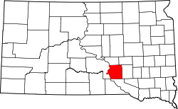
Brule County[1] ist ein Bezirk im Bundesstaat South Dakota der Vereinigten Staaten von Amerika. Die Einwohnerzahl betrug im Jahr 2000 5.364 Personen. Der Sitz der Countyverwaltung (County Seat) in Chamberlain.
Inhaltsverzeichnis
Geografie
Das County hat eine Fläche von 2192 Quadratkilometern; davon sind 71 Quadratkilometer (3,25 Prozent) Wasserflächen.
Bevölkerungsentwicklung
Historische Einwohnerzahlen Census Einwohner ± in % 1900 5401 — 1910 6451 20 % 1920 7141 10 % 1930 7416 4 % 1940 6195 -20 % 1950 6076 -2 % 1960 6319 4 % 1970 5870 -7 % 1980 5245 -10 % 1990 5485 5 % 2000 5364 -2 % 2010 5255 -2 % 1900–1990[2] 2000[3]
Städte und Gemeinden
Städte (Citys)
Gemeinden (Towns)
Einzelnachweise
- ↑ Brule County im Geographic Names Information System des United States Geological Survey. Abgerufen am 22. Februar 2011
- ↑ Auszug aus Census.gov. Abgerufen am 28. Februar 2011
- ↑ Auszug aus factfinder.census.gov Abgerufen am 28. Februar 2011

Liste der Countys in South Dakota
Aurora | Beadle | Bennett | Bon Homme | Brookings | Brown | Brule | Buffalo | Butte | Campbell | Charles Mix | Clark | Clay | Codington | Corson | Custer | Davison | Day | Deuel | Dewey | Douglas | Edmunds | Fall River | Faulk | Grant | Gregory | Haakon | Hamlin | Hand | Hanson | Harding | Hughes | Hutchinson | Hyde | Jackson | Jerauld | Jones | Kingsbury | Lake | Lawrence | Lincoln | Lyman | Marshall | McCook | McPherson | Meade | Mellette | Miner | Minnehaha | Moody | Pennington | Perkins | Potter | Roberts | Sanborn | Shannon | Spink | Stanley | Sully | Todd | Tripp | Turner | Union | Walworth | Yankton | Ziebach
Wikimedia Foundation.
Schlagen Sie auch in anderen Wörterbüchern nach:
Brule County — Admin ASC 2 Code Orig. name Brule County Country and Admin Code US.SD.015 US … World countries Adminstrative division ASC I-II
Brule County, South Dakota — Infobox U.S. County county = Brule County state = South Dakota founded year = founded date = seat wl = Chamberlain largest city wl = area total sq mi = 846 area total km2 = 2192 area land sq mi = 819 area land km2 = 2121 area water sq mi = 28… … Wikipedia
National Register of Historic Places listings in Brule County, South Dakota — Location of Brule County in South Dakota This is a list of the National Register of Historic Places listings in Brule County, South Dakota. This is intended to be a complete list of the properties on the National Register of Historic Places in… … Wikipedia
Brule, Wisconsin — Town Location of Brule, Wisconsin Coordinate … Wikipedia
Brûlé, Alberta — Infobox Settlement official name = Hamlet of Brûlé other name = native name = nickname = settlement type = Hamlet motto = imagesize = image caption = flag size = image seal size = image shield = shield size = city logo = citylogo size = mapsize … Wikipedia
Brule, Nebraska — Infobox Settlement official name = Brule, Nebraska settlement type = Village nickname = motto = imagesize = image caption = image imagesize = image caption = image mapsize = 250px map caption = Location of Brule, Nebraska mapsize1 = map caption1 … Wikipedia
Brule River State Forest — Geobox|Protected area name = Brule River State Forest category = Wisconsin State Forest category iucn = V image caption = country = United States country state = Wisconsin state state type = State region type = County region = Douglas city type … Wikipedia
Condado de Brule — Condados de Dakota del Sur Mapa … Wikipedia Español
List of U.S. county name etymologies, A-D — This is a list of U.S. county name etymologies, covering the letters A to D. A *Aitkin County, Minnesota: Aitkin is named for William Alexander Aitken, a fur trader in the region. *Alachua County, Florida: Alachua is named for a Native American… … Wikipedia
List of South Dakota county name etymologies — This is a list of South Dakota county name etymologies: Alphabetical, by first letter A* Aurora County: Aurora is named for Aurora, Greco Roman goddess of the dawn.B* Beadle County: Beadle is named for military officer and local leader William… … Wikipedia
Brule County

18+
© Academic, 2000-2026
- Kontaktieren Sie uns: Unterstützung, Werbung
Wörterbücher Export, schritte mit PHP, Joomla, Drupal, WordPress, MODx.