- Meade County (South Dakota)
-
Verwaltung US-Bundesstaat: South Dakota Verwaltungssitz: Sturgis Gründung: 1889 Demographie Einwohner: 24.253 (2000) Bevölkerungsdichte: 2,7 Einwohner/km² Geographie Fläche gesamt: 9.020 km² Wasserfläche: 31 km² Karte 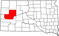
Website: www.meadecounty.org Meade County[1] ist ein County im Bundesstaat South Dakota der Vereinigten Staaten von Amerika. Bei der Volkszählung im Jahr 2000 hatte Meade County 24.253 Einwohner.
Inhaltsverzeichnis
Geschichte
Es wurde im Jahre 1889 gegründet, und nach dem Fort Meade benannt. Das Fort Meade diente im Jahre 1878 als Garnison für die Militärpost. Den Namen hat das Fort Meade nach dem General George Meade erhalten. Der Verwaltungssitz (County Seat) ist Sturgis.
Geographie
Meade County hat eine Fläche von 9020 Quadratkilometern, davon sind 8989 km² Land und 31 km² (0,34 %) Wasserfläche, damit ist der Bezirk der größte in Süddakota und ist etwa halb so groß wie Rheinland-Pfalz, hat aber bei knapp 25.000 Einwohnern nur eine Bevölkerungsdichte von 2,7 Einwohnern pro Quadratkilometer. Es grenzt im Uhrzeigersinn an die Countys: Perkins County, Ziebach County, Pennington County, Lawrence County und Butte County
Bevölkerungsentwicklung
Historische Einwohnerzahlen Census Einwohner ± in % 1900 4907 — 1910 12.640 200 % 1920 9367 -30 % 1930 11.482 20 % 1940 9735 -20 % 1950 11.516 20 % 1960 12.044 5 % 1970 16.618 40 % 1980 20.717 20 % 1990 21.878 6 % 2000 24.253 10 % 2010 25.434 5 % 1900–1990[2] 2000[3]
Altersstruktur
- unter 18 = 28,4 Prozent
- 18–24 = 10,6 Prozent
- 25–44 = 29,6 Prozent
- 45–64 = 21,0 Prozent
- über 65 = 10,4 0%
Städte und Gemeinden
Städte (cities)
- Box Elder
- Faith
- Sturgis
- Summerset
Sonstige
- Blachhawk (census-designated place)
- Ellsworth AFB (Militärflugplatz)
Townships
Das County ist in sechs Townships eingeteilt: Dakota, Eagle, Howard, Lakeside, Smithville und Upper Red Owl; sowie drei Unorganisierte Territorien: Belle Fourche-Cheyenne Valleys, North Meade und Southwest Meade.
Weblinks
Einzelnachweise
- ↑ Meade County im Geographic Names Information System des United States Geological Survey. Abgerufen am 22. Februar 2011
- ↑ Auszug aus Census.gov. Abgerufen am 28. Februar 2011
- ↑ Auszug aus factfinder.census.gov Abgerufen am 28. Februar 2011

Liste der Countys in South Dakota
Aurora | Beadle | Bennett | Bon Homme | Brookings | Brown | Brule | Buffalo | Butte | Campbell | Charles Mix | Clark | Clay | Codington | Corson | Custer | Davison | Day | Deuel | Dewey | Douglas | Edmunds | Fall River | Faulk | Grant | Gregory | Haakon | Hamlin | Hand | Hanson | Harding | Hughes | Hutchinson | Hyde | Jackson | Jerauld | Jones | Kingsbury | Lake | Lawrence | Lincoln | Lyman | Marshall | McCook | McPherson | Meade | Mellette | Miner | Minnehaha | Moody | Pennington | Perkins | Potter | Roberts | Sanborn | Shannon | Spink | Stanley | Sully | Todd | Tripp | Turner | Union | Walworth | Yankton | Ziebach
Wikimedia Foundation.
Schlagen Sie auch in anderen Wörterbüchern nach:
Meade County, South Dakota — Location in the state of South Dakota … Wikipedia
National Register of Historic Places listings in Meade County, South Dakota — Location of Meade County in South Dakota This is a list of the National Register of Historic Places listings in Meade County, South Dakota. This is intended to be a complete list of the properties and districts on the National Register of… … Wikipedia
Minnehaha County (South Dakota) — Verwaltung US Bundesstaat: South Dakota Verwaltungssitz: Sioux Falls Adresse des Verwaltungssitzes: Gründung … Deutsch Wikipedia
Ziebach County (South Dakota) — Verwaltung US Bundesstaat: South Dakota Verwaltungssitz: Dupree Adresse des Verwaltungssitzes: Gründung … Deutsch Wikipedia
Perkins County, South Dakota — Infobox U.S. County county = Perkins County state = South Dakota founded year = founded date = seat wl = Bison largest city wl = area total sq mi = 2891 area total km2 = 7487 area land sq mi = 2872 area land km2 = 7437 area water sq mi = 19 area… … Wikipedia
Pennington County, South Dakota — Infobox U.S. County county = Pennington County state = South Dakota founded year = founded date = seat wl = Rapid City largest city wl = Rapid City area total sq mi = 2784 area total km2 = 7211 area land sq mi =2776 area land km2 = 7190 area… … Wikipedia
Ziebach County, South Dakota — Infobox U.S. County county = Ziebach County state = South Dakota founded year = founded date = seat wl = Dupree largest city wl = Dupree area total sq mi = 1971 area total km2 = 5105 area land sq mi = 1962 area land km2 = 5082 area water sq mi =… … Wikipedia
Lawrence County, South Dakota — Infobox U.S. County county = Lawrence County state = South Dakota founded year = founded date = seat wl = Deadwood largest city wl = area total sq mi = 800 area total km2 = 2073 area land sq mi = 800 area land km2 = 2072 area water sq mi … Wikipedia
Butte County, South Dakota — Infobox U.S. County county = Butte County state = South Dakota founded year = founded date = seat wl = Belle Fourche largest city wl = area total sq mi = 2266 area total km2 = 5870 area land sq mi = 2249 area land km2 = 5824 area water sq mi = 18 … Wikipedia
Minnehaha County, South Dakota — Minnehaha County Courthouse in Sioux Falls, South Dakota … Wikipedia
Meade County (South Dakota)

18+
© Academic, 2000-2026
- Kontaktieren Sie uns: Unterstützung, Werbung
Wörterbücher Export, schritte mit PHP, Joomla, Drupal, WordPress, MODx.