- Todd County (South Dakota)
-
Verwaltung US-Bundesstaat: South Dakota Verwaltungssitz: keinen, Verwaltung ist in Winner Gründung: 1909 Demographie Einwohner: 9050 (2000) Bevölkerungsdichte: 2,5 Einwohner/km² Geographie Fläche gesamt: 3.602 km² Wasserfläche: 7 km² Karte 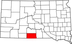
Todd County[1] ist ein Bezirk im Bundesstaat South Dakota der Vereinigten Staaten von Amerika. Das County ist eines von zwei Countys in Süddakota, welche keinen offiziellen Verwaltungssitz (County Seat) haben. Die Verwaltung von Todd County ist in Winner, im benachbarten Tripp County, angesiedelt.
Inhaltsverzeichnis
Geographie
Das County hat eine Fläche von 3602 Quadratkilometern. Davon sind 7 Quadratkilometer (0,20 Prozent) Wasserflächen. Das County ist in zwei unorganisierte Territorien eingeteilt: West Todd und East Todd. Das County liegt innerhalb des Rosebud-Reservats. Der Hauptteil dieses Reservats befindet sich im Todd County, weitere Teile befinden sich in vier weiteren Countys.
Geschichte
Todd County wurde 1909 gegründet, zuvor gab es einen anderen Bezirk des Namens in South Dakota weiter östlich am Missouri River. Der Bezirk wurde nach John Blair Smith Todd, einem Delegierten des Dakota-Territorium im Repräsentantenhaus der Vereinigten Staaten und General im Sezessionskrieg, benannt.
Bevölkerungsentwicklung
Historische Einwohnerzahlen Census Einwohner ± in % 1910 2164 — 1920 2784 30 % 1930 5898 100 % 1940 5714 -3 % 1950 4758 -20 % 1960 4661 -2 % 1970 6606 40 % 1980 7328 10 % 1990 8352 10 % 2000 9050 8 % 2010 9612 6 % 1900–1990[2] 2000[3]
Städte und Gemeinden
Städte (cities)
- Mission
Gemeinden (towns)
- St. Francis
- Antelope
- Parmelee
- Rosebud
- Spring Creek
- Two Strike
- White Horse
Einzelnachweise
- ↑ Todd County im Geographic Names Information System des United States Geological Survey. Abgerufen am 22. Februar 2011
- ↑ Auszug aus Census.gov. Abgerufen am 28. Februar 2011
- ↑ Auszug aus factfinder.census.gov Abgerufen am 28. Februar 2011

Liste der Countys in South Dakota
Aurora | Beadle | Bennett | Bon Homme | Brookings | Brown | Brule | Buffalo | Butte | Campbell | Charles Mix | Clark | Clay | Codington | Corson | Custer | Davison | Day | Deuel | Dewey | Douglas | Edmunds | Fall River | Faulk | Grant | Gregory | Haakon | Hamlin | Hand | Hanson | Harding | Hughes | Hutchinson | Hyde | Jackson | Jerauld | Jones | Kingsbury | Lake | Lawrence | Lincoln | Lyman | Marshall | McCook | McPherson | Meade | Mellette | Miner | Minnehaha | Moody | Pennington | Perkins | Potter | Roberts | Sanborn | Shannon | Spink | Stanley | Sully | Todd | Tripp | Turner | Union | Walworth | Yankton | Ziebach
Wikimedia Foundation.
Schlagen Sie auch in anderen Wörterbüchern nach:
Todd County, South Dakota — Infobox U.S. County county = Todd County state = South Dakota founded year = 1909 [ Legislative Manual, South Dakota, 2005, p. 597] in its present form. (A previous Todd County existed further to the east along the Missouri River.} founded date … Wikipedia
National Register of Historic Places listings in Todd County, South Dakota — Location of Todd County in South Dakota This is a list of the National Register of Historic Places listings in Todd County, South Dakota. This is intended to be a complete list of the properties and districts on the National Register of Historic… … Wikipedia
Mellette County, South Dakota — Location in the state of South Dakota … Wikipedia
Minnehaha County (South Dakota) — Verwaltung US Bundesstaat: South Dakota Verwaltungssitz: Sioux Falls Adresse des Verwaltungssitzes: Gründung … Deutsch Wikipedia
Ziebach County (South Dakota) — Verwaltung US Bundesstaat: South Dakota Verwaltungssitz: Dupree Adresse des Verwaltungssitzes: Gründung … Deutsch Wikipedia
Tripp County, South Dakota — Infobox U.S. County county = Tripp County state = South Dakota founded year = 1909 founded date = seat wl = Winner largest city wl = area total sq mi = 1617 area total km2 = 4189 area land sq mi = 1614 area land km2 = 1479 area water sq mi = 4… … Wikipedia
Bennett County, South Dakota — Infobox U.S. County county = Bennett County state = South Dakota founded year = 1909 founded date = seat wl = Martin largest city wl = area total sq mi = 1191 area total km2 = 3084 area land sq mi = 1185 area land km2 = 3070 area water sq mi = 5… … Wikipedia
Shannon County, South Dakota — Infobox U.S. County county = Shannon County state = South Dakota founded year = founded date = seat wl = largest city wl = Pine Ridge area total sq mi = 2097 area total km2 = 5430 area land sq mi = 2094 area land km2 = 5423 area water sq mi = 3… … Wikipedia
Clay County, South Dakota — Location in the state of South Dakota … Wikipedia
Union County, South Dakota — Location in the state of South Dakota … Wikipedia
Todd County (South Dakota)

18+
© Academic, 2000-2024
- Kontaktieren Sie uns: Unterstützung, Werbung
Wörterbücher Export, schritte mit PHP, Joomla, Drupal, WordPress, MODx.