- Liste der tektonischen Platten
-
Die Liste der tektonischen Platten umfasst nachgewiesene und vermutete tektonische Platten der Erde. Platten, die nicht mehr existieren, sind nicht aufgeführt.
Name Fläche in
Steradiant[1]Lage Afrikanische Platte
(Nubische Platte)[2]1,44065 Afrikanischer Kontinent westlich des ostafrikanischen Grabens Ägäische Platte[3] 0,00793 Peloponnes, Ägäische Inseln, Westküste Anatoliens Altiplano-Platte[4] 0,02050 Südperu, Bolivien, Nordchile Amurplatte[5] 0,13066 Südostrussland östlich des Baikalsees, Mandschurei, Korea, westliche Hauptinseln Japans Anatolische Platte[3] 0,01418 asiatischer Teil der Türkei außer Nord- und Westküste, nördlicher Teil Zyperns Antarktische Platte[2] 1,43268 gesamter Kontinent Antarktika, Südpazifik, größter Teil des Südpolarmeers Arabische Platte[2] 0,12082 Orient südlich von Taurus und Zagros, Arabische Halbinsel Australische Platte[2] 1,13294 Australien, Teile Neuseelands, Südhälfte Neuguineas, südlicher Indischer Ozean bis westlich von Sumatra Balmoral-Riff-Platte[1] 0,00481 nördlicher Teil Fidschis Bandaseeplatte[6] 0,01715 Südhälfte Sulawesis, Bandasee, Ambon (Indonesien) Bird's-Head-Platte[1] 0,01295 Vogelkop, Halmahera (Indonesien) Burmaplatte[7] 0,01270 Andamanen und Nikobaren, Nordspitze Sumatras Cocosplatte[2] 0,07223 Pazifik vor der Küste Mittelamerikas Conway-Riff-Platte[1] 0,00356 südlicher Teil Fidschis Eurasische Platte[2] 1,19630 fast ganz Eurasien, außer Anatolien, Orient, Arabische Halbinsel, Indien, Südostasien und Ostsibirien Futunaplatte[1] 0,00079 Pazifik um Wallis und Futuna Galapagosplatte[8] 0,00036 Pazifik, nahe der Galápagos-Inseln Indische Platte[2] 0,30637 Indien, Sri Lanka, nördlicher Indischer Ozean Juan-de-Fuca-Platte[9] 0,00632 Pazifik vor der Küste Oregons, Washingtons und British Columbias Juan-Fernandez-Platte[10] 0,00241 Pazifik südlich der Osterinsel Karibische Platte[11] 0,07304 Honduras, El Salvador, Nicaragua, Antillen außer Kuba Karolinenplatte[12] 0,03765 Palau, westliche Karolinen (Mikronesien) Kermadecplatte[1] 0,01245 Osthälfte der Nordinsel Neuseelands, Kermadecinseln Manusplatte[13] 0,00020 Pazifik südlich von Lavongai (Papua-Neuguinea) Maokeplatte[1] 0,00284 nordwestlicher Teil Neuguineas ohne die Vogelkop-Halbinsel Marianenplatte[1] 0,01037 Marianen (Westpazifik) Molukkenseeplatte[6] 0,01030 Nordhälfte Sulawesis, Buru, Molukkensee (Indonesien) Nazcaplatte[2] 0,39669 Pazifik zwischen Osterinsel und Südamerika Neue-Hebriden-Platte[1] 0,01585 Neue Hebriden (Südwestpazifik) Niuafo'ou-Platte[14] 0,00306 Pazifik nordwestlich von Tonga Nordamerikanische Platte[2] 1,36559 Nordamerika einschließlich Mexiko und Guatemala, Nordostsibirien, Kuba, westlicher Teil Islands Nordandenplatte[15] 0,02394 Kolumbien, Ecuador Nordbismarckplatte[16] 0,00956 Bismarck-Archipel außer Neubritannien Ochotskplatte[17] 0,07482 Kamtschatka, Sachalin, Kurilen, nördliche Hauptinseln Japans Okinawaplatte[1] 0,00802 Ryukyu-Inseln, Nordspitze Taiwans Osterinselplatte[18] 0,00411 Pazifik westlich der Osterinsel Panamaplatte[19] 0,00674 Panama, Costa Rica Pazifische Platte[1] 2,57685 Pazifik westlich der Osterinsel Philippinenseeplatte[12] 0,13409 Philippinensee, Nordhälfte Luzons Riveraplatte[20] 0,00249 Pazifik vor der Küste Jaliscos (Mexiko) Salomonenseeplatte[1] 0,00317 Salomonensee (Westpazifik) Sandwichplatte[21] 0,00454 Südpolarmeer westlich der Süd-Sandwich-Inseln Scotia-Platte[21] 0,04190 Südpolarmeer von der Drakestraße bis westlich der Süd-Sandwich-Inseln Shetlandplatte[1]
(hypothetisch)0,00178 Süd-Shetland-Inseln (Südpolarmeer) Somaliaplatte[22] 0,47192 Afrika östlich des ostafrikanischen Grabens, Madagaskar, westlicher Indischer Ozean Südamerikanische Platte[2] 1,03045 Südamerika außer Kolumbien, Ecuador, Südperu, Bolivien, Nordchile Südbismarckplatte[23] 0,00762 Neubritannien und Küstenstreifen Neuguineas westlich davon Sundaplatte[6] 0,21967 Sumatra, Borneo, Java, Bali, Sumbawa, Südostasien Timorplatte[1] 0,00870 Flores, Sumba, Timor (Indonesien, Osttimor) Tongaplatte[14] 0,00625 Tonga Woodlarkplatte[16] 0,01116 zentraler Teil Neuguineas Yangtseplatte[5] 0,05425 Südostchina 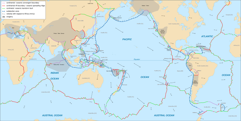 Karte der tektonischen Platten nach Bird 2003[1]. Die Pfeile geben die Bewegungsrichtung der Platte und ihre Geschwindigkeit in Millimeter pro Jahr an.
Weitere Platten
- Oft wird die Südspitze der Juan-de-Fuca-Platte als eigene Platte abgetrennt. Diese trägt dann den Namen Gordaplatte. Die Nordspitze der Juan-de-Fuca-Platte wird teilweise als Explorer-Platte abgetrennt.[24][25]
- Ein Teil der Eurasischen Platte wird als Apulische Platte, ein Teil dieser wiederum als Adriatische Platte bezeichnet.[26] Die Adriatische Platte umfasst den nordöstlichen Teil Italiens sowie der Adria und Teile der Alpen und des Dinarischen Gebirges. Die Apulische Platte umfasst darüber hinaus Süditalien und die südliche Adria, sowie Teile Siziliens.
Quellen und weiterführende Informationen
- ↑ a b c d e f g h i j k l m n o P. Bird (2003): An updated digital model of plate boundaries. in: Geochemistry Geophysics Geosystems 4, Nr. 3, 2001GC000252. PDF (13 MB!)
- ↑ a b c d e f g h i j C. DeMets, R. G. Gordon, D. F. Argus und S. Stein (1994) Effect of recent revisions to the geomagnetic reversal time scale on estimate of current plate motions. in: Geophysical Research Letters 21, Seiten 2191–4.
- ↑ a b S. McClusky, S. et al. (2000) Global Positioning System constraints on plate kinematics and dynamics in the eastern Mediterranean and Caucasus. in: Journal of Geophysical Research 105, Seiten 5695–719.
- ↑ S. Lamb (2000) Active deformation in the Bolivian Andes, South America. in: Journal of Geophysical Research 105, Seiten 25.627–53.
- ↑ a b K. Heki, S. Miyazaki, H. Takahashi, M. Kasahara, F. Kimata, S. Miura, N. F. Vasilenko, A. Ivaschenko und K.-D. An (1999) The Amurian plate motion and current plate kinematics in eastern Asia. in: Journal of Geophysical Research 104, Seiten 29.147–55.
- ↑ a b c C. Rangin, X. Le Pichon, S. Mazzotti, M. Pubellier, N. Chamot-Rooke, M. Aurelio, A. Walpersdorf und R. Quebral (1999) Plate convergence measured by GPS across the Sundaland/Philippine Sea plate deformed boundary: The Philippines and eastern Indonesia. in: Geophysical Journal International 139, Seiten 296–316.
- ↑ M. T. Halbouty et al. (Hrsg.) (1986) Circum-Pacific Map Project: Plate-Tectonic Map of the Circum-Pacific Region. 5 sheets at 1:10,000,000 and 1 sheet at 1:20,000,000. American Association of Petroleum Geologists, Tulsa.
- ↑ P. Lonsdale (1988) Structural pattern of the Galapagos microplate and evolution of the Galapagos triple junctions. in: Journal of Geophysical Research 93, Seiten 13.551–74.
- ↑ D. S. Wilson (1988) Tectonic history of the Juan de Fuca Ridge over the last 40 million years. in: Journal of Geophysical Research 93, Seiten 11.863–76.
- ↑ S. Anderson-Fontana, J. F. Engeln, P. Lundgren, R. L. Larson und S. Stein (1986) Tectonics and evolution of the Juan Fernandez microplate at the Pacific-Nazca-Antarctic plate junction. in: Journal of Geophysical Research 91, Seiten 2005–18.
- ↑ J. C. Weber, T. H. Dixon, C. DeMets, W. B. Ambeh, P. Jansma, G. Mattioli, J. Saleh, G. Sella, R. Bilham und O. Perez (2001) GPS estimate of relative motion between the Caribbean and South American plates, and geologic implications for Trinidad and Venezuela. in Geology 29, Seiten 75–8.
- ↑ a b T. Seno, S. Stein und A. E. Gripp (1993) A model for the motion of the Philippine Sea plate consistent with NUVEL-1 and geological data. in: Journal of Geophysical Research 98, Seiten 17.941–8.
- ↑ F. Martinez und B. Taylor (1996) Fast backarc spreading, rifting, and microplate rotation, between transform faults in the Manus Basin, Bismarck Sea. in: Marine Geophysical Researches 18, 203–24.
- ↑ a b K. E. Zellmer und B. Taylor (2001) A three-plate kinematic model for Lau Basin opening. in: Geochemistry Geophysics Geosystems 2, 2000GC000106.
- ↑ R. Trenkamp, J. N. Kellogg und J. T. Freymueller (1996) Transect of Nazca-South America plate boundary in Ecuador and Columbia: 8 years of CASA GPS results (abstract). in: Eos Trans. AGU, 77 (46), Fall Meeting Supplement, F142.
- ↑ a b P. Tregoning et al. (1998) Estimation of current plate motions in Papua New Guinea from Global Positioning System observations. in: Journal of Geophysical Research 103, Seiten 12.181–203.
- ↑ D. B. Cook, K. Fujita und C. A. McMullen (1986) Present-day plate interactions in northeast Asia; North America, Eurasian, and Okhotsk plates. in: Journal of Geodynamics 6, Seiten 33–51.
- ↑ J. F. Engeln und S. Stein (1984) Tectonics of the Easter plate. in: Earth and Planetary Science Letters 68, Seiten 259–70.
- ↑ J. N. Kellogg, V. Vega, T. C. Stallings und C. L. V. Aiken (1995) Tectonic development of Panama, Costa Rica, and the Columbian Andes: Constraints from Global Positioning System geodetic studies and gravity. in: P. Mann (Hrsg.) Geologic and Tectonic Development of the Caribbean Plate Boundary in Southern Central America. Geological Society of America Special Paper 295, Seiten 75–86.
- ↑ C. DeMets und S. Traylen (2000) Motion of the Rivera plate since 10 Ma relative to the Pacific and North American plates and the mantle. in: Tectonophyics 318, Seiten 119–59.
- ↑ a b A. M. Pelayo und D. A. Wiens (1989) Seismotectonics and relative plate motions in the Scotia Sea region. in: Journal of Geophysical Research 94, Seiten 7293–320.
- ↑ D. Chu und R. G. Gordon (1999) Evidence for motion between Nubia and Somalia along the Southwest Indian ridge. in: Nature 398, Seiten 64–7.
- ↑ P. Tregoning, R. J. Jackson, H. McQueen, K. Lambeck, C. Stevens, R. P. Little, R. Curley und R. Rosa (1999) Motion of the South Bismarck plate, Papua New Guinea. in: Geophysical Research Letters 26, Seiten 3517–20.
- ↑ Informationen des Geologischen Dienstes der USA
- ↑ Informationen der University of Washington
- ↑ Informationen der Universität Lausanne
Kategorien:- Plattentektonik
- Liste (Geologie)

Wikimedia Foundation.