- Mandera District
-
Mandera District Basisdaten Einwohner
- Bevölkerungsdichte313.000 Einw. [1]
12 Einw./km²Fläche 26.474 km² Koordinaten 3° 25′ N, 40° 40′ O3.416666666666740.666666666667Koordinaten: 3° 25′ N, 40° 40′ O 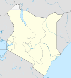

Mandera District Politik Provinz North-Eastern  Lage des Mandera Districts in Kenia
Mandera District ist ein Distrikt in der kenianischen Provinz North-Eastern. Der Distrikt grenzt an Somalia und Äthiopien. Die Hauptstadt ist Mandera. Im Mandera District herrscht arides Klima.
Die Menschen im Mandera District leben hauptsächlich von nomadischer Viehhaltung, nur 5 % der Distriktsfläche gelten als landwirtschaftlich nutzbar. Angebaut werden vor allem Mais, Hirse, Kuhbohnen, Erdnüsse, Bananen und Mangos.
2005 lebten 65 % der Einwohner unterhalb der Armutsgrenze, ungefähr 52 % der Männer und 82 % der Frauen sind Analphabeten. 1999 waren 15,7 % der Einwohner arbeitslos. Die Kindersterblichkeit im Distrikt ist hoch, 12,8 % der Kinder starben im Jahr 2002 vor ihrem 5. Geburtstag.[2]
Infrastruktur
Im Mandera District gibt es 47 medizinische Versorgungseinrichtungen, drei Postämter, 27 Telefonzellen und zwei Finanzdienstleister. Die Straßen sind nicht geteert. Nur 11 % der Bevölkerung hat Zugang zu gutem Trinkwasser, der durchschnittliche Weg zur nächsten Wasserquelle beträgt 20 km. Nur eines der großen Handelszentren verfügt über elektrischen Strom, der Energiebedarf der Menschen wird über Holzfeuerung gedeckt.[2] Im District gab es 2002 60 Primary Schools und sechs Secondary Schools, davon eine für Mädchen.[3]
Gliederung
Der Mandera District teilt sich in 18 Divisionen und drei Wahlbezirke, Mandera East, Mandera Central und Mandera West, auf.
Divisionen Division Fläche in km²[3] Central 102 Khalalio 510 Elwak 632 Wargadud 1.066 Shimbir Fatuma 1.878 Kotulo 2.483 Fino 1.883 Lafey 863 Hareri 1.213 Libehiya 670 Warankara 957 Rhamu 145 Rhamudimtu 935 Ashabito 4.509 Banissa 1.416 Malkamari 1.868 Takaba 3.165 Dandu 2.182 Einzelnachweise
- ↑ kenyafoodsecurity.org (pdf), abgerufen am 6. März 2010.
- ↑ a b kenyafoodsecurity.org (pdf), abgerufen am 6. März 2010.
- ↑ a b Mandera District Plan 2005-2010, abgerufen am 6. März 2010.
 Distrikte in Kenia
Central Province: Kiambu | Kirinyaga | Maragua | Murang’a | Nyandarua | Nyeri | Thika
Coast Province: Kilifi | Kwale | Lamu | Malindi | Mombasa | Taita-Taveta | Tana River
Eastern Province: Embu | Isiolo | Kitui | Machakos | Makueni | Marsabit | Mbeere | Meru Central | Meru North | Meru South | Moyale | Mwingi | Tharaka
North-Eastern Province: Garissa | Ijara | Wajir | Mandera
Nyanza Province: Bondo | Gucha | Homa Bay | Kisii Central | Kisumu | Kuria | Migori | Nyamira | Nyando | Rachuonyo | Siaya | Suba
Rift Valley Province: Baringo | Bomet | Buret | Kajiado | Keiyo | Kericho | Koibatek | Laikipia | Marakwet | Nakuru | Nandi | Narok | Samburu | Trans Mara | Trans-Nzoia | Turkana | Uasin Gishu | West Pokot
Western Province: Bungoma | Busia | Butere/Mumias | Kakamega | Lugari | Mount Elgon | Teso | Vihiga
Nairobi: Nairobi
Wikimedia Foundation.
Schlagen Sie auch in anderen Wörterbüchern nach:
Mandera District — is an administrative district in the North Eastern Province of Kenya. Its capital town is Mandera. The district has a population of 250,372 (1999 census) and an area of 26,744 km² [1]. Local authorities (councils) Authority Type Population* Urban … Wikipedia
Mandera — Mandera … Wikipedia
Mandera Airport — IATA: NDE – ICAO: HKMA … Wikipedia
Mandera East Constituency — is an electoral constituency in Kenya. It is one of three constituencies in Mandera District. The constituency was established for the 1966 elections. Contents 1 Members of Parliament 2 Wards 3 References … Wikipedia
Mandera — Basisdaten Einwohner 30.433 Einw. Koordinaten … Deutsch Wikipedia
Mandera Central Constituency — is an electoral constituency in Kenya. It is one of three constituencies in Mandera District. The constituency has 12 wards, all electing councillors to the Mandera county Council. The constituency was established for the 1988 elections. Contents … Wikipedia
Mandera West Constituency — is an electoral constituency in Kenya. It is one of three constituencies in Mandera District. The constituency has eight wards, all electing councillors to the Mandera County Council. The constituency was established for the 1966 elections.… … Wikipedia
Mandera triangle — The Mandera triangle is a geographical region in Eastern Africa where the countries of Kenya, Ethiopia, and Somalia meet.[1] The tri border region is centered on the city of Mandera in Kenya s North Eastern Province and corresponds with the Juba… … Wikipedia
Mombasa District — District … Wikipedia
Mbeere District — Cumulative rainfall at Masinga dam, Kenya. Mbeere District is an administrative district in the Eastern Province of Kenya. Its capital town is Siakago. The district has a population of 170,950 and an area of 2,093 km².[1] … Wikipedia
Mandera District


18+
© Academic, 2000-2026
- Kontaktieren Sie uns: Unterstützung, Werbung
Wörterbücher Export, schritte mit PHP, Joomla, Drupal, WordPress, MODx.