- Kakamega District
-
Kakamega District Basisdaten Einwohner
- Bevölkerungsdichte603.422 Einw. [1]
433 Einw./km²Fläche 1395 km² Koordinaten 0° 17′ N, 34° 45′ O0.2833333333333334.75Koordinaten: 0° 17′ N, 34° 45′ O 

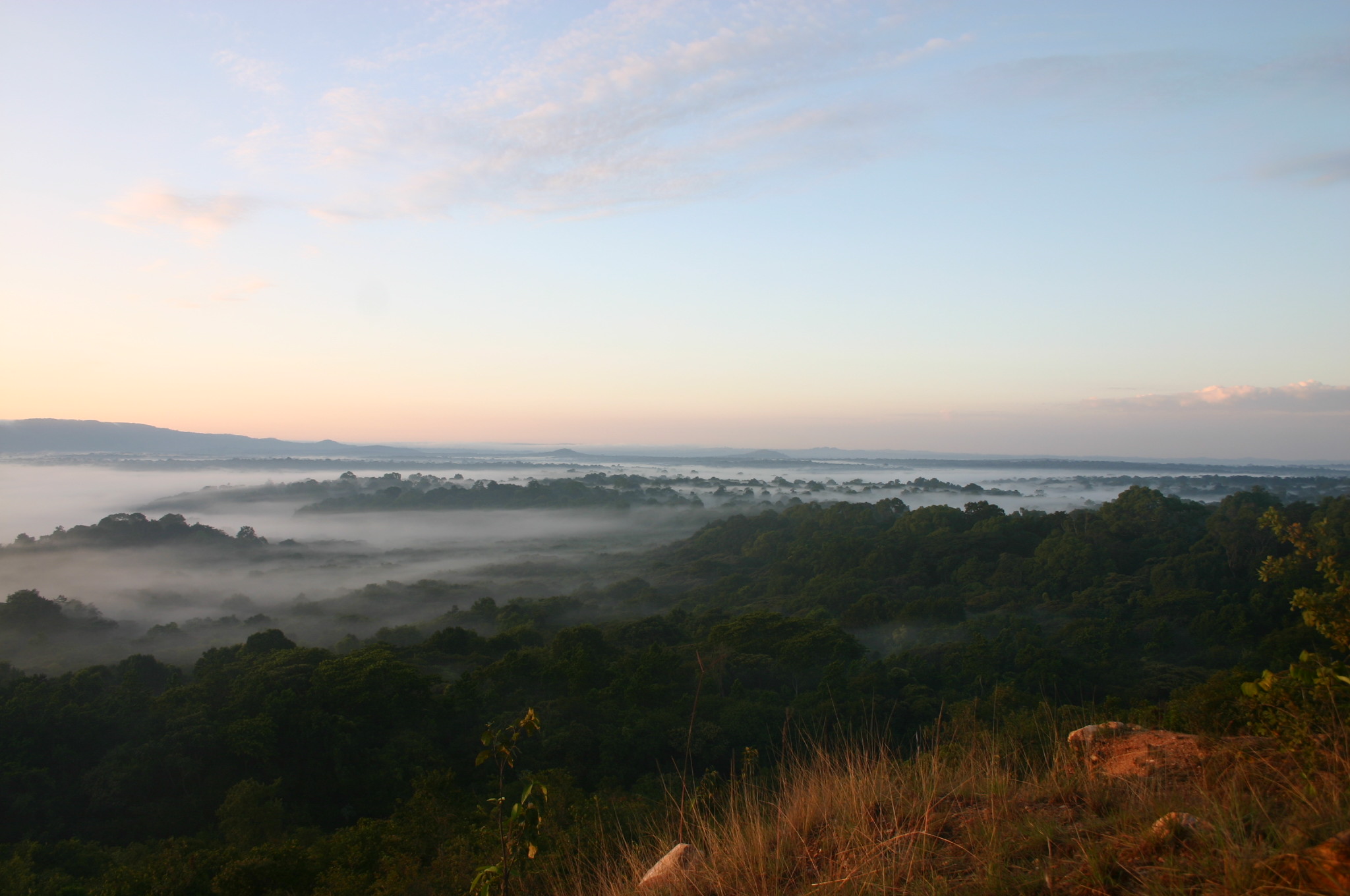
Kakamega District Politik Provinz Western  Blick über das Naturschutzgebiet Kakamega Forest National Reserve.
Kakamega District ist ein Distrikt in der kenianischen Provinz Western. Die Hauptstadt des Distriktes ist Kakamega. Im Distrikt liegt das Naturschutzgebiet Kakamega Forest National Reserve, der letzte Regenwald Kenias.
Inhaltsverzeichnis
Gliederung
Kakamega District teilt sich in sieben Divisionen auf.
Divisionen[2] Division Einwohner Fläche in km² Kakamega Muncipality 74.115 49,9 Lurambi 85.863 194,1 Navakholo 65.337 173,4 Kabras 149.510 424,2 Ileho 32.545 77,7 Shinyalu 103.948 332,6 Ikolomani 92.104 142,9 Gesamt 603.422 1394,8 Wirtschaft
Neben der Viehzucht leben die Menschen im Kakamega District hauptsächlich von der Landwirtschaft. Angebaut werden vor allem Zuckerrohr, Tee, Sonnenblumen und Sojabohnen für den Verkauf, Mais, Süßkartoffeln, Bohnen und Kochbananen für den Eigenbedarf. Ferner werden Avocado, Papaya, Bananen und Ananas angebaut. Die Viehhaltung besteht hauptsächlich aus Rinder- und Geflügelzucht.[3] Im Jahr 2002 lebten knapp 57,5 % der Einwohner unterhalb der Armutsgrenze.[4]
Bildung und Gesundheitswesen
Im Distrikt gibt es verschiedene Primary und Secondary Schools. Die Schulabbrecherrate lag 1999 mit 26 % in der Primary und 5,3 % in der Secondary School recht hoch. Als Gründe für den Abbruch der Primary School werden die von vielen Eltern nicht bezahlbaren Schulgebühren genannt, ebenso wie der Umstand, dass viele Kinder zu Waisen werden und die Schule abbrechen, um sich um jüngere Geschwister zu kümmern. In der Secondary School sind die Gründe für die vorzeitige Beendigung der Ausbildung mehrheitlich frühe Schwangerschaften und/oder frühe Heirat.[5]
Der Distrikt verfügt über 55 Einrichtungen des Gesundheitswesens. Die Kindersterblichkeit ist mit 6,3 % recht hoch, 12,25 % der Kinder sterben vor dem 5. Geburtstag. Außerdem leidet der Kakamega District an einer der höchsten HIV/Aids-Raten in Kenia. Die Prävalenz beträgt 23,8 %.[6]
Einzelnachweise
- ↑ statoids.com, abgerufen am 22. März 2010
- ↑ Kakamega District Plan 2005-2010 (pdf), S. 10, abgerufen am 24. März 2010.
- ↑ Kakamega District Report 2008 auf kenyafoodsecurity.org, abgerufen am 24. März 2010.
- ↑ Kakamega District Plan 2005-2010 (pdf), S. 14, abgerufen am 24. März 2010.
- ↑ Kakamega District Plan 2005-2010 (pdf), S. 13, abgerufen am 24. März 2010.
- ↑ Kakamega District Plan 2005-2010 (pdf), S. 15-16, abgerufen am 24. März 2010.
 Distrikte in Kenia
Central Province: Kiambu | Kirinyaga | Maragua | Murang’a | Nyandarua | Nyeri | Thika
Coast Province: Kilifi | Kwale | Lamu | Malindi | Mombasa | Taita-Taveta | Tana River
Eastern Province: Embu | Isiolo | Kitui | Machakos | Makueni | Marsabit | Mbeere | Meru Central | Meru North | Meru South | Moyale | Mwingi | Tharaka
North-Eastern Province: Garissa | Ijara | Wajir | Mandera
Nyanza Province: Bondo | Gucha | Homa Bay | Kisii Central | Kisumu | Kuria | Migori | Nyamira | Nyando | Rachuonyo | Siaya | Suba
Rift Valley Province: Baringo | Bomet | Buret | Kajiado | Keiyo | Kericho | Koibatek | Laikipia | Marakwet | Nakuru | Nandi | Narok | Samburu | Trans Mara | Trans-Nzoia | Turkana | Uasin Gishu | West Pokot
Western Province: Bungoma | Busia | Butere/Mumias | Kakamega | Lugari | Mount Elgon | Teso | Vihiga
Nairobi: Nairobi
Wikimedia Foundation.
Schlagen Sie auch in anderen Wörterbüchern nach:
Kakamega District — is a district in the Western Province of Kenya. Its capital town is Kakamega. It has a population of 603,422 and an area of 1,395 km² [http://www.statoids.com/yke.html] .The district has four constituencies: *Malava Constituency *Lurambi… … Wikipedia
Kakamega — is also the genus of the Grey chested Illadopsis ( Kakamega poliothorax ), a bird Kakamega is a town in western Kenya lying about 30 km north of the Equator. It is the provincial headquarters of Western Province. It is also headquarters to the… … Wikipedia
Kakamega (comté du Kenya) — Pour les articles homonymes, voir Kakamega (homonymie). 0° 17′ 00″ N 34° 45′ 00″ E … Wikipédia en Français
Kakamega — Pour les articles homonymes, voir Kakamega (homonymie). Kakamega Administration Pays … Wikipédia en Français
Kakamega — ▪ Kenya town, southwestern Kenya, located at an elevation of about 5,100 feet (1,550 metres). The British developed Kakamega for defensive purposes in 1903, and by 1920 it had become the district headquarters. The discovery of gold in 1931… … Universalium
Lugari District — Basisdaten Einwohner Bevölkerungsdichte 215.920 Einw. [1] 322 Einw./km² Fläche 670 km² Koordinaten … Deutsch Wikipedia
Vihiga District — Basisdaten Einwohner Bevölkerungsdichte 498.883 Einw. [1] 886 Einw./km² Fläche 563 km² Koordinaten … Deutsch Wikipedia
Busia District, Kenya — Busia is a district in the Western Province of Kenya. It borders Kakamega District to the east, Bungoma District to the north, Busia District, Uganda to the west, and Lake Victoria to the south.The main economic activity is trade with… … Wikipedia
Vihiga District — is an administrative district in the Western Province of Kenya. Its capital town is Mbale, which is located in Vihiga Division. The district has a population of 498,883 (1999 census) and an area of 563 km² [http://www.statoids.com/yke.html] .… … Wikipedia
Mombasa District — District … Wikipedia
Kakamega District

18+
© Academic, 2000-2026
- Kontaktieren Sie uns: Unterstützung, Werbung
Wörterbücher Export, schritte mit PHP, Joomla, Drupal, WordPress, MODx.