- A659
-
Basisdaten Gesamtlänge: 6 km Bundesländer: Baden-Württemberg
HessenAnschlussstellen und Bauwerke 
Richtung Fürth (Odenwald) 
(1) Kreuz Weinheim 


Tankstelle Viernheim 

(2) Viernheim-Ost L 3111 (3) Viernheim L 631 Tankstelle Viernheim 
(4) Viernheimer Kreuz 

Richtung Mannheim Die Bundesautobahn 659 (Abkürzung: BAB 659) – Kurzform: Autobahn 659 (Abkürzung: A 659) – führt vom Viernheimer Kreuz zum Autobahnkreuz Weinheim. Sie entstand in den 1960er Jahren als Zubringer zur 1968 eröffneten „Bergstraßenautobahn“ (A 5) und ersetzt auf diesem Stück die ursprüngliche Viernheimer Umgehungsstraße (B 38). Vom Viernheimer Kreuz verlängert die gut ausgebaute B 38 die A 659 hinein in die Stadtmitte Mannheims, vom Kreuz Weinheim führt die B 38 hinein in den Odenwald.
Geplant war eine Verlängerung bis Mannheim-Feudenheim mit Anschluss an den Rhein-Neckar-Schnellweg.
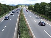 Blick nach Osten auf die Abfahrt Viernheim-Ost
Weblinks

Gebaute Strecken:
Hauptstrecken: A 1 | A 2 | A 3 | A 4 | A 5 | A 6 | A 7 | A 8 | A 9Über- und regional: A 10 | A 11 | A 12 | A 13 | A 14 | A 15 | A 17 | A 19 | A 20 | A 21 | A 23 | A 24 | A 25 | A 26 | A 27 | A 28 | A 29 | A 30 | A 31 | A 33 | A 37 | A 38 | A 39 | A 40 | A 42 | A 43 | A 44 | A 45 | A 46 | A 48 | A 49 | A 52 | A 57 | A 59 | A 60 | A 61 | A 62 | A 63 | A 64 | A 65 | A 66 | A 67 | A 70 | A 71 | A 72 | A 73 | A 81 | A 92 | A 93 | A 94 | A 95 | A 96 | A 98 | A 99
Regional und lokal: A 100 | A 103 | A 111 | A 113 | A 114 | A 115 | A 117 | A 143 | A 210 | A 215 | A 226 | A 250 | A 252 | A 253 | A 255 | A 261 | A 270 | A 280 | A 281 | A 293 | A 352 | A 391 | A 392 | A 395 | A 445 | A 480 | A 485 | A 516 | A 524 | A 535 | A 540 | A 542 | A 544 | A 553 | A 555 | A 559 | A 560 | A 562 | A 565 | A 571 | A 573 | A 602 | A 620 | A 623 | A 643 | A 648 | A 650 | A 656 | A 659 | A 661 | A 671 | A 672 | A 831 | A 861 | A 864 | A 952 | A 980 | A 995
Geplante oder ehemalige Strecken:
A 16 | A 17* | A 18 | A 22 | A 32 | A 34 | A 35 | A 36 | A 40* | A 41 | A 47 | A 50 | A 51 | A 53 | A 54 | A 55 | A 56 | A 69 | A 74 | A 75 | A 77 | A 80 | A 82 | A 83 | A 84 | A 85 | A 86 | A 87 | A 88 | A 89 | A 90 | A 91A 102 | A 104 | A 105 | A 106 | A 107 | A 140 | A 201 | A 205 | A 227 | A 241 | A 263 | A 282 | A 290 | A 314 | A 339 | A 369 | A 376 | A 388 | A 430 | A 432 | A 441 | A 441* | A 443 | A 451 | A 480* | A 533 | A 545 | A 552 | A 558 | A 580 | A 610 | A 621 | A 647 | A 652 | A 653 | A 654 | A 655 | A 680 | A 683 | A 687 | A 713 | A 720 | A 722 | A 731 | A 751 | A 752 | A 753 | A 828 | A 833 | A 834 | A 840 | A 860 | A 862 | A 863 | A 863* | A 881 | A 895 | A 921 | A 922 | A 942 | A 944 | A 985 | A 990 | A 991 | A 992 | A 993 | A 994 | A 996 | A 997 | A 998 | A 999 | * frühere Planung: Nummer wurde später anders vergeben


Wikimedia Foundation.